SPECIAL ANNOUNCEMENT |
 |
We will be issuing intermittent avalanche advisories as conditions warrant. I'll begin to issue regular advisories later in November when the winter season gets rolling....
Hope to see you at the 6th annual "Pray for Snow" FUAC fundraiser dinner on Wednesday, December 2nd at 6:30. This year you'll find the fun and prizes at the Italian Place on Federal Ave. |
|
|
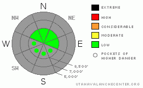
BOTTOM LINE
Danger by aspect and elevation on slopes approaching 35° or steeper.
(click HERE for tomorrow's danger rating)
|
Danger Rose Tutorial
|
There is a LOW danger at upper elevations in the backcountry. You might trigger small wind slab avalanches on very steep slopes with preexisting snow along the highest exposed ridges. |
|
|
CURRENT CONDITIONS |

|
About 11 inches fell at upper elevations in the Bear River Range late last week and over the weekend.
In most areas the fresh snow sits on bare, rocky ground, but there are smooth slopes facing the northern 3/8ths of the compass rose where a solid layer of preexisting old snow acts as a reasonable base. You can find some areas for turning if you're willing to walk a little, but the fresh snow is still too shallow, and there are way too many rocks to ride your sled anywhere but the highest elevation roadways yet.
Click HERE for Recent (11/14/09) photos of the Central Bear River Range..... |
|
|
RECENT ACTIVITY |

|
There have been no avalanches observed or reported in the Logan Area yet this season. The weekend's fresh snow is subject to a strong temperature gradient, and I noticed near surface facets and surface hoar developing in many areas.... |
|
|
THREAT #1 |

|
| WHERE |
PROBABILITY |
SIZE |
TREND |

|
|
|
|
| |
|
|
Over the next
24
hours.
|
|
|
You could encounter a few small stiff wind slabs, and some of these could be sensitive to triggering on slopes steeper than about 35 degrees. You will most likely find these along the very highest ridges and in exposed terrain with preexisting old snow acting as the bed surface.
The danger of these small slabs can be directly correlated to the terrain in which they occur. Could even a small avalanche sweep you down a steep slope and into trees or rocks below? |
|
|
THREAT #2 |

|
| WHERE |
PROBABILITY |
SIZE |
TREND |

|
|
|
|
| |
|
|
Over the next
24
hours.
|
|
|
Good idea as the season begins to dust off the gear, put new batteries in the beacon, and do a couple dry refresher practice drills just to keep your skills sharp....It takes most folks a few dry runs to "work the bugs" out of their systems...... |
|
|
MOUNTAIN WEATHER |

|
A high pressure system will move out of the region tomorrow and a weak and mostly dry cold front will pass over the area. The high will build back into the region on Thursday. Looks like windy conditions on Friday ahead of a quick hitting storm, which will impact our region overnight and into Saturday. Another similar storm should follow fairly quickly on around Sunday. |
|
|
GENERAL ANNOUNCEMENTS |
We will be issuing intermittent avalanche advisories as conditions change.
Our web site is now formatted for iPhone. You can also download a free iPhone application from Canyon Sports to display the Bottom Line. Search for Utah Avalanche on the Apple's iPhone Apps page or in iTunes.
If you want to get this avalanche advisory e-mailed to you daily click HERE.
Donate to your favorite non-profit – The Friends of the Utah Avalanche Center. The UAC depends on contributions from users like you to support our work. To find out more about how you can support our efforts to continue providing the avalanche forecasting and education that you expect please visit our Friends page.
We appreciate avalanche and snow observations. If there’s something we should know about give us a call at (435-)755-3638 or 1-800-662-4140, or email us at uac@utahavalanchecenter.org. (Fax 801-524-6301).
The information in this advisory is from the U.S. Forest Service, which is solely responsible for its content. This advisory describes general avalanche conditions and local variations always occur. |
|
|
This information does not apply to developed ski areas or highways where avalanche control is normally done. This advisory is from the U.S.D.A. Forest Service, which is solely responsible for its content. This advisory describes general avalanche conditions and local variations always occur. |
|
This advisory provided by the USDA Forest Service, in partnership with:
The Friends of the Utah Avalanche Center, Utah Division of State Parks and Recreation, Utah Division of Emergency Management, Salt Lake County, Salt Lake Unified Fire Authority and the friends of the La Sal Avalanche Center. See our Sponsors Page for a complete list. |
