SPECIAL ANNOUNCEMENT |
 |
We will be issuing intermittent avalanche advisories as conditions warrant. I'll begin to issue regular advisories later in November when the winter season gets rolling.... |
|
|
BOTTOM LINE
Danger by aspect and elevation on slopes approaching 35° or steeper.
(click HERE for tomorrow's danger rating)
|
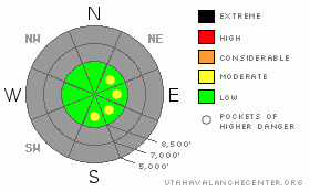
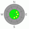
Danger Rose Tutorial
|
Currently with very little snow on the ground, there is generally a LOW danger on upper elevation slopes, with small and isolated wind slab avalanches possible. The danger may rise to MODERATE in pockets on drifted slopes at the highest elevations of the Bear River Range with more accumulation over the next few days. |
|
|
CURRENT CONDITIONS |

|
Looks like 4 to 6 inches of new snow on upper elevation slopes from yesterday's storm. Preexisting melt-freeze snow from October at upper elevations is shallow and quite solid, and it will act as a nice base for early season play on select slopes with smooth ground surfaces. |
|
|
RECENT ACTIVITY |
|
|
|
THREAT #1 |

|
| WHERE |
PROBABILITY |
SIZE |
TREND |
|
|
|
|
| |
|
|
Over the next
72 hours.
|
|
|
You might find a few small fresh wind slabs in the 1 foot-deep range at the highest elevations in the Bear River Range. These could become problematic in complex terrain, and you should avoid steep drifted slopes and be wary around around the highest ridge lines... |
|
|
THREAT #2 |

|
| WHERE |
PROBABILITY |
SIZE |
TREND |
|
|
|
|
| |
|
|
Over the next
24
hours.
|
|
|
Good idea as the season begins to dust off the gear, put new batteries in the beacon, and do a couple dry refresher practice drills just to keep your skills sharp.... |
|
|
MOUNTAIN WEATHER |

|
We’ll see continued cool and wintery weather into the weekend, with small amounts of accumulating snowfall at times...Temperatures should remain fairly cold at upper elevations until warm, pre-frontal air arrives on around Monday. |
|
|
GENERAL ANNOUNCEMENTS |
We will be issuing intermittent avalanche advisories as conditions change.
Our web site is now formatted for iPhone. You can also download a free iPhone application from Canyon Sports to display the Bottom Line. Search for Utah Avalanche on the Apple's iPhone Apps page or in iTunes.
If you want to get this avalanche advisory e-mailed to you daily click HERE.
For a text only version, the link is on the left side bar, near the top.
Donate to your favorite non-profit – The Friends of the Utah Avalanche Center. The UAC depends on contributions from users like you to support our work. To find out more about how you can support our efforts to continue providing the avalanche forecasting and education that you expect please visit our Friends page.
We appreciate avalanche and snow observations. If there’s something we should know about give us a call at (435-)755-3638 or 1-800-662-4140, or email us at uac@utahavalanchecenter.org. (Fax 801-524-6301).
The information in this advisory is from the U.S. Forest Service, which is solely responsible for its content. This advisory describes general avalanche conditions and local variations always occur. |
|
|
This information does not apply to developed ski areas or highways where avalanche control is normally done. This advisory is from the U.S.D.A. Forest Service, which is solely responsible for its content. This advisory describes general avalanche conditions and local variations always occur. |
|
This advisory provided by the USDA Forest Service, in partnership with:
The Friends of the Utah Avalanche Center, Utah Division of State Parks and Recreation, Utah Division of Emergency Management, Salt Lake County, Salt Lake Unified Fire Authority and the friends of the La Sal Avalanche Center. See our Sponsors Page for a complete list. |
