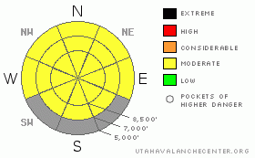
BOTTOM LINE
Danger by aspect and elevation on slopes approaching 35° or steeper.
(click HERE for tomorrow's danger rating)
|
Danger Rose Tutorial
|
There is a MODERATE danger in the backcountry, and you still might trigger wet avalanches on a few very steep slopes even in today's cooler weather. Accumulating snow and wind today may create a few shallow and manageable wind slabs in exposed upper elevation lee terrain.
You should evaluate the snow and terrain carefully and continue to use good travel habits..... |
|
|
CURRENT CONDITIONS |

|
Cooler temperatures and cloud cover should slow the meltdown and help with the slushy snow situation in the backcountry. The Tony Grove Snotel reports 80 inches of total snow still on the ground at 8400' containing 103% of average water for the date. |
|
|
RECENT ACTIVITY |

|
We noticed several more wet avalanches in the backcountry from the very warm days at the beginning of the week. Most obvious were the avalanches in the Wellsville Mountain Wilderness. A wet avalanche, likely initiated by a broad cornice fall, in North Shumway Canyon ran close to 3000 vertical feet, and another in Old Logway came down to Maple Bench...
There were also numerous wet avalanches reported in the Wasatch Range, with a giant glide avalanche Tuesday in Stairs Gulch topping the list.... |
|
|
THREAT #1 |

|
| WHERE |
PROBABILITY |
SIZE |
TREND |

|
|
|
|
| |
|
|
Over the next
24
hours.
|
|
|
The danger of wet avalanches will continue to be a threat today, and cooling this weekend will gradually reduce the danger of wet avalanches. |
|
|
THREAT #2 |

|
| WHERE |
PROBABILITY |
SIZE |
TREND |

|
|
|
|
| |
|
|
Over the next
24
hours.
|
|
|
Strongish northwest winds today at upper elevations will rapidly drift any accumulating snow into shallow wind slabs...These will likely be fairly small and manageable, but more snowfall than expected and continuing winds could increase the danger. |
|
|
MOUNTAIN WEATHER |

|
A few inches may accumulate at upper elevations today under a breezy northwest flow. Windy conditions will diminish somewhat by this evening and another inch or so of accumulation is possible overnight. Snow will continue tomorrow, but it doesn't look like we'll get a whole lot....Snow showers and cooler weather will be in play for the next few days, and into early next week....At least mountain temperatures should dip well below freezing for the next several nights, which will help stabilize the slushy snow. |
|
|
GENERAL ANNOUNCEMENTS |
Our "Know before You Go" video is available online..... (click HERE to watch it)
Please let us know what you're seeing in the backcountry, especially if you see or trigger an avalanche, by leaving us a message at (435-)755-3638 or 1-800-662-4140. Or, you can always e-mail us at uac@utahavalanchecenter.org. . Your observations are very important for our program.....
The Utah Avalanche Center depends on contributions from users like you to support our work.
This will be my last advisory for the season....Thanks for your support and observations.
This advisory is from the U.S.D.A. Forest Service, which is solely responsible for its content. This advisory describes general avalanche conditions and local variations always occur. |
|
|
This information does not apply to developed ski areas or highways where avalanche control is normally done. This advisory is from the U.S.D.A. Forest Service, which is solely responsible for its content. This advisory describes general avalanche conditions and local variations always occur. |
|
This advisory provided by the USDA Forest Service, in partnership with:
The Friends of the Utah Avalanche Center, Utah Division of State Parks and Recreation, Utah Division of Emergency Management, Salt Lake County, Salt Lake Unified Fire Authority and the friends of the La Sal Avalanche Center. See our Sponsors Page for a complete list. |
