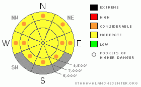
BOTTOM LINE
Danger by aspect and elevation on slopes approaching 35° or steeper.
(click HERE for tomorrow's danger rating)
|
Danger Rose Tutorial
|
There is a MODERATE danger in the backcountry today, meaning dangerous avalanche conditions exist in some areas. You could trigger sizable loose wet avalanches on very steep slopes with saturated fresh snow...The danger of wet avalanches will rise today with daytime heating and remain or increase on some slopes with seasonal and solar warming over the weekend. Some natural wet avalanches may occur in the midday heat. With this probability in mind, I am adding a few pockets of CONSIDERABLE to the danger rose....
Evaluate the snow and terrain carefully and continue to use good travel habits. |
|
|
CURRENT CONDITIONS |

|
We found fun north-coast powder conditions yesterday in the somewhat heavy and pink hued new snow. The storm deposited desert dust, swept up from lower elevation (no longer snow covered) areas far to our south, within the new snow and the heavily draped landscape looked pretty strange yesterday, especially with tinted goggle lenses...
The Tony Grove Snotel reports about 10 inches of new snow with 1.6 inches of water in the past 72 hours. There's 101 inches of total snow on the ground at 8400' containing 111% of average water. We found similar amounts of new snow up in Providence Canyon yesterday. It's a bit lighter and deeper at higher elevations across the region...... |
|
|
RECENT ACTIVITY |

|
Snow safety crews in the Wasatch yesterday reported some sizable soft wind slab and loose wet activity.....
Locally, I easily triggered sizable loose wet avalanches in Miller's Bowl, (north facing @ 8500'), just south of Tony Grove Lake on Wednesday. (4-15-09 PHOTOS) Yesterday, we triggered similar wet point-release avalanches on steep slopes in lower First Waterfall Hollow and encountered some sizable fresh natural debris just above the gravel pit area on north and northeast facing slopes at around 7000'. |
|
|
THREAT #1 |

|
| WHERE |
PROBABILITY |
SIZE |
TREND |
|
|
|
|
| |
|
|
Over the next
24
hours.
|
|
|
Wet avalanches involving saturated new snow are probable again today on very steep slopes. The danger of wet avalanches will continue to be a threat into the weekend.... Fresh snow quickly becomes sensitive this time of year with initial heating, and wet surface sluffs can entrain lots of heavy snow quickly. Daytime warming today and into the weekend will cause an increasing danger, and we should wisely decide to move off of and out from under steep slopes with saturated fresh snow. |
|
|
THREAT #2 |

|
| WHERE |
PROBABILITY |
SIZE |
TREND |

|
|
|
|
| |
|
|
Over the next
24
hours.
|
|
|
You might trigger lingering wind slabs, soft slabs, or cornice falls on very steep slopes in exposed upper elevation terrain...Winds during this storm had a little easterly component at times, and you might find stubborn wind slabs in somewhat unusual places up high.... |
|
|
MOUNTAIN WEATHER |

|
Expect mostly cloudy, but warming conditions, with a good chance of snow showers today and tomorrow. A calm wind today and tonight will be fairly light tomorrow from the northwest. Forecast high temperatures climb from the mid thirties today to around 40 tomorrow and near 50 on Sunday. Expect sunny and warm weather on Sunday and through the first half of next week. |
|
|
GENERAL ANNOUNCEMENTS |
Our "Know before You Go" video is available online..... (click HERE to watch it)
Please let us know what you're seeing in the backcountry, especially if you see or trigger an avalanche, by leaving us a message at (435-)755-3638 or 1-800-662-4140. Or, you can always e-mail us at uac@utahavalanchecenter.org. . Your observations are very important for our program.....
The Utah Avalanche Center depends on contributions from users like you to support our work.
I will be issuing intermittent and weekend advisories through the rest of April..... I will update this advisory early next week....
This advisory is from the U.S.D.A. Forest Service, which is solely responsible for its content. This advisory describes general avalanche conditions and local variations always occur. |
|
|
This information does not apply to developed ski areas or highways where avalanche control is normally done. This advisory is from the U.S.D.A. Forest Service, which is solely responsible for its content. This advisory describes general avalanche conditions and local variations always occur. |
|
This advisory provided by the USDA Forest Service, in partnership with:
The Friends of the Utah Avalanche Center, Utah Division of State Parks and Recreation, Utah Division of Emergency Management, Salt Lake County, Salt Lake Unified Fire Authority and the friends of the La Sal Avalanche Center. See our Sponsors Page for a complete list. |
