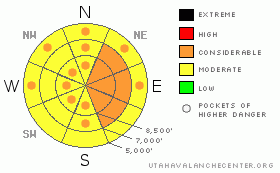
BOTTOM LINE
Danger by aspect and elevation on slopes approaching 35° or steeper.
(click HERE for tomorrow's danger rating)
|
Danger Rose Tutorial
|
There is a CONSIDERABLE danger in the backcountry, and dangerous triggered stiff or hard wind slab avalanches are probable on slopes steeper than about 35 degrees in many areas this morning. The danger is greatest on exposed upper elevation slopes facing the eastern half of the compass. Dangerous avalanche conditions may linger on some steep slopes with significant deposits of wind-drifted snow. Warming could cause an increasing danger of wet avalanches, and avalanches will be likely on steep slopes with saturated fresh surface snow. Continue to avoid and stay out from under huge and often deceitful ridge-top cornices, which were built out again significantly in the past couple days...
Use conservative decision making, careful route finding, and good travel habits. Training and experience are essential..... |
|
|
CURRENT CONDITIONS |

|
Looks like we missed out on most of the snow from this storm, with only a couple inches reported at the Tony Grove Snotel at 8400' containing .3 inches of water equivalent gain in the last 24 hrs. The remote depth sensor, meanwhile, shows only 1.5 inches of new snow...The station reports a snow total of 111 inches containing 105% of normal water content for the date. The wind sensor at the Campbell Scientific weather station at 9700' on Logan Peak reports a 5 to 10 mph north-northwest wind this morning, and it's 15 degrees.
After officially closing last weekend, Beaver Mountain will open today and tomorrow as a special bonus for season pass holders and local skiers... |
|
|
RECENT ACTIVITY |

|
Snow safety personnel up at Powder Mountain report triggering a couple good sized stiff wind slab avalanches yesterday on east and southeast facing slopes....
I observed several good sized natural wind slab avalanches in the Wellsville Range, which occurred overnight on March 31st. I went up and looked at a couple that were triggered by very large cornice falls. These stepped down into persistent buried weak layers and ran well over 2000 vertical feet down onto Maple Bench.
(4-1-09 PHOTOS) |
|
|
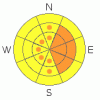
THREAT #1 |

|
| WHERE |
PROBABILITY |
SIZE |
TREND |
|
|
|
|
| |
|
|
Over the next
24
hours.
|
|
|
Strong winds all day long yesterday built stiff wind slabs and extended overhangs on cornices. (4-2-09 Photos).
I triggered several shooting cracks and a couple small wind slabs yesterday, and they were popping out pretty easily, with a clean shear on feathery surface hoar. Also, we received reports of audible collapses or whoomphing noises from the far southern Bear River Range. These heart stopping noises signal instability and often the existence of a buried persistent weak layer.... There are now actually a few different buried weak layers that could produce deeper releases in the Logan Area. I've found potentially persistent weak layers consisting of small near surface facets just above the hard melt-freeze crust from the warm spell two weeks ago, thin layers of airy graupel, and now a clean shear on a recent storm interface with surface hoar.
You probably could trigger stiff or hard wind slab avalanches on steep drifted slopes in many areas. |
|
|
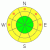
THREAT #2 |

|
| WHERE |
PROBABILITY |
SIZE |
TREND |
|
|
|
|
| |
|
|
Over the next
24
hours.
|
|
|
Warm overnight temperatures, rain, seasonally common direct solar warming, and/or greenhousing could cause lower and mid-elevation snow to become saturated. If this is the case, loose wet avalanches involving moist new snow will become likely on steep slopes. Fresh snow can become saturated and unstable very quickly this time of year. |
|
|
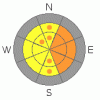
THREAT #3 |

|
| WHERE |
PROBABILITY |
SIZE |
TREND |
|
|
|
|
| |
|
|
Over the next
24
hours.
|
|
|
Continue to avoid and stay out from under huge ridge-top cornices...Some of these deceitful monsters, having been built out again hugely in the past few days, could be sensitive to your weight today. Cornices often break further back and/or wider than expected... Many of the local cornices are now way too big to mess around with, even on belay.
(3-28-09 PHOTO) |
|
|
MOUNTAIN WEATHER |

|
Well last night's storm went well to the south of us, after depositing only a couple inches in the Bear River Range....Snow showers will diminish today and we could see some clearing today....Another wave of potentially heavy snowfall is expected tonight into early tomorrow morning, with 6 inches of accumulation possible at upper elevations... Looks like most of the storm energy will be off to our south in the next couple days.
Expect warming conditions and a resumption of the melt early next week...
|
|
|
GENERAL ANNOUNCEMENTS |
Our "Know before You Go" video is available online..... (click HERE to watch it)
Please let us know what you're seeing in the backcountry, especially if you see or trigger an avalanche, by leaving us a message at (435-)755-3638 or 1-800-662-4140. Or, you can always e-mail us at uac@utahavalanchecenter.org. . Your observations are very important for our program.....
This advisory is from the U.S.D.A. Forest Service, which is solely responsible for its content. This advisory describes general avalanche conditions and local variations always occur.
The Utah Avalanche Center depends on contributions from users like you to support our work.
I will update this advisory by around 7:30 tomorrow morning. This will be the last regularly updated advisory of the season, and I will be leaving town for several days for spring break with the family. I will, however, resume intermittent and weekend advisories through the rest of April..... |
|
|
This information does not apply to developed ski areas or highways where avalanche control is normally done. This advisory is from the U.S.D.A. Forest Service, which is solely responsible for its content. This advisory describes general avalanche conditions and local variations always occur. |
|
This advisory provided by the USDA Forest Service, in partnership with:
The Friends of the Utah Avalanche Center, Utah Division of State Parks and Recreation, Utah Division of Emergency Management, Salt Lake County, Salt Lake Unified Fire Authority and the friends of the La Sal Avalanche Center. See our Sponsors Page for a complete list. |
