BOTTOM LINE
Danger by aspect and elevation on slopes approaching 35° or steeper.
(click HERE for tomorrow's danger rating)
|
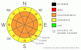
Danger Rose Tutorial
|
There is a CONSIDERABLE danger in the backcountry, and dangerous triggered wind slab and new snow avalanches are probable on slopes steeper than about 35 degrees in many areas this morning. Some natural avalanches are possible... As the storm exits the region today, settlement within the new snow should rapidly diminish the danger, but dangerous avalanche conditions will likely linger, mainly on steep slopes with significant deposits of wind-drifted snow. Seasonally common direct solar warming or greenhousing could cause an increasing danger of wet avalanches on steep slopes with saturated fresh surface snow. Continue to avoid and stay out from under huge and often deceitful ridge-top cornices, which were built out again significantly overnight...
Don't let the snow make a fool out of you today, as dangerous avalanche conditions exist in the backcountry....Seriously, use conservative decision making, careful route finding, and good travel habits. Training and experience are essential..... |
|
|
CURRENT CONDITIONS |

|
The Bear River Range has done well again, with significant snowfall, especially compared to other areas in the state. Perhaps just a cruel April Fools joke, but today's snow appears fairly heavy or dense. The Tony Grove Snotel at 8400' reports 1.4 inches of water equivalent gain in the last 24 hrs. The remote depth sensor, meanwhile, shows only 8.5 inches of new snow (including settlement in both the new and the old snow)....The station reports a season high snow total of 115 inches containing 105% of normal water content for the date. The wind sensor at the Campbell Scientific weather station at 9700' on Logan Peak reports a 10 mph northwest wind this morning, and it's 7 degrees. |
|
|
RECENT ACTIVITY |

|
The snow safety crew from one of the ski areas in the Ogden Area reported yesterday triggering a fairly large wind slab avalanche with explosives on an upper elevation northeast facing slope. Other backcountry observations from the Wasatch include several small and quite manageable triggered wind slabs....
I was able to get some loose dry snow moving on a steep lower elevation slope yesterday mid-morning, and a party passing through the same area a couple hours later reported some wet activity. |
|
|
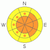
THREAT #1 |

|
| WHERE |
PROBABILITY |
SIZE |
TREND |
|
|
|
|
| |
|
|
Over the next
24
hours.
|
|
|
Winds on Logan Peak diminished somewhat overnight and switched around from the northwest, a direction that appears to favor the Central Bear River Range more than the Logan Peak Area. But with all the fresh powder available for transport, last night's moderating winds were perfect for building sizable soft slabs in numerous exposed avalanche starting zones, especially at upper elevations and near ridge-lines. "Blustery" conditions, with northwest winds are forecast to continue today.
You probably could trigger fresh wind slab avalanches on steep drifted slopes in many areas. |
|
|
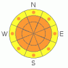
THREAT #2 |

|
| WHERE |
PROBABILITY |
SIZE |
TREND |
|
|
|
|
| |
|
|
Over the next
24
hours.
|
|
|
Triggered manageable, and maybe some not so manageable, loose and soft slab avalanches consisting of new snow are probable this morning on slopes steeper than about 35 degrees...Some natural activity is possible. I expect the danger to gradually moderate throughout the day, with snow settlement rapidly healing most new snow instability.
Seasonally common direct solar warming or greenhousing could cause lower elevation fresh surface snow to become saturated. If this is the case, loose wet avalanches involving moist new snow will be likely on steep slopes. |
|
|
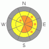
THREAT #3 |

|
| WHERE |
PROBABILITY |
SIZE |
TREND |
|
|
|
|
| |
|
|
Over the next
24
hours.
|
|
|
Avoid and stay out from under huge ridge-top cornices...These deceitful monsters, having been built out again in a big way, are quite likely to be sensitive to your weight today. Cornices often break further back and/or wider than expected... Many of the local cornices are now way too big to mess around with, even on belay.
(3-26-09 PHOTOS) (3-28-09 PHOTO) |
|
|
MOUNTAIN WEATHER |

|
After periods of heavy snowfall early this morning, we'll see showery conditions with lots of cloud cover and continuing northwest winds today, with temperatures peaking at around 22 degrees at 9000'. The next springtime Pacific storm will start to impact our area tomorrow. Expect snowfall to initiate sometime after noon and intensify, with strengthening west and southwest winds into Thursday night. Storminess should continue into the weekend...Another productive round of winter-like and snowy weather is expected early next week.... |
|
|
GENERAL ANNOUNCEMENTS |
Our "Know before You Go" video is available online..... (click HERE to watch it)
Please let us know what you're seeing in the backcountry, especially if you see or trigger an avalanche, by leaving us a message at (435-)755-3638 or 1-800-662-4140. Or, you can always e-mail us at uac@utahavalanchecenter.org. . Your observations are very important for our program.....
This advisory is from the U.S.D.A. Forest Service, which is solely responsible for its content. This advisory describes general avalanche conditions and local variations always occur.
The Utah Avalanche Center depends on contributions from users like you to support our work.
I will update this advisory by around 7:30 Friday morning. |
|
|
This information does not apply to developed ski areas or highways where avalanche control is normally done. This advisory is from the U.S.D.A. Forest Service, which is solely responsible for its content. This advisory describes general avalanche conditions and local variations always occur. |
|
This advisory provided by the USDA Forest Service, in partnership with:
The Friends of the Utah Avalanche Center, Utah Division of State Parks and Recreation, Utah Division of Emergency Management, Salt Lake County, Salt Lake Unified Fire Authority and the friends of the La Sal Avalanche Center. See our Sponsors Page for a complete list. |
