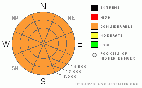
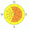
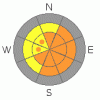
BOTTOM LINE
Danger by aspect and elevation on slopes approaching 35° or steeper.
(click HERE for tomorrow's danger rating)
|
Danger Rose Tutorial
|
There is a CONSIDERABLE danger in the backcountry, and dangerous triggered wind slab and new snow avalanches are probable on slopes steeper than about 35 degrees in many areas this morning. Some natural avalanches are possible... As the storm exits the region today, settlement of the new snow will gradually diminish the danger, but dangerous avalanche conditions will likely linger in some terrain features, mainly on steep slopes with significant deposits of wind drifted snow. Avoid and stay out from under huge and often deceitful ridge-top cornices...
Use conservative decision making, careful route finding, and good travel habits. Training and experience are essential..... |
|
|
CURRENT CONDITIONS |

|
The Tony Grove Snotel at 8400' reports 1.7 inches of water equivalent gain in the last 24 hrs in 23 inches of settled new powder snow....The station reports a season high snow total of 114 inches containing 101% of normal water content for the date. The wind sensor at the Campbell Scientific weather station at 9700' on Logan Peak reports a 20 to 25 mph north-northwest wind this morning, with a gust of 41 mph recorded earlier, and it's 5 degrees. |
|
|
RECENT ACTIVITY |

|
Locally, one party reported triggering easily managed shallow loose dry snow avalanches or sluffs yesterday afternoon on steep upper elevation slopes in Providence Canyon... On Saturday, a member of my party triggered a small wind slab on the gully wall in lower Music Note in Mill Hollow. (3-28-09 PHOTOS), Another small triggered wind slab was reported from the Steam Mill Peak Area....And, I observed evidence of numerous loose wet avalanches by evening due to the warm air temperatures, mostly on normally shady lower elevation slopes... |
|
|
THREAT #1 |

|
| WHERE |
PROBABILITY |
SIZE |
TREND |
|
|
|
|
| |
|
|
Over the next
24
hours.
|
|
|
Very strong west and southwest pre-frontal winds Saturday night and yesterday morning built stiff hard slabs on exposed lee slopes and in and around terrain features like gullies, sub-ridges, and cliff bands. Winds diminished after yesterday's energetic cold front passed and switched around from the northwest...Given all the fresh powder available for transport, last night's moderate winds were probably perfect for building sizable soft slabs in numerous exposed avalanche starting zones, especially at upper elevations and near ridge-lines. A northerly wind picked up a little in the last couple hours this morning.
You probably could trigger sizable soft wind slab avalanches this morning in many areas. I expect the danger to gradually diminish throughout the day as the storm exits the region, with snow settlement. |
|
|
THREAT #2 |

|
| WHERE |
PROBABILITY |
SIZE |
TREND |

|
|
|
|
| |
|
|
Over the next
8 hours.
|
|
|
Triggered manageable, (and maybe some not so manageable,) loose and soft slab avalanches consisting of new snow are probable this morning on slopes steeper than about 35 degrees...Some natural activity is possible. This threat will moderate fairly quickly with settlement today as well.... |
|
|
THREAT #3 |

|
| WHERE |
PROBABILITY |
SIZE |
TREND |
|
|
|
|
| |
|
|
Over the next
24
hours.
|
|
|
Avoid and stay out from under huge ridge-top cornices...These deceitful monsters, having been built out anew BIG TIME, are likely to be sensitive to your weight today. Cornices often break further back and/or wider than expected...Many of the local cornices are now way too big to mess around with.
(3-26-09 PHOTOS) (3-28-09 PHOTO) |
|
|
MOUNTAIN WEATHER |

|
We'll see showery conditions with lots of cloud cover and continuing moderate northwest winds today, with temperatures peaking at around 22 degrees at 9000'. The next springtime Pacific storm will start to impact our area tomorrow. Expect snowfall to initiate sometime after noon and intensify, with strengthening west winds on Tuesday night. Storminess should continue into Wednesday....Another productive round of winter-like and snowy weather is expected later in the week.... |
|
|
GENERAL ANNOUNCEMENTS |
Our "Know before You Go" video is available online..... (click HERE to watch it)
Please let us know what you're seeing in the backcountry, especially if you see or trigger an avalanche, by leaving us a message at (435-)755-3638 or 1-800-662-4140. Or, you can always e-mail us at uac@utahavalanchecenter.org. . Your observations are very important for our program.....
This advisory is from the U.S.D.A. Forest Service, which is solely responsible for its content. This advisory describes general avalanche conditions and local variations always occur.
The Utah Avalanche Center depends on contributions from users like you to support our work.
I will update this advisory by around 7:30 Wednesday morning. |
|
|
This information does not apply to developed ski areas or highways where avalanche control is normally done. This advisory is from the U.S.D.A. Forest Service, which is solely responsible for its content. This advisory describes general avalanche conditions and local variations always occur. |
|
This advisory provided by the USDA Forest Service, in partnership with:
The Friends of the Utah Avalanche Center, Utah Division of State Parks and Recreation, Utah Division of Emergency Management, Salt Lake County, Salt Lake Unified Fire Authority and the friends of the La Sal Avalanche Center. See our Sponsors Page for a complete list. |
