BOTTOM LINE
Danger by aspect and elevation on slopes approaching 35° or steeper.
(click HERE for tomorrow's danger rating)
|
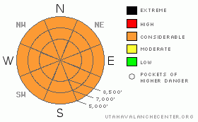
Danger Rose Tutorial
|
The overall danger will rise to CONSIDERABLE in the backcountry with today's winter storm...This morning, you could trigger dangerous stiff wind slab avalanches on steep exposed slopes and in and around terrain features like gullies, sub-ridges, and cliff bands. The danger of storm snow avalanches will likely increase drastically throughout the day, and natural loose and soft slab avalanches are a good possibility on some slopes steeper than about 35 degrees, especially during periods of exceptionally heavy snowfall. Continue to avoid and stay out from under huge and often deceitful ridge-top cornices...
Use conservative decision making, careful route finding, and good travel habits. Training and experience are essential..... |
|
|
CURRENT CONDITIONS |

|
The National Weather Service has issue a Winter Storm Warning for the mountains, starting now and extending through early tomorrow morning. The nice snow from last week is now either sun-crusted or wind-hammered on most slopes, but the next moist and energetic looking spring-time Pacific storm is already upon us this morning.
The Tony Grove Snotel at 8400' reports a little over 5 inches of water equivalent gain since last Sunday....The wind sensor at the Campbell Scientific weather station at 9700' on Logan Peak reports a 35 mph west-southwest wind this morning, with a gust of 73 mph recorded earlier, and it's 23 degrees. I'm reading 34 degrees up at Tony Grove after a warm night, where, with 92 inches on the total snow-stake, the station sits with 97% of normal water content for the date. |
|
|
RECENT ACTIVITY |

|
Backcountry skiers yesterday triggered a couple more wind slabs and wet avalanches as they pushed into steeper terrain in the Wasatch Range.
Locally, a member of my party triggered a small wind slab on the gully wall in lower Music Note in Mill Hollow. (3-28-09 PHOTOS), Another small triggered wind slab was reported from the Steam Mill Peak Area....I observed evidence of numerous loose wet avalanches by yesterday evening, mostly on normally shady lower elevation slopes... |
|
|
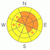
THREAT #1 |

|
| WHERE |
PROBABILITY |
SIZE |
TREND |
|
|
|
|
| |
|
|
Over the next
24
hours.
|
|
|
Very strong west and southwest winds overnight built stiff slabs on lee slopes and in and around terrain features like gullies sub-ridges and rock bands. Most of the transportable snow was stashed on sheltered shady slopes at upper and mid elevations.
Continuing strong winds during today's potentially heavy snowfall will quickly build fresh wind slabs over wide lee slope deposition areas and in avalanche starting zones... |
|
|
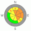
THREAT #2 |

|
| WHERE |
PROBABILITY |
SIZE |
TREND |

|
|
|
|
| |
|
|
Over the next
8 hours.
|
|
|
Rapidly accumulating snow today will cause a rising danger on steep slopes in the backcountry. Natural soft slab and loose avalanches will be most likely during periods of intense or exceptionally heavy snowfall...Continued windy conditions will increase loading substantially in some lee slope areas....Triggered manageable as well as not so manageable avalanches will likely become probable on slopes steeper than about 35 degrees... |
|
|
THREAT #3 |

|
| WHERE |
PROBABILITY |
SIZE |
TREND |
|
|
|
|
| |
|
|
Over the next
24
hours.
|
|
|
Avoid and stay out from under huge ridge-top cornices...These, having been built out anew are still potentially sensitive to your weight, and today's strong wind and heavy snowfall won't help matters any.....
(3-26-09 PHOTOS) |
|
|
MOUNTAIN WEATHER |

|
Expect heavy snowfall and fairly strong westerly winds today, with accumulations of around a foot possible by this evening. Snowfall should continue into the night with strong west and northwest winds and another 4 to 6 inches of accumulation likely. Monday should bring snow showers and breezy contitions...Another storm will impact the region on Tuesday. |
|
|
GENERAL ANNOUNCEMENTS |
Our "Know before You Go" video is available online..... (click HERE to watch it)
Please let us know what you're seeing in the backcountry, especially if you see or trigger an avalanche, by leaving us a message at (435-)755-3638 or 1-800-662-4140. Or, you can always e-mail us at uac@utahavalanchecenter.org. . Your observations are very important for our program.....
This advisory is from the U.S.D.A. Forest Service, which is solely responsible for its content. This advisory describes general avalanche conditions and local variations always occur.
The Utah Avalanche Center depends on contributions from users like you to support our work.
I will update this advisory by around 7:30 Monday morning. |
|
|
This information does not apply to developed ski areas or highways where avalanche control is normally done. This advisory is from the U.S.D.A. Forest Service, which is solely responsible for its content. This advisory describes general avalanche conditions and local variations always occur. |
|
This advisory provided by the USDA Forest Service, in partnership with:
The Friends of the Utah Avalanche Center, Utah Division of State Parks and Recreation, Utah Division of Emergency Management, Salt Lake County, Salt Lake Unified Fire Authority and the friends of the La Sal Avalanche Center. See our Sponsors Page for a complete list. |
