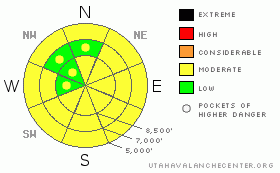
BOTTOM LINE
Danger by aspect and elevation on slopes approaching 35° or steeper.
(click HERE for tomorrow's danger rating)
|
Danger Rose Tutorial
|
There is a MODERATE danger in the backcountry, and you might trigger fresh or older wind slabs today on some drifted slopes steeper than about 35 degrees. ..Dangerous wet avalanche conditions also may develop on some steep slopes due to solar warming and potential greenhousing. Triggered and natural wet avalanches will become more likely with midday heating on any slope steeper than about 35 degrees with saturated surface snow. Continue to avoid and stay out from under huge and often deceitful ridge-top cornices...
Evaluate the snow and terrain carefully and use good travel habits. |
|
|
CURRENT CONDITIONS |

|
Even though we got tons of new snow over the last week, trail breaking and turning conditions felt more like a half-a-foot than 4 feet. This was not the really the case on the sled, and the deep, bottomless-feeling snow was a bit of a challenge.
The Tony Grove Snotel at 8400' reports 5 inches of water equivalent gain since last Sunday....The wind sensor at the Campbell Scientific weather station at 9700' on Logan Peak reports a 25 mph west-northwest wind this morning and it's 17 degrees. Reading 24 degrees up at Tony Grove, where, with 97 inches on the total snow-stake, the station sits with 98% of normal water content for the date. |
|
|
RECENT ACTIVITY |

|
Backcountry skiers yesterday triggered a couple small wind slabs in the Wasatch Range, and ski area snow safety crews also were able to trigger a few lingering wind slabs with explosives.
Locally, I've received only few reports from the backcountry, and nobody reported any significant or fresh avalanches....Since the Logan Canyon trail-heads were packed with sledders' rigs yesterday, I can only assume you tested a good number of steep slopes and found mostly stable conditions.....
(3-26-09 PHOTOS) |
|
|
THREAT #1 |

|
| WHERE |
PROBABILITY |
SIZE |
TREND |

|
|
|
|
| |
|
|
Over the next
24
hours.
|
|
|
You might trigger freshly formed and older wind slabs on some drifted slopes steeper than about 35 degrees at any elevation. Wind slabs built during Wednesday's storm may, in a few cases, be resting on persistent weak layers and could still be sensitive to human triggers today. I haven't been able to find any surviving weak layers that are noticeably weak or widespread. But in isolated areas, you might find graupel layers, which are somewhat notorious for causing slab avalanches around here this time of year.....Also, on many slopes, small faceted crystals formed just above or below the saturated dusty snow that worked it's way through melting and freezing back to the surface a week ago in many areas. Isolated slab avalanches stepping down into old snow are possible on very steep, drifted slopes. In a worst-case scenario, you might trigger dangerous slab avalanches in the 2 to 3+ foot deep range. |
|
|
THREAT #2 |

|
| WHERE |
PROBABILITY |
SIZE |
TREND |
|
|
|
|
| |
|
|
Over the next
10 hours.
|
|
|
Cloud cover overnight kept some heat in the atmosphere, and mountain temperatures this morning are about 10 degrees warmer than yesterday. But it's still fairly cool and increasing cloud cover is likely to keep things from heating up too much...But this time of year, rapid solar warming can happen almost any day, and cloud cover can trap heat like a greenhouse....Wet avalanches are possible on any steep slope where the surface snow becomes saturated. ...Wind slabs or cornice falls releasing in dry snow at upper elevations could entrain wet snow in descent and become larger and more dangerous avalanches lower down the slope. |
|
|
THREAT #3 |

|
| WHERE |
PROBABILITY |
SIZE |
TREND |
|
|
|
|
| |
|
|
Over the next
24
hours.
|
|
|
Avoid and stay out from under huge ridge-top cornices...These, having been built out anew are still potentially sensitive to your weight, and warming today won't help matters.....
(3-26-09 PHOTOS) |
|
|
MOUNTAIN WEATHER |

|
We'll see mostly cloudy and mild conditions today, as the short-lived high pressure system begins to be pushed eastward. As the next cold Pacific storm approaches, expect increasing cloud cover and southwest winds today and this evening....Snowfall should begin overnight with fairly stout southwest winds and continue through much of tomorrow, with 4 to 8 inches of accumulation forecast by evening. The coming week will bring a couple more spring storms. |
|
|
GENERAL ANNOUNCEMENTS |
Our "Know before You Go" video is available online..... (click HERE to watch it)
Please let us know what you're seeing in the backcountry, especially if you see or trigger an avalanche, by leaving us a message at (435-)755-3638 or 1-800-662-4140. Or, you can always e-mail us at uac@utahavalanchecenter.org. . Your observations are very important for our program.....
This advisory is from the U.S.D.A. Forest Service, which is solely responsible for its content. This advisory describes general avalanche conditions and local variations always occur.
The Utah Avalanche Center depends on contributions from users like you to support our work.
I will update this advisory by around 7:30 Monday morning. |
|
|
This information does not apply to developed ski areas or highways where avalanche control is normally done. This advisory is from the U.S.D.A. Forest Service, which is solely responsible for its content. This advisory describes general avalanche conditions and local variations always occur. |
|
This advisory provided by the USDA Forest Service, in partnership with:
The Friends of the Utah Avalanche Center, Utah Division of State Parks and Recreation, Utah Division of Emergency Management, Salt Lake County, Salt Lake Unified Fire Authority and the friends of the La Sal Avalanche Center. See our Sponsors Page for a complete list. |
