AVALANCHE WARNING »
Dangerous avalanche conditions are occuring or are imminent.
Backcountry travel in avalanche terrain is not recommended.
|
 |
Notice: THE AVALANCHE WARNING HAS BEEN EXPANDED TO COVER ALL THE WASATCH MOUNTAINS FROM THE IDAHO BORDER SOUTH TO US HIGHWAY ROUTE 6. TWO TO THREE FEET OF NEW SNOW AND STRONG WINDS HAVE CREATED A HIGH AVALANCHE DANGER. BOTH NATURAL AND HUMAN TRIGGERED AVALANCHES ARE CERTAIN ON STEEP SLOPES. BACKCOUNTRY TRAVEL IS NOT RECOMMENDED. |
|
|
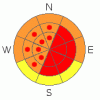
BOTTOM LINE
Danger by aspect and elevation on slopes approaching 35° or steeper.
(click HERE for tomorrow's danger rating)
|

Danger Rose Tutorial
|
There is a HIGH danger in the backcountry, and very dangerous natural and triggered avalanches are likely today and presently occurring in some areas this morning. Large wind slab and dangerous new snow avalanches are likely on slopes approaching 35 degrees or steeper with significant deposits of new or especially drifted new snow. Travel in avalanche terrain is not recommended...
You should avoid and stay out from under all steep slopes and obvious or historic avalanche paths..... |
|
|
CURRENT CONDITIONS |

|
....With simply too much snow in the mountains and sustained and strong wind, our powerful and cold Pacific storm caused very dangerous avalanche conditions to develop yesterday and overnight, and backcountry travel is not recommended.
The Tony Grove Snotel at 8400' reports two-and-a-half inches of water equivalent in the past 24 hours, with 18+ inches showing on the remote depth sensor, despite obvious wind affects. The Ben Lomond Snotel recorded 3 inches of water and 19 inches of settled (or wind drifted) snow in the last 24 hours. The 8000', USUDoc Daniels Snotel near the Sinks Road showed 15 inches with 1.5 inches of water as of 11:00 last night........The wind sensor at the Campbell Scientific weather station at 9700' on Logan Peak shows a 10 mph north wind this morning after maintaining steady 15 mph averages from the northwest overnight. Once again my field observations proved that the Logan Peak wind sensor does not show northwest winds very well, as I encountered much stronger west and northwest winds and ridiculous amounts of drifting snow at all elevations yesterday in the Central Bear River Range.
It's a winter-like 9 degrees on Logan Peak and 17 at Tony Grove, where with 104 inches on the total snow-stake, the station sits with 98% of normal water content for the date. |
|
|
RECENT ACTIVITY |

|
Yesterday, Wasatch snow safety crews and a hardy handful of backcountry skiers triggered widespread sizable soft slab avalanches. Avalanche control produced a couple very large avalanches in exposed upper elevation terrain at an Ogden Area ski resort, and a sizable avalanche was remotely triggered by a ski-cut. Remote UDOTavalanche sensors report at least two large natural avalanches in Little Cottonwood Canyon running very early this morning.
Locally, I along with most other people who attempted to head into the high country yesterday were thwarted by very DEEP new snow and extensive and overwhelming drifting. No avalanches were reported from yesterday, but reports from Tuesday include several small fresh wind slabs, intentionally or "not unexpectedly" triggered. The largest of these was around 40' wide and 8" deep up in the Hell's Kitchen Area out of Franklin Basin, (3-24-09 PHOTOS). Other reports are from drifted mid-elevation slopes in lower Providence Canyon...One party mentioned triggering several ominous whoomphing noises or audible collapses at mid-elevations up in the Bunch Grass area. |
|
|
THREAT #1 |

|
| WHERE |
PROBABILITY |
SIZE |
TREND |
|
|
|
|
| |
|
|
Over the next
24
hours.
|
|
|
Strong west and northwest winds occurring during periods of rapidly accumulating snowfall yesterday and overnight drifted tons of snow onto steep slopes and avalanche starting zones. Significant and dangerous natural and triggered wind slab avalanches are occurring this morning across the Northern Utah Mountains.
Avoid and stay clear of and out from under all steep drifted slopes, obvious and historic avalanche paths, and freshly rebuilt huge and deceitful ridge-top cornices..... |
|
|
THREAT #2 |

|
| WHERE |
PROBABILITY |
SIZE |
TREND |

|
|
|
|
| |
|
|
Over the next
24
hours.
|
|
|
Natural and triggered soft slab avalanches and sizable loose snow avalanches are likely today and occurring presently on slopes approaching 35 degrees or steeper with significant deposits (2 to 3 feet) of fresh and inverted new snow.... |
|
|
MOUNTAIN WEATHER |

|
Snowfall should taper off today, with a few more inches of accumulation likely first...Blustery and cold conditions will persist with a fairly strong and gusty north-northwest wind and forecast high mountain temperatures around 20 degrees. Wind will shift around from the north and east and calm down a bit with clearing overnight. Friday will be mostly sunny and a bit warmer.... Another cold Pacific storm is due to impact the region on Sunday..... |
|
|
GENERAL ANNOUNCEMENTS |
Our "Know before You Go" video is available online..... (click HERE to watch it)
Please let us know what you're seeing in the backcountry, especially if you see or trigger an avalanche, by leaving us a message at (435-)755-3638 or 1-800-662-4140. Or, you can always e-mail us at uac@utahavalanchecenter.org. . Your observations are very important for our program.....
This advisory is from the U.S.D.A. Forest Service, which is solely responsible for its content. This advisory describes general avalanche conditions and local variations always occur.
The Utah Avalanche Center depends on contributions from users like you to support our work.
I will update this advisory by around 7:30 Friday morning. |
|
|
This information does not apply to developed ski areas or highways where avalanche control is normally done. This advisory is from the U.S.D.A. Forest Service, which is solely responsible for its content. This advisory describes general avalanche conditions and local variations always occur. |
|
This advisory provided by the USDA Forest Service, in partnership with:
The Friends of the Utah Avalanche Center, Utah Division of State Parks and Recreation, Utah Division of Emergency Management, Salt Lake County, Salt Lake Unified Fire Authority and the friends of the La Sal Avalanche Center. See our Sponsors Page for a complete list. |
