AVALANCHE WARNING »
Dangerous avalanche conditions are occuring or are imminent.
Backcountry travel in avalanche terrain is not recommended.
|
 |
Notice:
THE AVALANCHE WARNING HAS BEEN EXPANDED TO COVER ALL THE WASATCH
MOUNTAINS FROM THE IDAHO BORDER SOUTH TO US HIGHWAY ROUTE 6. TWO
TO THREE FEET OF NEW SNOW AND STRONG WINDS HAVE CREATED A HIGH
AVALANCHE DANGER. BOTH NATURAL AND HUMAN TRIGGERED AVALANCHES ARE
CERTAIN ON STEEP SLOPES. BACKCOUNTRY TRAVEL IS NOT RECOMMENDED.
THIS WARNING DOES NOT INCLUDE SKI AREAS OR HIGHWAYS WHERE
AVALANCHE CONTROL IS NORMALLY DONE.
|
|
|
BOTTOM LINE
Danger by aspect and elevation on slopes approaching 35° or steeper.
(click HERE for tomorrow's danger rating)
|
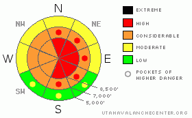
Danger Rose Tutorial
|
There is a CONSIDERABLE danger in the backcountry, and you are likely to trigger wind slab or sizable new snow avalanches on slopes steeper than about 35 degrees, most likely on lee slopes at upper elevations and in areas that receive significant deposits of drifted snow. Some natural avalanches are possible during periods of exceptionally heavy snowfall, or if the wind picks up significantly, and the danger is likely rise to HIGH in some areas and become more widespread during today's storm.
You should avoid and stay out from under steep drifted slopes and obvious or historic avalanche paths..... |
|
|
CURRENT CONDITIONS |

|
The Tony Grove Snotel reports another 4 or so inches by 2 am this morning with about .7 inches of water and a total of 90 inches on the ground. Beaver Mountain reads 8 inches with a chilly temp of 17 degrees. It is currently snowing in the valley and in the mountains. The Campbell Scientific weather station at 9700' on Logan Peak currently reports an overnight Northwest wind averaging in the low to mid-teens and it’s now 14 degrees.
The National Weather Service has issued a Winter Storm Warning for the northern and central Utah mountains until 4pm on Thursday. Forecast snow amounts range from 1 to 2 feet.
Travel in the backcountry yesterday was fairly easy except for climbing over the snow waves that had drifted onto the ridge-tops. We found deep powder riding conditions at mid and upper elevations in Providence Canyon |
|
|
RECENT ACTIVITY |

|
Observers across the Northern Utah backcountry report mostly manageable (generally small) triggered wind slab avalanches from yesterday. There were some larger, explosive triggered avalanches as well, involving drifted new snow.
Locally, reports from the backcountry include several small fresh wind slabs, intentionally or "not unexpectedly" triggered. The largest of these was around 40' wide and 8" deep up in the Hell's Kitchen Area out of Franklin Basin. Other reports are from drifted mid-elevation slopes in lower Providence Canyon...One party mentioned triggering several ominous woomphing noises or audible collapses up in the Bunch grass area. |
|
|
THREAT #1 |

|
| WHERE |
PROBABILITY |
SIZE |
TREND |
|
|
|
|
| |
|
|
Over the next
24
hours.
|
|
|
Moderate but steady northwest winds occurring during periods of accumulating snowfall overnight and this morning are drifting soft slabs onto steep lee slope deposition areas, especially in exposed upper elevation terrain. As ridge-top winds continue today, wind slabs will continue to get deeper and stiffer and so, much less manageable.
Triggered soft wind slabs consisting of new snow are likely today and older, stiffer slabs are possible on slopes steeper than about 35 degrees in exposed upper elevation areas with significant deposits of drifted snow. An increase or shift in winds could cause an increase in danger and a more widespread problem....
Avoid and stay clear of steep drifted slopes and huge and deceitful ridge-top cornices..... |
|
|
THREAT #2 |

|
| WHERE |
PROBABILITY |
SIZE |
TREND |

|
|
|
|
| |
|
|
Over the next
24
hours.
|
|
|
Periods of very heavy snowfall today could create a danger of natural new snow loose or slab avalanches. If it really starts dumping, be sure you're not under steep slopes or in a runout gully....Triggered and perhaps less manageable loose and soft slab avalanches are likely on steep slopes with significant deposits of new powder.... |
|
|
MOUNTAIN WEATHER |

|
If you aren’t ready to put away the fat toys, then this storm is for you. Snowfall will continue to be heavy throughout much of today and tonight in the Bear River Range as a moist northwest flow persists.
Winds will shift to the west and remain fairly moderate. The bulk of the storm should begin to dissipate by Thursday late morning. Another cold system will impact us on Sunday with moisture content still undecided. |
|
|
GENERAL ANNOUNCEMENTS |
|
Our "Know before You Go" video is available online..... (click HERE to watch it)
Please let us know what you're seeing in the backcountry, especially if you see or trigger an avalanche, by leaving us a message at (435-)755-3638 or 1-800-662-4140. Or, you can always e-mail us at uac@utahavalanchecenter.org. . Your observations are very important for our program.....
This advisory is from the U.S.D.A. Forest Service, which is solely responsible for its content. This advisory describes general avalanche conditions and local variations always occur.
The Utah Avalanche Center depends on contributions from users like you to support our work.
I will update this advisory by around 7:30 Friday morning. |
|
|
This information does not apply to developed ski areas or highways where avalanche control is normally done. This advisory is from the U.S.D.A. Forest Service, which is solely responsible for its content. This advisory describes general avalanche conditions and local variations always occur. |
|
This advisory provided by the USDA Forest Service, in partnership with:
The Friends of the Utah Avalanche Center, Utah Division of State Parks and Recreation, Utah Division of Emergency Management, Salt Lake County, Salt Lake Unified Fire Authority and the friends of the La Sal Avalanche Center. See our Sponsors Page for a complete list. |
