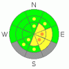
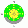
BOTTOM LINE
Danger by aspect and elevation on slopes approaching 35° or steeper.
(click HERE for tomorrow's danger rating)
|
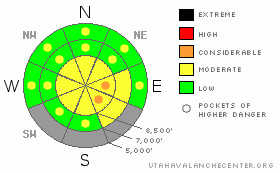
Danger Rose Tutorial
|
There is a MODERATE danger in the backcountry, and you are likely to trigger generally manageable soft wind slab or loose new snow avalanches on slopes steeper than about 35 degrees, most likely on lee slopes at upper elevations and in areas that received significant deposits (a foot or more) of new snow. Some natural avalanches consisting of new snow are possible during periods of exceptionally heavy snowfall, or if the wind picks up significantly, and the danger could become more widespread. I've added a couple pockets of CONSIDERABLE on upper elevation lee slopes to cover this possibility.
Evaluate the snow and terrain carefully and use good travel habits. |
|
|
CURRENT CONDITIONS |

|
The Tony Grove Snotel reports 11 inches of new snow in the last 24 hours, with 1 inch of water content and 83 inches of total snow on the ground. The remote depth sensor up at Beaver Mountain reads 7 inches, and I'm reading .6" of water at Franklin Basin, and .5" H2O at USU Doc Daniel (Sinks Road). But it looks like the southern part of the range and the Wellsvilles pretty much got skunked, at least so far, with Ben Lomond Peak Snotel showing a bit over an inch, and that early this morning.
The Campbell Scientific weather station at 9700' on Logan Peak currently reports a steady 15 mph northwest wind overnight and 13 degrees. |
|
|
RECENT ACTIVITY |

|
....I've been able to post a few photos of last week's wet avalanche activity on our Website: (LOGAN AREA PHOTOS)
Yesterday's storm brought much needed colder temperatures, and we won't have to worry about wet avalanches as much now that the saturated snow has frozen.... |
|
|
THREAT #1 |

|
| WHERE |
PROBABILITY |
SIZE |
TREND |
|
|
|
|
| |
|
|
Over the next
12 hours.
|
|
|
The steady northwest winds occurring during periods of accumulating snowfall overnight and this morning are drifting soft slabs onto steep lee slope deposition areas, especially in exposed upper elevation terrain. Triggered and manageable soft wind slabs consisting of new snow are likely this morning on slopes steeper than about 35 degrees in exposed upper elevation areas that got a foot or more of new snow, like in the Central Bear River Range.
An increase in winds will cause an increase in danger and perhaps cause a more widespread problem....Wind slabs could get deeper and stiffer and so, much less manageable.
Be sure to strictly stick to safe travel protocols, as even smallish new snow avalanches can be deadly... |
|
|
THREAT #2 |

|
| WHERE |
PROBABILITY |
SIZE |
TREND |
|
|
|
|
| |
|
|
Over the next
5 hours.
|
|
|
Periods of very heavy snowfall in some areas this morning could create a danger of natural loose or very soft new snow slab avalanches. If it really starts dumping, be sure you're not under steep slopes or in a runout gully....
Triggered and generally manageable loose snow avalanches are likely on steep slopes with significant deposits of new powder.... |
|
|
MOUNTAIN WEATHER |

|
The storm will gradually move off to the east today, and snowfall should diminish in our area by midday...Snow showers will pick up again tonight and northwest winds will continue. It'll be mostly cloudy tomorrow with snow showers and a bit calmer.....Another potentially strong and cold storm will impact our region on Wednesday night, with accumulating snowfall a good bet. |
|
|
GENERAL ANNOUNCEMENTS |
The North American Avalanche Danger Scale is being revised for next winter. Our friends in Canada have created a short survey found at the following link. Please help ensure the new Avalanche Danger Scale is effective by completing a survey. (click HERE)
Our "Know before You Go" video is available online..... (click HERE to watch it)
Please let us know what you're seeing in the backcountry, especially if you see or trigger an avalanche, by leaving us a message at (435-)755-3638 or 1-800-662-4140. Or, you can always e-mail us at uac@utahavalanchecenter.org. . Your observations are very important for our program.....
This advisory is from the U.S.D.A. Forest Service, which is solely responsible for its content. This advisory describes general avalanche conditions and local variations always occur.
The Utah Avalanche Center depends on contributions from users like you to support our work.
I will update this advisory by around 7:30 Wednesday morning. |
|
|
This information does not apply to developed ski areas or highways where avalanche control is normally done. This advisory is from the U.S.D.A. Forest Service, which is solely responsible for its content. This advisory describes general avalanche conditions and local variations always occur. |
|
This advisory provided by the USDA Forest Service, in partnership with:
The Friends of the Utah Avalanche Center, Utah Division of State Parks and Recreation, Utah Division of Emergency Management, Salt Lake County, Salt Lake Unified Fire Authority and the friends of the La Sal Avalanche Center. See our Sponsors Page for a complete list. |
