BOTTOM LINE
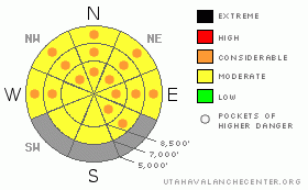
Danger by aspect and elevation on slopes approaching 35° or steeper.
(click HERE for tomorrow's danger rating)
|
Danger Rose Tutorial
|
Overall this morning, there is a MODERATE danger in the backcountry, and you could trigger dangerous wet avalanches on steep slopes with saturated snow in many areas. Despite windy conditions, the danger will rise, with pockets of CONSIDERABLE in many areas, especially in terrain sheltered from a south wind, with daytime and solar heating. Some large local cornices may naturally fail in the heat of the day, and you should stay off and out from under steep slopes with large cornices or soft saturated snow.
Evaluate the snow and terrain carefully and use good travel habits. |
|
|
CURRENT CONDITIONS |

|
Today's south wind will hopefully keep things from getting too hot, but It'll only speed-up the early melt-down. The un-seasonally warm weather will continue, only it'll be a little warmer today and still without a solid overnight freeze for nearly a week now.... I'd expect to find many slopes with slushy and structure less isothermal snow. At upper elevations and on slopes facing the northern half of the compass, the snow is still layered and dry under a gradually deepening saturated surface. You'll find slushy spring riding conditions if you can keep em cool, but you should avoid steep slopes with melt-softened slushy snow. By afternoon, I found the very wet surface snow quite sticky, and the suction on the skis worked the already warm engine far too hard. You'll find better, more solid snow and faster conditions early in the day.
Despite incoming clouds and increasing south winds overnight, mountain temperatures stayed well above freezing. The CSI weather station at 9700' on Logan Peak reports 38 degrees, with a 25 mph south wind and gusts to 50. Its a balmy 42 degrees at the 8400' Tony Grove Snotel, which is now reading 88% of normal water content for the date, with 73 inches of total snow on the ground. |
|
|
RECENT ACTIVITY |

|
Natural loose wet avalanches were reported from the backcountry on slopes at most elevations across the Wasatch Range yesterday. In the Ogden Area Mountains, a significant and fairly long-running natural wet avalanche occurred at around noon on northeast facing slope.
It's been a warm week in the Logan backcountry and we've also seen a fair amount of wet avalanche activity. This includes sizable natural loose wet avalanches and glide cracks opening up on steep slopes across the region......I've been able to post a few photos on our Website:
(3-18-09 Mendon Peak Area photos)
(3-19-09, Morning Glory photos)
(3-20-09 photos of Wilderness Peak glide cracks) |
|
|
THREAT #1 |

|
| WHERE |
PROBABILITY |
SIZE |
TREND |

|
|
|
|
| |
|
|
Over the next
12 hours.
|
|
|
Although windy conditions will provide much needed air conditioning today, we'll see the warmest day yet in a string of unseasonably warm days with poor overnight freezes. It stayed quite mild overnight in the mountains last night, and today's high temperatures will once again likely top 50 degrees at 9000'. Terrain sheltered from a south wind is likely to be more dangerous.
Avoid or move off of and away from steep slopes with soft and saturated snow today... |
|
|
THREAT #2 |

|
| WHERE |
PROBABILITY |
SIZE |
TREND |

|
|
|
|
| |
|
|
Over the next
24
hours.
|
|
|
Huge overhanging cornices could naturally collapse with today's warmth. Many may be near the breaking point, just waiting for you to send them careening over the edge. I don't think I'd be playing around on or under any of these monsters today.... |
|
|
MOUNTAIN WEATHER |

|
Rain and snow showers, and a thunder storm or two are possible later today and into tonight. Looks like a fairly significant storm will impact the region beginning around midnight tonight and lasting through Monday. Expect a few inches of accumulation and continued strong winds overnight...The National Weather Service predicts 5 to 9 inches of accumulation at 9000' in the Bear River Range tomorrow with southwest winds, and accumulating snow likely continuing through Sunday night. |
|
|
GENERAL ANNOUNCEMENTS |
The North American Avalanche Danger Scale is being revised for next winter. Our friends in Canada have created a short survey found at the following link. Please help ensure the new Avalanche Danger Scale is effective by completing a survey. (click HERE)
Our "Know before You Go" video is available online..... (click HERE to watch it)
Please let us know what you're seeing in the backcountry, especially if you see or trigger an avalanche, by leaving us a message at (435-)755-3638 or 1-800-662-4140. Or, you can always e-mail us at uac@utahavalanchecenter.org. . Your observations are very important for our program.....
This advisory is from the U.S.D.A. Forest Service, which is solely responsible for its content. This advisory describes general avalanche conditions and local variations always occur.
The Utah Avalanche Center depends on contributions from users like you to support our work.
I will update this advisory by around 7:30 Monday morning. |
|
|
This information does not apply to developed ski areas or highways where avalanche control is normally done. This advisory is from the U.S.D.A. Forest Service, which is solely responsible for its content. This advisory describes general avalanche conditions and local variations always occur. |
|
This advisory provided by the USDA Forest Service, in partnership with:
The Friends of the Utah Avalanche Center, Utah Division of State Parks and Recreation, Utah Division of Emergency Management, Salt Lake County, Salt Lake Unified Fire Authority and the friends of the La Sal Avalanche Center. See our Sponsors Page for a complete list. |
