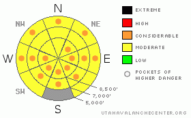
BOTTOM LINE
Danger by aspect and elevation on slopes approaching 35° or steeper.
(click HERE for tomorrow's danger rating)
|
Danger Rose Tutorial
|
Overall this morning, there is a MODERATE danger in the backcountry, and you could trigger dangerous wet avalanches on steep slopes with saturated snow in many areas. The danger will rise to CONSIDERABLE in some areas with daytime and solar heating. Some large local cornices may naturally fail in the heat of the day, and you should stay off and out from under steep slopes with large cornices or soft saturated snow.
Evaluate the snow and terrain carefully and use good travel habits. |
|
|
CURRENT CONDITIONS |

|
It's officially the first day of Spring, and the warm weather will continue, only it'll be a little warmer today and without a solid overnight freeze for nearly a week now.... I'd expect to find many slopes with slushy and structureless isothermal snow. At upper elevations, the snow on many slopes is still layered and dry under a gradually deepening saturated surface.
Despite some overnight clearing, mountain temperatures stayed well above freezing. The CSI weather station at 9700' on Logan Peak reports 35 degrees, and its a balmy 38 at the 8400' Tony Grove Snotel. You'll find slushy spring riding conditions if you can keep em cool, but you should avoid steep slopes with melt-softened slushy snow. |
|
|
RECENT ACTIVITY |
|
|
|
THREAT #1 |

|
| WHERE |
PROBABILITY |
SIZE |
TREND |

|
|
|
|
| |
|
|
Over the next
8 hours.
|
|
|
We'll see the warmest day yet in a string of unseasonably warm days with poor overnight freezes. It stayed quite mild overnight in the mountains last night, and today's high temperatures will likely top 50 degrees at 9000'.
Avoid steep slopes with soft saturated snow today... |
|
|
THREAT #2 |

|
| WHERE |
PROBABILITY |
SIZE |
TREND |

|
|
|
|
| |
|
|
Over the next
24
hours.
|
|
|
Huge overhanging cornices could naturally collapse with today's warmth. Many may be near the breaking point, just waiting for you to send them careening over the edge. I don't think I'd be playing around under any of these monsters today.... |
|
|
MOUNTAIN WEATHER |

|
Looks like the warm spell will continue, with party cloudy skies and increasing south winds today and tonight... It'll be mostly cloudy and warm again tomorrow, and quite windy. Rain and snow showers, and a thunder storm or two are possible today and tonight. Looks like a fairly significant storm will impact the region beginning Saturday night through Sunday and despite questions as to the locations of the heaviest snowfall, there is potential for good and substantial accumulations in our area.... |
|
|
GENERAL ANNOUNCEMENTS |
Please show your support for the Logan branch of the Utah Avalanche Center and help us create more helpful forecast products by taking our quick and easy on-line Web survey, (click HERE to partake).
The North American Avalanche Danger Scale is being revised for next winter. Our friends in Canada have created a short survey found at the following link. Please help ensure the new Avalanche Danger Scale is effective by completing a survey. (click HERE)
Our "Know before You Go" video is available online..... (click HERE to watch it)
Please let us know what you're seeing in the backcountry, especially if you see or trigger an avalanche, by leaving us a message at (435-)755-3638 or 1-800-662-4140. Or, you can always e-mail us at uac@utahavalanchecenter.org. . Your observations are very important for our program.....
This advisory is from the U.S.D.A. Forest Service, which is solely responsible for its content. This advisory describes general avalanche conditions and local variations always occur.
The Utah Avalanche Center depends on contributions from users like you to support our work.
I will update this advisory by around 7:30 Saturday morning. |
|
|
This information does not apply to developed ski areas or highways where avalanche control is normally done. This advisory is from the U.S.D.A. Forest Service, which is solely responsible for its content. This advisory describes general avalanche conditions and local variations always occur. |
|
This advisory provided by the USDA Forest Service, in partnership with:
The Friends of the Utah Avalanche Center, Utah Division of State Parks and Recreation, Utah Division of Emergency Management, Salt Lake County, Salt Lake Unified Fire Authority and the friends of the La Sal Avalanche Center. See our Sponsors Page for a complete list. |
