SPECIAL ANNOUNCEMENT |
 |
The North American Avalanche Danger Scale is being revised for next winter. Our friends in Canada have created a short survey found at the following link. Please help ensure the new Avalanche Danger Scale is effective by completing a survey. (click HERE) |
|
|
BOTTOM LINE
Danger by aspect and elevation on slopes approaching 35° or steeper.
(click HERE for tomorrow's danger rating)
|
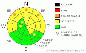
Danger Rose Tutorial
|
(3-17-09)
--Well, I did leave some green on the danger rose to celebrate the day. But, there is a MODERATE danger in the backcountry, and dangerous avalanche conditions exist on some upper elevation slopes exposed to wind drifting and on any slope steeper than about 35 degrees with saturated soft snow. Wet avalanches are most likely on normally shady slopes with saturated fine grained snow at mid and lower elevations....You could also trigger sizable cornice-falls along the high exposed ridge-lines.....
Evaluate the snow and terrain carefully and use good travel habits. |
|
|
CURRENT CONDITIONS |

|
You'll still be able to find areas with lingering settled powder conditions, mainly at upper elevations and on slopes that aren't overly exposed to sun or wind, but these stashes are rapidly becoming harder to find. The snow on many lower and mid elevation sunny slopes is somewhat supportable and almost corn-like. You can see areas where the yellowish dust, deposited at the beginning of the month, has melted its way back to the surface. Riding conditions are good, on mostly supportable snow, but don't expect to find many areas open to riding that aren't fairly heavily tracked up by the weekend crowds....
Overnight winds at the Campbell Scientific weather station on Logan Peak shifted from the southwest and are currently posting 20 to 25 mph average speeds.....The total snow stake at the Tony Grove Snotel reads 81 inches, with 93% of normal water content and its already a balmy 35 degrees at 8400'. |
|
|
RECENT ACTIVITY |

|
Not much significant avalanche activity reported from the backcountry since Monday's storm, which spawned widespread natural and a few human triggered avalanches.......(recent avalanche photos from 3-13-09)
We've observed a few natural loose wet avalanches off steep slopes with saturated surface snow in the past few days....(****new 3-16-09 photos) |
|
|
THREAT #1 |

|
| WHERE |
PROBABILITY |
SIZE |
TREND |
|
|
|
|
| |
|
|
Over the next
24
hours.
|
|
|
Triggered wind slab avalanches are possible on steep slopes in exposed terrain, especially on the lee side of prominent ridge-lines. Watch for wind slabs in terrain features like gullies or scoops, and stiffer wind deposited snow around cliff bands and sub-ridges in exposed terrain. Today's danger will be in the form of hard slab potential. They are not well managed, since they can sometimes let you get well out on them before breaking above you..... |
|
|
THREAT #2 |

|
| WHERE |
PROBABILITY |
SIZE |
TREND |
|
|
|
|
| |
|
|
Over the next
12 hours.
|
|
|
The danger will move into the trees and shady slopes where all the soft settled powder was hiding before yesterday's round of greenhousing. Wet avalanches are possible on any steep slope with saturated surface snow, and are most likely today on shady lower and mid elevation slopes. Roller balls or pin-wheels often foretell wet avalanche activity. Fresh natural avalanches on similar slopes are of-course, obvious red flags.... |
|
|
THREAT #3 |

|
| WHERE |
PROBABILITY |
SIZE |
TREND |
|
|
|
|
| |
|
|
Over the next
24
hours.
|
|
|
With warm and windy weather conditions, some of the giant local overhanging cornices are suspect again today, and you still might trigger dangerous cornice-falls along exposed ridge-lines. These are often quite deceptive, and might break farther back or wider than expected. |
|
|
MOUNTAIN WEATHER |

|
It should be warm, cloudy, and blustery in the mountains today, as a mild westerly zonal flow controls the weather pattern. There is a chance of a little snow at upper elevations in our area as weak disturbances race by to our north. This weather pattern will continue for the next couple days before a stronger high pressure system sets up over the region for the latter half of the week. Big changes are on the horizon, perhaps for next weekend, as the low pressure trough, now firmly stalled over the eastern Pacific, will move inland and should bring us a good chance for substantial spring storminess. |
|
|
GENERAL ANNOUNCEMENTS |
Please show your support for the Logan branch of the Utah Avalanche Center and help us create more helpful forecast products by taking our quick and easy on-line Web survey, (click HERE to partake).
Our "Know before You Go" video is available online..... (click HERE to watch it)
Please let us know what you're seeing in the backcountry, especially if you see or trigger an avalanche, by leaving us a message at (435-)755-3638 or 1-800-662-4140. Or, you can always e-mail us at uac@utahavalanchecenter.org. . Your observations are very important for our program.....
This advisory is from the U.S.D.A. Forest Service, which is solely responsible for its content. This advisory describes general avalanche conditions and local variations always occur.
The Utah Avalanche Center depends on contributions from users like you to support our work.
I will update this advisory by around 7:30 Wednesday morning. |
|
|
This information does not apply to developed ski areas or highways where avalanche control is normally done. This advisory is from the U.S.D.A. Forest Service, which is solely responsible for its content. This advisory describes general avalanche conditions and local variations always occur. |
|
This advisory provided by the USDA Forest Service, in partnership with:
The Friends of the Utah Avalanche Center, Utah Division of State Parks and Recreation, Utah Division of Emergency Management, Salt Lake County, Salt Lake Unified Fire Authority and the friends of the La Sal Avalanche Center. See our Sponsors Page for a complete list. |
