BOTTOM LINE
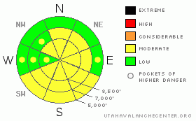
Danger by aspect and elevation on slopes approaching 35° or steeper.
(click HERE for tomorrow's danger rating)
|
Danger Rose Tutorial
|
There is a MODERATE danger, and dangerous avalanche conditions exist on some steep slopes in the region. You could trigger wind slab avalanches and/or cornice-falls in upper and mid-elevation terrain exposed to wind drifting. Solar warming will cause an increasing danger of wet avalanches on steep slopes with moist or saturated surface snow.
Evaluate the snow and terrain carefully and use good travel habits. |
|
|
CURRENT CONDITIONS |

|
Instabilities associated with Monday's storm are mostly healed by now, with lots of settlement within the copious new snow. You'll still be able to find nice settled powder conditions, especially on sheltered and shady slopes. Slopes exposed to yesterday's midday solar heating developed a thin sun-crust, and upper and mid-elevation slopes exposed to Tuesday's wind are either drifted-in or scoured-off or both.
It should be mostly sunny today and again tomorrow, with calm and gradually warming weather conditions in the mountains. |
|
|
RECENT ACTIVITY |

|
Monday's storm spawned hundreds of natural soft slab avalanches in the Logan region, with some potent powder avalanches running fast and far. We intentionally triggered numerous soft slab avalanches, and although avalanche conditions were quite active, the soft slabs consisting of new snow were quite easily triggered, and everything seemed manageable enough. Until, as we re-ascended for more, we came across a large fresh pile of debris from a long-running natural on our hour-and-a-half-old skin track. (3-9-09 photos)
Observers report that most steep slopes at all elevations and most aspects in the Wellsville Range also naturally avalanched during the storm. Snow safety teams at Powder Mountain report an active day Tuesday, with numerous triggered soft slab avalanches and lots of significant drifting. Settlement reportedly helped stabilize the new snow (at least in sheltered terrain) by Tuesday afternoon... |
|
|
THREAT #1 |

|
| WHERE |
PROBABILITY |
SIZE |
TREND |

|
|
|
|
| |
|
|
Over the next
24
hours.
|
|
|
Tuesday's west and southwest winds weren't all that strong, but Monday's copious snow was of the light and powdery variety. With all that easily transportable snow available, extensive drifting occurred in exposed terrain.
Wind slab avalanches are possible in exposed terrain at all elevations, but most likely up high. It is best to avoid steep areas with stiffer wind deposits especially on the lee side of prominent ridge-lines. Watch for and stay clear of fresh wind slabs in terrain features like gullies or scoops, and stiffer cross-loaded snow around cliff bands and sub-ridges in exposed terrain. |
|
|
THREAT #2 |

|
| WHERE |
PROBABILITY |
SIZE |
TREND |

|
|
|
|
| |
|
|
Over the next
24
hours.
|
|
|
The giant local overhanging cornices are likely suspects again today, and you could trigger dangerous cornice-falls along exposed ridge-lines. These are often quite deceptive, and are likely to break farther back or much wider than expected. Be sure your party stays well spread apart if traveling along a corniced ridge-line. |
|
|
THREAT #3 |

|
| WHERE |
PROBABILITY |
SIZE |
TREND |

|
|
|
|
| |
|
|
Over the next
10 hours.
|
|
|
Solar warming and calm conditions will cause an increasing danger of wet avalanches on steep sunny slopes with fresh snow that becomes moist or saturated with heating. With the large amount of new snow at lower and mid-elevations, especially in southern Cache Valley, we are set up for sizable loose wet avalanches. Triggered wet avalanches are possible on any steep slope with saturated surface snow. |
|
|
MOUNTAIN WEATHER |

|
A weak high pressure system will be over the region for the next couple days... Expect warming daytime temperatures, with Saturday quite mild with pre-frontal southwest winds pumping in warm moist air ahead of the next weak appearing Pacific storm, which will impact the region Saturday night and Sunday morning.
Looks like it'll get a lot warmer next week...... |
|
|
GENERAL ANNOUNCEMENTS |
Please show your support for the Logan branch of the Utah Avalanche Center and help us create more helpful forecast products by taking our quick and easy on-line Web survey, (click HERE to partake).
Our "Know before You Go" video is available online..... (click HERE to watch it)
Please let us know what you're seeing in the backcountry, especially if you see or trigger an avalanche, by leaving us a message at (435-)755-3638 or 1-800-662-4140. Or, you can always e-mail us at uac@utahavalanchecenter.org. . Your observations are very important for our program.....
This advisory is from the U.S.D.A. Forest Service, which is solely responsible for its content. This advisory describes general avalanche conditions and local variations always occur.
The Utah Avalanche Center depends on contributions from users like you to support our work.
I will update this advisory by around 7:30 Friday morning. |
|
|
This information does not apply to developed ski areas or highways where avalanche control is normally done. This advisory is from the U.S.D.A. Forest Service, which is solely responsible for its content. This advisory describes general avalanche conditions and local variations always occur. |
|
This advisory provided by the USDA Forest Service, in partnership with:
The Friends of the Utah Avalanche Center, Utah Division of State Parks and Recreation, Utah Division of Emergency Management, Salt Lake County, Salt Lake Unified Fire Authority and the friends of the La Sal Avalanche Center. See our Sponsors Page for a complete list. |
