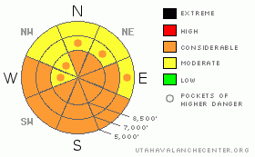
BOTTOM LINE
Danger by aspect and elevation on slopes approaching 35° or steeper.
(click HERE for tomorrow's danger rating)
|
Danger Rose Tutorial
|
There is a CONSIDERABLE danger, and dangerous avalanche conditions exist on many steep slopes in the region. You could trigger dangerous wind slab avalanches and/or large cornice-falls in upper and mid-elevation terrain exposed to extensive wind drifting. Avoid slopes steeper around 35 degrees with significant deposits of drifted snow. Solar warming will cause an increasing danger of significant and potentially dangerous wet avalanches on steep slopes with moist or saturated surface snow. Avoid and stay out from under steep sunny slopes and obvious or historic avalanche paths with warming or saturated fresh snow.
Use conservative decision making, careful route finding, and wise travel protocols. Training and experience are essential for safe backcountry travel today. |
|
|
CURRENT CONDITIONS |

|
The Central Bear River Range got a nice shot of snow on Monday, with Beaver Mountain yesterday morning reporting a 48 hr storm total of 19 inches... The Tony Grove Snotel reported 1.2 inches of water equivalent with a bit over a foot of new snow. The Southern Bear Rivers and the Wellsvilles got hammered even harder by the storm, with perhaps more snow at the valley floors. At the far south end of Cache Valley, the town of Paradise claims 30 inches of accumulation.
It should be mostly sunny today and again tomorrow, with calm and gradually warming weather conditions in the mountains. |
|
|
RECENT ACTIVITY |

|
Monday's storm spawned hundreds of natural soft slab avalanches in the Logan region, with some potent powder avalanches running fast and far. We intentionally triggered numerous soft slab avalanches on Monday, and although avalanche conditions were quite active, the soft slabs consisting of new snow were quite easily triggered, and everything seemed manageable enough. Until as we re-ascended for more, we came across a large fresh pile of debris from a long-running natural on our hour-and-a-half-old skin track. (3-9-09 photos)
Observers report that most steep slopes at all elevations and most aspects in the Wellsville Range also naturally avalanched during the storm. Snow safety teams at Powder Mountain report an active day yesterday, with numerous triggered soft slab avalanches and lots of significant drifting. Settlement reportedly helped stabalize the new snow (at least in sheltered terrain) by yesterday afternoon... |
|
|
THREAT #1 |

|
| WHERE |
PROBABILITY |
SIZE |
TREND |
|
|
|
|
| |
|
|
Over the next
24
hours.
|
|
|
Yesterday's west and southwest winds weren't all that strong, but Monday's copious snow was of the light and powdery variety. With all that easily transportable snow available, extensive drifting occurred in exposed terrain as westerly winds peaked yesterday afternoon. ( Moderately strong west winds at the CSI weather station on Logan Peak, with 25 mph hourly averages posted for a couple hours in the afternoon.)
Wind slab avalanches are possible in exposed terrain at all elevations. In fact, you probably would trigger dangerous wind slab avalanches, if you were to venture onto steep slopes with significant deposits of recently drifted snow today. It is best to avoid steep areas with stiffer wind deposits especially on the lee side of prominent ridge-lines. Watch for and stay clear of fresh wind slabs in terrain features like gullies or scoops, and stiffer cross-loaded snow around cliff bands and sub-ridges in exposed terrain. |
|
|
THREAT #2 |

|
| WHERE |
PROBABILITY |
SIZE |
TREND |
|
|
|
|
| |
|
|
Over the next
24
hours.
|
|
|
On another wind-related note, huge and "un-manageable" triggered cornice-falls were reported from yesterday in the Wasatch Range.
The giant local overhanging cornices are likely suspects today, and you could trigger large and dangerous cornice-falls along exposed ridge-lines. These are often quite deceptive, and are likely to break farther back or much wider than expected. Be sure your party stays well spread apart if traveling along a corniced ridge-line. |
|
|
THREAT #3 |

|
| WHERE |
PROBABILITY |
SIZE |
TREND |
|
|
|
|
| |
|
|
Over the next
10 hours.
|
|
|
Solar warming and calm conditions will cause an increasing danger of wet avalanches on steep sunny slopes with fresh snow that becomes moist or saturated with heating. With the large amount of new snow at lower and mid-elevations, especially in southern Cache Valley, we are set up for sizable loose wet avalanches. Triggered wet avalanches are likely on any steep slope with saturated surface snow and some large naturals are also possible. You should avoid and stay out from under steep warming slopes and obvious or historic avalanche paths exposed to sustained periods of direct sun. |
|
|
MOUNTAIN WEATHER |

|
A weak high pressure system will set up over the region for the next couple days... The next Pacific storm will impact the region late in the coming Weekend. |
|
|
GENERAL ANNOUNCEMENTS |
Please show your support for the Logan branch of the Utah Avalanche Center and help us create more helpful forecast products by taking our quick and easy on-line Web survey, (click HERE to partake).
Our "Know before You Go" video is available online..... (click HERE to watch it)
Please let us know what you're seeing in the backcountry, especially if you see or trigger an avalanche, by leaving us a message at (435-)755-3638 or 1-800-662-4140. Or, you can always e-mail us at uac@utahavalanchecenter.org. . Your observations are very important for our program.....
This advisory is from the U.S.D.A. Forest Service, which is solely responsible for its content. This advisory describes general avalanche conditions and local variations always occur.
The Utah Avalanche Center depends on contributions from users like you to support our work.
I will update this advisory by around 7:30 Friday morning. |
|
|
This information does not apply to developed ski areas or highways where avalanche control is normally done. This advisory is from the U.S.D.A. Forest Service, which is solely responsible for its content. This advisory describes general avalanche conditions and local variations always occur. |
|
This advisory provided by the USDA Forest Service, in partnership with:
The Friends of the Utah Avalanche Center, Utah Division of State Parks and Recreation, Utah Division of Emergency Management, Salt Lake County, Salt Lake Unified Fire Authority and the friends of the La Sal Avalanche Center. See our Sponsors Page for a complete list. |
