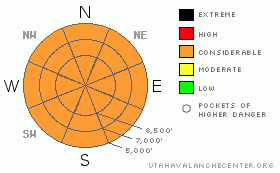
BOTTOM LINE
Danger by aspect and elevation on slopes approaching 35° or steeper.
(click HERE for tomorrow's danger rating)
|
Danger Rose Tutorial
|
Heavy snowfall and rapid accumulations will probably cause the avalanche danger to rise to CONSIDERABLE today, and you will likely find dangerous avalanche conditions on numerous slopes steeper than around 35 degrees, especially during periods of heavy precipitation. A round of natural avalanches is possible, especially when precipitation rates peak with frontal passage around midday, or with any significant increase in wind and subsequent drifting. Avoid and stay out from under steep slopes and obvious or historic avalanche paths.
Use conservative decision making, careful route finding, and wise travel protocols. Training and experience are essential for safe backcountry travel today. |
|
|
CURRENT CONDITIONS |

|
We'll need to do a bit of shoveling just to get out of the house this morning, as Cache Valley is getting a good shot of snow.....Mountain remote sensors and Snotel sites report similar amounts, with 8 inches reported as of 5:00 am at USU Doc Daniels, Bug Lake, and Beaver Mountain.
The Tony Grove Snotel is lagging a bit, with 5 and a half inches containing 3/10ths of water. There is currently 87 inches of total snow containing 95% of normal water for the date. Its 9 degrees at the Campbell Scientific Logan Peak weather station at 9700'. A moderate west wind pushed 20 mph hourly averages overnight, but it diminished in the past couple hours and is now only showing 5-10 mph. |
|
|
RECENT ACTIVITY |

|
Observers report a few natural newer snow wind slab avalanches, running on the prominent dusty layer from last week, mostly on east and northeast facing slopes. Over the weekend, a large cornice-fall cleaned out the moist snow in the long path below it in North Hell's Canyon, leaving a broad yellowish streak as the dust-plagued bed surface. In fact, numerous natural wet avalanches from solar warming, also leaving yellowish streaks, were reported in the past couple days. |
|
|
THREAT #1 |

|
| WHERE |
PROBABILITY |
SIZE |
TREND |

|
|
|
|
| |
|
|
Over the next
24
hours.
|
|
|
Heavy snowfall and rapid accumulations will cause the danger of new snow avalanches to rise significantly on steep slopes during the day today. A round of natural, potentially fast moving, powder avalanches is possible, especially when precipitation rates peak with frontal passage around midday, or with any significant increase in wind and subsequent drifting.
Sizable triggered and natural dry loose avalanches or sluffs are likely on any steep slope today. These are generally manageable unless terrain traps like trees, gullies, or cliffs are involved. |
|
|
THREAT #2 |

|
| WHERE |
PROBABILITY |
SIZE |
TREND |

|
|
|
|
| |
|
|
Over the next
24
hours.
|
|
|
Avalanches may step down to or just below the warm, yellowish dusty layer that was on the surface early last week. It is not uncommon for this kind of solid and slippery layer to act as a bed surface for widespread avalanches. Also, a couple separate observers noted a clean shear on small faceted grains developing just below the dusty layer. (3-7-09 snow profile) |
|
|
MOUNTAIN WEATHER |

|
The National Weather Service in Salt Lake City continued and increased the coverage of a WINTER STORM WARNING for all the mountains in Utah through Tuesday evening.......
The National Weather Service forecasts another 10-20 inches of accumulation in the Bear River Range before the storm moves out of our region late Tuesday. Winds should shift around from the northwest and increase a little today with frontal passage. Expect another slight increase in strength and a shift from the west tomorrow.
A weak high presure system will set up over the region mid-week, and there's a chance for a bit more snow towards the end of the work week. |
|
|
GENERAL ANNOUNCEMENTS |
Please show your support for the Logan branch of the Utah Avalanche Center and help us create more helpful forecast products by taking our quick and easy on-line Web survey, (click HERE to partake).
Our "Know before You Go" video is available online..... (click HERE to watch it)
Please let us know what you're seeing in the backcountry, especially if you see or trigger an avalanche, by leaving us a message at (435-)755-3638 or 1-800-662-4140. Or, you can always e-mail us at uac@utahavalanchecenter.org. . Your observations are very important for our program.....
This advisory is from the U.S.D.A. Forest Service, which is solely responsible for its content. This advisory describes general avalanche conditions and local variations always occur.
The Utah Avalanche Center depends on contributions from users like you to support our work.
I will update this advisory by around 7:30 Wednesday morning. |
|
|
This information does not apply to developed ski areas or highways where avalanche control is normally done. This advisory is from the U.S.D.A. Forest Service, which is solely responsible for its content. This advisory describes general avalanche conditions and local variations always occur. |
|
This advisory provided by the USDA Forest Service, in partnership with:
The Friends of the Utah Avalanche Center, Utah Division of State Parks and Recreation, Utah Division of Emergency Management, Salt Lake County, Salt Lake Unified Fire Authority and the friends of the La Sal Avalanche Center. See our Sponsors Page for a complete list. |
