BOTTOM LINE
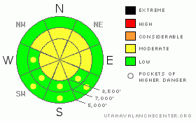
Danger by aspect and elevation on slopes approaching 35° or steeper.
(click HERE for tomorrow's danger rating)
|
Danger Rose Tutorial
|
There is a MODERATE danger in the backcountry, and you could trigger wind slab avalanches consisting of freshly drifted snow on exposed lee slopes steeper than around 35 degrees, especially along exposed ridge-lines. You'll find a LOW danger on most other slopes in the region, especially at lower elevations, in lower angled terrain, and in sheltered shady areas. Evaluate the snow and terrain carefully and continue to use good travel habits... |
|
|
CURRENT CONDITIONS |

|
Yesterday we found great dry powder conditions, with lots more new snow at upper elevations, especially in the high meadows and basins. I had to stand up on the rails for a few miles just to see over the wave of powder billowing over my windshield. Cloud cover until late in the day kept the powder fairly nice on slopes facing all directions. Needless to say, riding and turning conditions improved significantly in the backcountry in the past couple days. At mid and lower elevations, you can still feel the moist and now frozen solid dusty underlying snow from last week.
The Tony Grove Snotel reported about 5 inches yesterday with 3/10s of an inch of water, and the station is reporting 89 inches of total snow containing 96% of normal water for the date. Its 6 degrees at the CSI weather station at 9700' on Logan Peak, with a 5 mph east-northeast wind. |
|
|
RECENT ACTIVITY |

|
An observer on Tuesday noticed a significant natural wet/ persistent slab avalanche near Emigration Summit on a somewhat lower angled northeast facing slope at around 8400' in elevation. (3-3-09 photos)
We triggered a few small soft slabs near the ridge-tops yesterday. These were only a few inches deep and 20-30' wide. Also, sledders report extensive loose dry sluffs and manageable triggered new snow avalanches on steep slopes in the Tony Grove Area ... |
|
|
THREAT #1 |

|
| WHERE |
PROBABILITY |
SIZE |
TREND |

|
|
|
|
| |
|
|
Over the next
24
hours.
|
|
|
In some cases, Thursday's new snow didn't stick so well to the moist and now solid dusty snow that was on the surface during last week's exceptionally warm spell.
(3-8-09)- Southwest winds increased on Saturday night and will continue to pick up ahead of the incoming storm. Today you might trigger wind slab avalanches consisting of fresh drifted snow on steep slopes, especially along exposed ridge-lines. Also watch for stiffer, drifted snow around and in terrain features like gullies, cliff-bands, and sub-ridges.
Dry loose snow avalanches are possible on steep slopes with fresh powder. These are easily managed in most cases, but you don't want to find yourself stuck in a steep sided gully or hanging off some cliff-edge while a wave of loose snow is coming your way. |
|
|
THREAT #2 |

|
| WHERE |
PROBABILITY |
SIZE |
TREND |

|
|
|
|
| |
|
|
Over the next
8 hours.
|
|
|
Although it's not supposed to get very warm, solar heating can be quite intense this time of year. When the fresh powder is initially warmed by the sun, the surface snow will quickly become moist and prone to avalanching. Wet point-release type avalanches are easily managed in most cases, but you don't want to find yourself below one. |
|
|
THREAT #3 |

|
| WHERE |
PROBABILITY |
SIZE |
TREND |

|
|
|
|
| |
|
|
Over the next
24
hours.
|
|
|
There is potential for isolated avalanches to step down to a surface hoar layer buried intact back at the beginning of February. Surface hoar is a notoriously long lasting buried weak layer...Avalanches in the two to three foot deep range are rather unlikely but still possible today on isolated steep sheltered slopes where this layer persists.... |
|
|
MOUNTAIN WEATHER |

|
The next Pacific storm will impact the region late Sunday into Monday. This one has potential to produce significant snowfall across the region. Expect increasing and potentially strong southwest winds ahead of this storm to impact the mountians tomorrow and tomorrow evening.
(3-8-09) The National Weather Service in Salt Lake City has issued a WINTER STORM WARNING for the mountains in our area beginning at 6:00 Sunday Evening....... |
|
|
GENERAL ANNOUNCEMENTS |
Please show your support for the Logan branch of the Utah Avalanche Center and help us create more helpful forecast products by taking our quick and easy on-line Web survey, (click HERE to partake).
Our "Know before You Go" video is available online..... (click HERE to watch it)
The UAC depends on contributions from users like you to support our work. To find out more about how you can support our efforts to continue providing the avalanche forecasting and education that you expect please visit our Friends page.
Please let us know what you're seeing in the backcountry, especially if you see or trigger an avalanche, by leaving us a message at (435-)755-3638 or 1-800-662-4140. Or, you can always e-mail us at uac@utahavalanchecenter.org. . Your observations are very important for our program.....
This advisory is from the U.S.D.A. Forest Service, which is solely responsible for its content. This advisory describes general avalanche conditions and local variations always occur.
I will update this advisory by around 7:30 Monday morning. |
|
|
This information does not apply to developed ski areas or highways where avalanche control is normally done. This advisory is from the U.S.D.A. Forest Service, which is solely responsible for its content. This advisory describes general avalanche conditions and local variations always occur. |
|
This advisory provided by the USDA Forest Service, in partnership with:
The Friends of the Utah Avalanche Center, Utah Division of State Parks and Recreation, Utah Division of Emergency Management, Salt Lake County, Salt Lake Unified Fire Authority and the friends of the La Sal Avalanche Center. See our Sponsors Page for a complete list. |
