BOTTOM LINE
Danger by aspect and elevation on slopes approaching 35° or steeper.
(click HERE for tomorrow's danger rating)
|
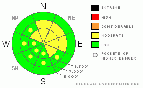
Danger Rose Tutorial
|
There is a MODERATE danger in the backcountry, and dangerous avalanche conditions exist in some areas, especially along exposed ridge-lines. You could trigger wind slab avalanches consisting of freshly drifted snow on some slopes steeper than around 35 degrees at upper and mid elevations, mainly in lee slope deposition areas. Triggered loose dry sluffs are likely on steep slopes with significant deposits of new snow, but are mostly manageable unless terrain features like trees, gullies, or cliffs become involved. Triggered persistent slab avalanches in the two to three foot deep range are unlikely but possible on a few isolated slopes where a buried weak layer persists.... You'll find a LOW danger on most slopes at lower elevations and in sheltered terrain.
Evaluate the snow and terrain carefully and use good travel habits... |
|
|
CURRENT CONDITIONS |

|
You can find good dry powder conditions, with substantially more new snow at upper elevations. In most cases you can still feel the moist and dusty underlying snow, which is gradually solidifying with the welcome colder temperatures. Riding and turning conditions improved significantly with yesterday's new snow, and we'll get a few more inches of accumulation today...
Looked like more snow up north yesterday, with Franklin Basin Snotel showing 10 inches and Beaver Mountain 7. The Tony Grove Snotel reported about 6 inches yesterday with 4/10s of an inch of water, and the station is reporting 84 inches of total snow containing 95% of normal water for the date.Its 9 degrees at the CSI weather station at 9700' on Logan Peak, with a 15 mph west wind. |
|
|
RECENT ACTIVITY |

|
An observer on Tuesday noticed a significant natural wet/ persistent slab avalanche near Emigration Summit on a somewhat lower angled northeast facing slope at around 8400' in elevation. (3-3-09 photos)
We triggered a few small soft slabs near the ridge-top yesterday by knocking off small cornice chunks. Also, loose dry sluffs followed us harmlessly down steep slopes... |
|
|
THREAT #1 |

|
| WHERE |
PROBABILITY |
SIZE |
TREND |

|
|
|
|
| |
|
|
Over the next
24
hours.
|
|
|
You might trigger wind slab avalanches consisting of fresh drifted snow on steep slopes, especially along exposed ridge-lines. Also watch for stiffer, drifted snow around and in terrain features like gullies, cliff-bands, and sub-ridges. New wind slabs will form today in some areas, with accumulating snow and moderate westerly winds forecast. |
|
|
THREAT #2 |

|
| WHERE |
PROBABILITY |
SIZE |
TREND |
|
|
|
|
| |
|
|
Over the next
24
hours.
|
|
|
Dry loose snow avalanches are possible on steep slopes with fresh powder. These are easily managed in most cases, but you don't want to find yourself stuck in a steep sided gully or hanging off some cliff-edge while a wave of loose snow is coming your way. |
|
|
THREAT #3 |

|
| WHERE |
PROBABILITY |
SIZE |
TREND |
|
|
|
|
| |
|
|
Over the next
24
hours.
|
|
|
The cold weather will help to keep this dragon at bay today, but you can still find a clean and sometimes energetic shear in some areas on the surface hoar layer buried intact back at the beginning of February.
Although it occurred under exceptionally warm temperatures, this week's natural avalanche near Emigration Summit (3-3-09 photos) illustrates the potential for avalanches to step down into this notoriously long lasting buried weak layer...Avalanches in the two to three foot deep range are rather unlikely but still possible today on steep sheltered slopes where this layer persists....
In some rare cases, a smaller wind slab or new snow avalanche overrunning such a slope could trigger a deeper, much more dangerous avalanche... |
|
|
MOUNTAIN WEATHER |

|
A weakening storm from Western Canada will bring some snow to our region, mainly this afternoon. Looks like most of the energy with this one will go to our south, and the mountains in Central Utah might get the better accumulations, but we are likely to pick up a couple inches anyway. The next storm will impact the region late Sunday into Monday, but it doesn't look too impressive either. |
|
|
GENERAL ANNOUNCEMENTS |
Please show your support for the Logan branch of the Utah Avalanche Center and help us create more helpful forecast products by taking our quick and easy on-line Web survey, (click HERE to partake).
Our "Know before You Go" video is available online..... (click HERE to watch it)
The UAC depends on contributions from users like you to support our work. To find out more about how you can support our efforts to continue providing the avalanche forecasting and education that you expect please visit our Friends page.
Please let us know what you're seeing in the backcountry, especially if you see or trigger an avalanche, by leaving us a message at (435-)755-3638 or 1-800-662-4140. Or, you can always e-mail us at uac@utahavalanchecenter.org. . Your observations are very important for our program.....
This advisory is from the U.S.D.A. Forest Service, which is solely responsible for its content. This advisory describes general avalanche conditions and local variations always occur.
I will update this advisory by around 7:30 Saturday morning. |
|
|
This information does not apply to developed ski areas or highways where avalanche control is normally done. This advisory is from the U.S.D.A. Forest Service, which is solely responsible for its content. This advisory describes general avalanche conditions and local variations always occur. |
|
This advisory provided by the USDA Forest Service, in partnership with:
The Friends of the Utah Avalanche Center, Utah Division of State Parks and Recreation, Utah Division of Emergency Management, Salt Lake County, Salt Lake Unified Fire Authority and the friends of the La Sal Avalanche Center. See our Sponsors Page for a complete list. |
