BOTTOM LINE
Danger by aspect and elevation on slopes approaching 35° or steeper.
(click HERE for tomorrow's danger rating)
|
Danger Rose Tutorial
|
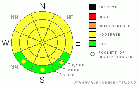
There is a MODERATE danger in the backcountry, and dangerous avalanche conditions exist on some terrain features. Exceptionally warm mountain temperatures in the past few days caused a danger of wet avalanches on steep slopes with saturated snow, but cooling today will help to diminish the threat. Dangerous triggered wet/persistent slab avalanches are still possible on isolated slopes steeper than about 30 degrees in areas where buried weak layers persist....There are slopes in exposed terrain where you could trigger stiff wind slab avalanches today, and fresh soft wind slabs consisting of new snow are likely to develop overnight with accumulating snow and wind in the forecast.
Evaluate the snow and terrain carefully and continue to practice good travel habits. |
|
|
CURRENT CONDITIONS |

|
Looks like another warm and windy morning in the backcountry, but the arrival of a cold front today will bring much needed cooling, and snowfall should commence in the mountains by evening. At 6:00 this morning, temperatures have dropped to 26 degrees at the CSI Logan Peak weather station at 9700', with a 30 mph southwest wind and gusts in the 50s. The Tony Grove Snotel at 8400' reports 34 degrees with 78 inches of total snow on the ground, containing 96% of normal water equivalent for the date. |
|
|
RECENT ACTIVITY |

|
Lots of roller balls and loose wet avalanches occurred across the region in the past few exceptionally warm days. Wet activity appeared especially prevalent in mid elevation sheltered terrain.
Everything was fine on Monday as we descended a treed slope in Mill Hollow, and we triggered a few small roller-balls, kind of fun to ski through as they harmlessly rolled through the trees. Until, my attentive partner yelled loudly, "Traverse left now!" which saved me from a giant, truck-sized roller-ball crashing through the trees in the fall-line right behind me.
An observer on Tuesday noticed a significant natural wet/persisent slab avalanche near Emigration Summit on a somewhat lower angled northeast facing slope at around 8400' in elevation. (3-3-09 photos) |
|
|
THREAT #1 |

|
| WHERE |
PROBABILITY |
SIZE |
TREND |

|
|
|
|
| |
|
|
Over the next
12 hours.
|
|
|
Cooler temperatures arriving with today's storm should help to diminish the danger that still exists on some steep slopes with saturated snow. |
|
|
THREAT #2 |

|
| WHERE |
PROBABILITY |
SIZE |
TREND |

|
|
|
|
| |
|
|
Over the next
24
hours.
|
|
|
You can still find a clean and sometimes energetic shear on the surface hoar layer buried intact back at the beginning of February. Also, our last slab avalanche cycle (2/17-2/20,) revealed the existence of a persistent weak layer consisting of surface hoar and/or small facets associated with a sun-crust on slopes facing the southern 3/8ths of the compass.
Triggered slab avalanches in the two to three foot deep range are possible on a few isolated, mainly mid elevation slopes where these layers persist.... |
|
|
THREAT #3 |

|
| WHERE |
PROBABILITY |
SIZE |
TREND |

|
|
|
|
| |
|
|
Over the next
12 hours.
|
|
|
You might trigger wind slab avalanches on steep drifted slopes, especially around and in terrain features like gullies, cliff-bands, and sub-ridges where some now very stiff slabs formed under the windy conditions in the past few days.... Fresh snowfall and winds overnight tonight will likely build new soft wind slabs.
Warmed up cornices can be super deceitful this time of year, sometimes breaking much further back than expected.... |
|
|
MOUNTAIN WEATHER |

|
Mountain temperatures may already be dropping this morning, but are expected to reach a high of 40 degrees at 9000' first. Expect continued strong southwest wind today and snow developing from the west late this afternoon. Fairly heavy snowfall is expected, but the front will speed quickly by and to the southeast, leaving only lingering showers overnight. The National Weather Service estimates 3 to 7 inches of accumulation in the Central Bear River Range.
Another, perhaps more productive storm is expected to impact the region late Friday and a progressive, moist and unsettled weather pattern will continue into the extended time-frame. |
|
|
GENERAL ANNOUNCEMENTS |
Please show your support for the Logan branch of the Utah Avalanche Center and help us create more helpful forecast products by taking our quick and easy on-line Web survey, (click HERE to partake).
Our "Know before You Go" video is available online..... (click HERE to watch it)
The UAC depends on contributions from users like you to support our work. To find out more about how you can support our efforts to continue providing the avalanche forecasting and education that you expect please visit our Friends page.
Please let us know what you're seeing in the backcountry, especially if you see or trigger an avalanche, by leaving us a message at (435-)755-3638 or 1-800-662-4140. Or, you can always e-mail us at uac@utahavalanchecenter.org. . Your observations are very important for our program.....
This advisory is from the U.S.D.A. Forest Service, which is solely responsible for its content. This advisory describes general avalanche conditions and local variations always occur.
I will update this advisory by around 7:30 Friday morning. |
|
|
This information does not apply to developed ski areas or highways where avalanche control is normally done. This advisory is from the U.S.D.A. Forest Service, which is solely responsible for its content. This advisory describes general avalanche conditions and local variations always occur. |
|
This advisory provided by the USDA Forest Service, in partnership with:
The Friends of the Utah Avalanche Center, Utah Division of State Parks and Recreation, Utah Division of Emergency Management, Salt Lake County, Salt Lake Unified Fire Authority and the friends of the La Sal Avalanche Center. See our Sponsors Page for a complete list. |
