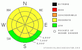
BOTTOM LINE
Danger by aspect and elevation on slopes approaching 35° or steeper.
(click HERE for tomorrow's danger rating)
|
Danger Rose Tutorial
|
There is a MODERATE danger in the backcountry, and dangerous avalanche conditions exist or are developing on some terrain features. Continued exceptionally warm mountain temperatures will cause a danger of wet avalanches on steep slopes with saturated snow at all elevations. Dangerous, triggered wet/persistent slab avalanches are possible on some very steep slopes in areas where buried weak layers persist....Heating today may cause some large, overhanging, and often deceitful ridge-top cornices to topple unto slopes below and others to become unstable and sensitive to your weight. There may also be a few isolated very steep slopes in exposed terrain where you could trigger stiff wind slab avalanches.
Evaluate the snow and terrain carefully and continue to practice good travel habits. |
|
|
CURRENT CONDITIONS |

|
Looks like another very warm and windy day in the backcountry. It'll be hard to find any dry snow today, even at the highest elevations. As the fresh snow from last week melts, it appears darker than the underlying snow. It's yellowish from dust picked up in the desert by strong south winds. Unfortunately, this will speed up the melting of this spring's snowpack.
At 6:00 this morning, its already 35 degrees at the CSI Logan Peak weather station at 9700', with a 35 mph southwest wind. The Tony Grove Snotel at 8400' reports 83 inches of total snow on the ground, containing 97% of normal water equivalent for the date. |
|
|
RECENT ACTIVITY |

|
No avalanches reported from a very busy local backcountry over the weekend......
I noticed a few shallow wet avalanches Saturday on southwest facing slopes in the Mt. Naomi Wilderness... |
|
|
THREAT #1 |

|
| WHERE |
PROBABILITY |
SIZE |
TREND |

|
|
|
|
| |
|
|
Over the next
12 hours.
|
|
|
Very warm temperatures will create an increasing likelihood of wet avalanches on steep slopes at all elevations with saturated snow. I'm most concerned about the potential for deeper wet avalanches, mainly on sheltered mid-elevation slopes.
The warmth is also increasing the possiblity of wet/persitent slabs on some slopes plagued by buried weak layers. |
|
|
THREAT #2 |

|
| WHERE |
PROBABILITY |
SIZE |
TREND |

|
|
|
|
| |
|
|
Over the next
24
hours.
|
|
|
You can still find a clean and sometimes energetic shear on the surface hoar layer buried intact back at the beginning of February. Triggered slab avalanches in the two to three foot deep range are rather unlikely, but still possible on a few isolated and mostly shady mid elevation slopes where this layer persists....
Also, our last slab avalanche cycle (2/17-2/20,) revealed the existance of a persitent weak layer consisting of surface hoar and/or small facets associated with a sun-crust on slopes facing the southern 3/8ths of the compass. |
|
|
THREAT #3 |

|
| WHERE |
PROBABILITY |
SIZE |
TREND |

|
|
|
|
| |
|
|
Over the next
12 hours.
|
|
|
The warm temperatures at high elevations will cause our large ridge-top cornices to buckle and droop. Some will likely fail, while others will be thrown off balance and perhaps become sensitive to your weight. Cornices can be super deceitful this time of year, sometimes breaking much further back than expected....
You could trigger wind slab avalanches on some very steep drifted slopes, especially around and in terrain features like gullies, cliff-bands, and sub-ridges where some stiff slabs formed and continue forming today.... |
|
|
MOUNTAIN WEATHER |

|
Expect another very warm, windy, and cloudy day in the mountains today, with midday 9000' temperatures approaching 50 degrees! Rain showers are possible today to the tops of the highest peaks in the Bear River Range, up to around 9500', and drop only a little tonight and tomorrow, staying above 8000'. A cold front will bring colder temperatures and some snow to the mountains late Wednesday into Thursday. |
|
|
GENERAL ANNOUNCEMENTS |
Our "Know before You Go" video is available online..... (click HERE to watch it)
The UAC depends on contributions from users like you to support our work. To find out more about how you can support our efforts to continue providing the avalanche forecasting and education that you expect please visit our Friends page.
Please let us know what you're seeing in the backcountry, especially if you see or trigger an avalanche, by leaving us a message at (435-)755-3638 or 1-800-662-4140. Or, you can always e-mail us at uac@utahavalanchecenter.org. . Your observations are very important for our program.....
This advisory is from the U.S.D.A. Forest Service, which is solely responsible for its content. This advisory describes general avalanche conditions and local variations always occur.
I will update this advisory by around 7:30 Wednesday morning. |
|
|
This information does not apply to developed ski areas or highways where avalanche control is normally done. This advisory is from the U.S.D.A. Forest Service, which is solely responsible for its content. This advisory describes general avalanche conditions and local variations always occur. |
|
This advisory provided by the USDA Forest Service, in partnership with:
The Friends of the Utah Avalanche Center, Utah Division of State Parks and Recreation, Utah Division of Emergency Management, Salt Lake County, Salt Lake Unified Fire Authority and the friends of the La Sal Avalanche Center. See our Sponsors Page for a complete list. |
