BOTTOM LINE
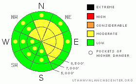
Danger by aspect and elevation on slopes approaching 35° or steeper.
(click HERE for tomorrow's danger rating)
|
Danger Rose Tutorial
|
There is a MODERATE danger in the backcountry, and although you'll find generally safe avalanche conditions in many areas, dangerous avalanche conditions exist or will develop on some terrain features. There are some steep slopes in exposed upper and mid elevation terrain where you could trigger stiff wind slab avalanches. Warm mountain temperatures and potential greenhouse heating will cause an increasing danger of loose wet avalanches on steep slopes with saturated surface snow. Dangerous persistent or deep hard slab avalanches are possible on a few very steep slopes in some isolated areas where a buried weak layer persists....
Continue to practice good travel habits and carefully evaluate the snow and terrain as you go. |
|
|
CURRENT CONDITIONS |

|
Looks like a very warm and windy day in the backcountry, and overnight mountain temperatures increased like a mid-nineties tech. stock portfolio. Expect temperatures and windspeeds to rise into the mid to upper 40s at 9000', and mostly cloudy conditions today.
At 6:00 this morning, its already 31 degrees at the CSI Logan Peak weather station at 9700', with a 28 mph southwest wind. The Tony Grove Snotel at 8400' reports 86 inches of total snow on the ground, containing 98% of normal water equivalent for the date. |
|
|
RECENT ACTIVITY |

|
No avalanches reported from a very busy local backcountry yesterday......
I noticed a few shallow wet avalanches on southwest facing slopes in the Mt. Naomi Wilderness... |
|
|
THREAT #1 |

|
| WHERE |
PROBABILITY |
SIZE |
TREND |

|
|
|
|
| |
|
|
Over the next
24
hours.
|
|
|
Increasing strong southwest winds, shifting from the northwest later today, will build stiff drifts and wind slabs in terrain dictated deposition areas. You could trigger wind slab avalanches on some very steep drifted slopes, especially around and in terrain features like gullies, cliff-bands, and sub-ridges where stiff slabs are forming today....
Corniced ridge-lines at upper elevations are obvious areas to watch for these developing wind slabs, but drifting is also likely to occur at mid and lower elevations in exposed terrain and in areas with significant transportable (or soft) snow on the surface. |
|
|
THREAT #2 |

|
| WHERE |
PROBABILITY |
SIZE |
TREND |

|
|
|
|
| |
|
|
Over the next
8 hours.
|
|
|
Very warm temperatures and additional greenhouse solar heating will create an increasing likelihood of loose wet avalanches on steep slopes with saturated surface snow. I'm most concerned about the potential on sheltered mid-elevation slopes with a good amount of fresh snow from late last week..... |
|
|
THREAT #3 |

|
| WHERE |
PROBABILITY |
SIZE |
TREND |

|
|
|
|
| |
|
|
Over the next
24
hours.
|
|
|
You can still find a clean and sometimes energetic shear on the surface hoar layer buried intact back at the beginnning of Feburary. Triggered slab avalanches in the two to three foot deep range are rather unlikely, but still possible on a few isolated and mostly shady mid elevation slopes where this layer persists.... |
|
|
MOUNTAIN WEATHER |

|
Expect a very warm and windy and cloudy day in the mountains today, with midday 9000' temperatures approaching 46 degrees. Southwest winds this morning will increase a bit and shift around from the northwest. We've got a chance for some snowfall tonight and the wind will shift back from the south. Cloud cover and warm winds will keep overnight temperatures fairly warm. Monday will also be windy and warm, with rain up to around 9000' in elevation on Monday night.
A better defined storm is possible mid-week with cooler temperatures likely. |
|
|
GENERAL ANNOUNCEMENTS |
Our "Know before You Go" video is available online..... (click HERE to watch it)
The UAC depends on contributions from users like you to support our work. To find out more about how you can support our efforts to continue providing the avalanche forecasting and education that you expect please visit our Friends page.
Please let us know what you're seeing in the backcountry, especially if you see or trigger an avalanche, by leaving us a message at (435-)755-3638 or 1-800-662-4140. Or, you can always e-mail us at uac@utahavalanchecenter.org. . Your observations are very important for our program.....
This advisory is from the U.S.D.A. Forest Service, which is solely responsible for its content. This advisory describes general avalanche conditions and local variations always occur.
I will update this advisory by around 7:30 Monday morning. |
|
|
This information does not apply to developed ski areas or highways where avalanche control is normally done. This advisory is from the U.S.D.A. Forest Service, which is solely responsible for its content. This advisory describes general avalanche conditions and local variations always occur. |
|
This advisory provided by the USDA Forest Service, in partnership with:
The Friends of the Utah Avalanche Center, Utah Division of State Parks and Recreation, Utah Division of Emergency Management, Salt Lake County, Salt Lake Unified Fire Authority and the friends of the La Sal Avalanche Center. See our Sponsors Page for a complete list. |
