BOTTOM LINE
Danger by aspect and elevation on slopes approaching 35° or steeper.
(click HERE for tomorrow's danger rating)
|
Danger Rose Tutorial
|
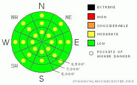
There is a LOW danger on most slopes in the backcountry, and you'll find generally safe avalanche conditions. There may be a few isolated and very steep slopes in exposed upper elevation terrain where you could trigger wind slab avalanches, and I've included pockets with a MODERATE danger on a few drifted slopes at upper and mid-elevations. Also, midday solar heating will cause an increasing danger of shallow wet avalanches on steep sunny slopes with saturated surface snow.
Continue to practice good travel habits and evaluate the snow and terrain as you go. |
|
|
CURRENT CONDITIONS |

|
Should be a fine warm and sunny day in the backcountry, and pre-dawn mountain temperatures are already rising. You'll find plenty of slopes with nice shallow powder on a pleasantly smoothed-in base, especially at upper elevations in the Central Bear River Range. Turning conditions are fast and smooth, and you can ride up pretty much any hill you want to try, (as long as its in terrain open to motorized sledding.)
Its 14 degrees at the CSI Logan Peak weather station at 9700', with a 20 mph west wind. The Tony Grove Snotel at 8400' reports 89 inches of total snow on the ground, containing 99% of normal water equivalent for the date |
|
|
RECENT ACTIVITY |

|
It's been a week now since any significant slab avalanche activity occurred in the region. (observers' photos from last weekend) Sizable wet avalanches occurred on shady low and mid elevation slopes in the Logan Area Mountains and across Northern Utah with last week's warm temperatures and rain, but much colder temperatures in the past couple days locked things up.
I was able to trigger a small and quite manageable soft wind slab yesterday on a drifted gully-wall in upper elevation east facing terrain...It was about a foot deep and 20' wide... |
|
|
THREAT #1 |

|
| WHERE |
PROBABILITY |
SIZE |
TREND |

|
|
|
|
| |
|
|
Over the next
24
hours.
|
|
|
Thursday's spike in west winds drifted substantial quantities of fresh snow, especially at upper elevations. Most wind slabs appear to have bonded fairly well to dense underlying snow. In some areas wind slabs may still be sensitive to your weight, and you could trigger avalanches on some very steep drifted slopes in the region. The stiffer wind slabs are now buried and hidden under a few inches of colder powder from late Thursday. You'll have to do a bit of investigation or "poking around" in the snow to find the slabs, which, as always, you should avoid on especially steep slopes. Pay close attention to the terrain in drifted areas, and watch out for trees or other traps like gullies of cliffs below you.
Thursday's drifting built up anew the large overhanging cornices on the major ridge-lines...Although the cornices I saw yesterday acted fairly stable; some are still likely to be sensitive to your weight. And, large cornices are notoriously tricky, often breaking further back than you might expect. |
|
|
THREAT #2 |

|
| WHERE |
PROBABILITY |
SIZE |
TREND |

|
|
|
|
| |
|
|
Over the next
8 hours.
|
|
|
Warming temperatures and direct solar heating will create a possibility of a few shallow loose wet avalanches on some steep sunny slopes with saturated surface snow. |
|
|
THREAT #3 |

|
| WHERE |
PROBABILITY |
SIZE |
TREND |

|
|
|
|
| |
|
|
Over the next
24
hours.
|
|
|
You can still find a clean and sometimes energetic shear on the surface hoar layer buried intact back at the beginnning of Feburary. Triggered slab avalanches in the two to three foot deep range are rather unlikely, but still possible on a few isolated and mostly shady mid elevation slopes where this layer persists.... |
|
|
MOUNTAIN WEATHER |

|
Expect a warm and sunny day in the mountains today, with midday 9000' temperatures approaching 40 degrees. It'll warm and breezy tomorrow, with a stout south wind shifting around from the west and increasing cloudiness. A moist southwest flow will reestablish itself, and we can expect moist conditions with some snow and rain early next week. A better defined storm is possible mid-week. |
|
|
GENERAL ANNOUNCEMENTS |
Our "Know before You Go" video is available online..... (click HERE to watch it)
The UAC depends on contributions from users like you to support our work. To find out more about how you can support our efforts to continue providing the avalanche forecasting and education that you expect please visit our Friends page.
Please let us know what you're seeing in the backcountry, especially if you see or trigger an avalanche, by leaving us a message at (435-)755-3638 or 1-800-662-4140. Or, you can always e-mail us at uac@utahavalanchecenter.org. . Your observations are very important for our program.....
This advisory is from the U.S.D.A. Forest Service, which is solely responsible for its content. This advisory describes general avalanche conditions and local variations always occur.
I will update this advisory by around 7:30 Monday morning. |
|
|
This information does not apply to developed ski areas or highways where avalanche control is normally done. This advisory is from the U.S.D.A. Forest Service, which is solely responsible for its content. This advisory describes general avalanche conditions and local variations always occur. |
|
This advisory provided by the USDA Forest Service, in partnership with:
The Friends of the Utah Avalanche Center, Utah Division of State Parks and Recreation, Utah Division of Emergency Management, Salt Lake County, Salt Lake Unified Fire Authority and the friends of the La Sal Avalanche Center. See our Sponsors Page for a complete list. |
