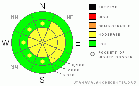
BOTTOM LINE
Danger by aspect and elevation on slopes approaching 35° or steeper.
(click HERE for tomorrow's danger rating)
|
Danger Rose Tutorial
|
There is a MODERATE danger in the backcountry, and you could trigger dangerous wind slab avalanches on some drifted slopes steeper than around 35 degrees in exposed upper and mid-elevation terrain. Avoid large overhanging cornices along the major ridge-lines, as they are quite deceitful and often break further back than expected.... You'll find a LOW danger at lower elevations and in most sheltered terrain.
Evaluate the snow and terrain carefully and use good travel habits..... |
|
|
CURRENT CONDITIONS |

|
Mountain temperatures dropped like stock options overnight, further solidifying the saturated snow from last week's warmth and rain. Winds are out of the northwest, and it is currently zero degrees at 9700', as recorded by the Campbell Scientific Logan Peak weather station.
This time we're the big statewide winners of the snowfall lottery, with another nice even shot of 5 inches recorded by all the Central Bear River Range Snotels and Beaver Mountain's remote snow depth sensor. The Tony Grove Snotel reports 4/10ths of an inch of water accumulation in the last 24 hours and 1.3 inches in the last 72....
You'll find nice, freshly smoothed in, mid-winter powder conditions in the Bear River Range this morning, especially at upper elevations. |
|
|
RECENT ACTIVITY |

|
It's been a week now since any significant slab avalanche activity occurred in the region. (observers' photos from last weekend)
Sizable wet avalanches occurred on shady low and mid elevation slopes in the Logan Area Mountains and across Northern Utah with last week's warm temperatures and rain.
There have been few reports and none of avalanches from the local backcountry in the past few days..... |
|
|
THREAT #1 |

|
| WHERE |
PROBABILITY |
SIZE |
TREND |
|
|
|
|
| |
|
|
Over the next
24
hours.
|
|
|
Yesterday's spike in west winds definitely drifted substantial quantities of fresh snow, especially at upper elevations. In some areas wind slabs may be sensitive to your weight, and you could trigger avalanches on some steep drifted slopes in the region. Stiffer wind slabs are now buried and hidden under a few inches of colder powder. You'll have to do a bit of investigation or "poking around" in the snow to find the slabs, which, as always, you should avoid on steep slopes. |
|
|
THREAT #2 |

|
| WHERE |
PROBABILITY |
SIZE |
TREND |
|
|
|
|
| |
|
|
Over the next
24
hours.
|
|
|
Yesterday's drifting built up anew the large overhanging cornices on the major ridge-lines...As they are readjusting to their new loads and shapes; these cornices are likely to be sensitive to your weight. And, large cornices are notoriously tricky, often breaking further back than you might expect. Cornice-falls today could trigger wind slab avalanches on steep slopes below... |
|
|
MOUNTAIN WEATHER |

|
The cold front will move eastward and out of the region this morning and a high pressure ridge will move in, bringing fair and mild weather for the weekend...Temperatures will warm up significantly tomorrow and again on Sunday, when cloud cover and south winds will bring the warmth to north facing terrain and back up to higher elevations...
A moist southwest flow will reestablish itself, and we can expect moist conditions with some snow and rain early next week. A better defined storm is possible mid-week. |
|
|
GENERAL ANNOUNCEMENTS |
Our "Know before You Go" video is available online..... (click HERE to watch it)
The UAC depends on contributions from users like you to support our work. To find out more about how you can support our efforts to continue providing the avalanche forecasting and education that you expect please visit our Friends page.
Your snow and avalanche observations help everyone in the backcountry community. Please let us know what you're seeing, especially if you see or trigger an avalanche, by leaving a message at (435-)755-3638 or 1-800-662-4140, or you can always e-mail us at uac@utahavalanchecenter.org. .
This advisory is from the U.S.D.A. Forest Service, which is solely responsible for its content. This advisory describes general avalanche conditions and local variations always occur.
I will update this advisory by around 7:30 Saturday morning. |
|
|
This information does not apply to developed ski areas or highways where avalanche control is normally done. This advisory is from the U.S.D.A. Forest Service, which is solely responsible for its content. This advisory describes general avalanche conditions and local variations always occur. |
|
This advisory provided by the USDA Forest Service, in partnership with:
The Friends of the Utah Avalanche Center, Utah Division of State Parks and Recreation, Utah Division of Emergency Management, Salt Lake County, Salt Lake Unified Fire Authority and the friends of the La Sal Avalanche Center. See our Sponsors Page for a complete list. |
