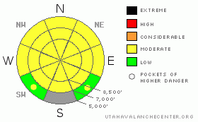
BOTTOM LINE
Danger by aspect and elevation on slopes approaching 35° or steeper.
(click HERE for tomorrow's danger rating)
|
Danger Rose Tutorial
|
There is a MODERATE danger in the backcountry, and you might trigger avalanches on slopes steeper than about 35 degrees at all elevations. Triggered wind slab avalanches are possible on mid and upper elevation slopes exposed to drifting from southwest winds, and dangerous cornice falls are possible along high ridge-lines. Wet loose and wet slab avalanches are still possible at mid and lower elevations on steep slopes with saturated snow, mostly in normally shady and sheltered areas.
This evening's storm may cause pockets with a CONSIDERABLE danger to develop overnight in some upper and mid elevation areas.
Use conservative decision making, careful route finding, and good travel protocols. |
|
|
CURRENT CONDITIONS |

|
Unfortunately, the warmth and rain in the past couple days destroyed the nice low and mid elevation powder that we had stashed in many areas last week.Even so, we found fun coastal snow conditions, with the best quality heavy fresh snow at upper elevations...
The Tony Grove Snotel at 8400' recorded 9/10ths of an inch of water accumulation in the last 48 hours, with only an inch or two of snow to show for it. Rain at 8400' in February is not all that uncommon, but it is unwelcome to us powder snobs... The station reports 85 inches of total snow containing 100% of normal water for the date.
A fairly strong southwest wind visibly drifted snow in exposed upper elevation terrain yesterday before diminishing a bit overnight. The CSI weather station at 9700' on Logan Peak shows a southwest wind increasing again this morning and posting 20+ mph hourly averages. The forecast calls for southeasterly winds today ahead of an incoming wave of moist Pacific storminess, which will begin to impact our area this afternoon with a decent shot of snowfall......
|
|
|
RECENT ACTIVITY |

|
Numerous sizable wet avalanches occurred on normally shady low and mid elevation slopes in the past couple days. Of note are the repeaters in Logan Canyon below Temple Fork and above the dugway, which gouged out all the snow to the ground again. I also noticed some fairly large wet slides above Perry and above hwy 89-91below Mantua. The largest I observed was above Dry Lake in the Wellsville Mountain Wilderness on an east facing slope. The avalanche looks to have originated in steep mid elevation terrain, and after running a bit over 1000', it spread out a large pile of heavy debris maybe 100' wide or so on the flats.....
Observers on Monday sent in some great photos of avalanches they spied over the weekend. (photos)
In the past couple days, no new triggered avalanches were reported from the now mostly quite backcountry...
|
|
|
THREAT #1 |

|
| WHERE |
PROBABILITY |
SIZE |
TREND |

|
|
|
|
| |
|
|
Over the next
24
hours.
|
|
|
Strongish and sustained southwest winds yesterday drifted the heavy new snow at upper elevations, building stiff wind slabs in lee terrain features near ridge-tops and in other deposition areas in open or exposed terrain. You might trigger wind slab avalanches on slopes steeper than about 35 degrees with freshly wind deposited snow. The large overhanging ridge-top cornices continue to build, and that means they're dangerous and devious, with a tendency for unexpectedly breaking further back from the edge then you might think.
This afternoon and evening an energetic front will zoom through the region. Accumulating snowfall will create the usual fresh snow hazards, with the danger becoming higher during periods of high precipitation rates and in areas exposed to wind drifting.
|
|
|
THREAT #2 |

|
| WHERE |
PROBABILITY |
SIZE |
TREND |
|
|
|
|
| |
|
|
Over the next
24
hours.
|
|
|
Avalanches failing on buried weak layers consisting of either surface hoar or small facets are possible on some slopes steeper than about 35 degrees. The danger appears to be the highest on low elevation slopes facing the northern half of the compass. Warming and rain on these slopes in the past couple days may have caused the situation to get more dangerous, with triggered wet/persistent slab avalanches possible in some areas.
The danger should diminish with cooling later in the week... |
|
|
THREAT #3 |

|
| WHERE |
PROBABILITY |
SIZE |
TREND |

|
|
|
|
| |
|
|
Over the next
8 hours.
|
|
|
Continuing warm temperatures today won't help with the saturated lower and mid-elevation snow, and wet avalanches are still possible today. There is still a lingering danger of wet slab avalanches on slopes plagued by persistent weak layers.
The danger should diminish with cooling later in the week... |
|
|
MOUNTAIN WEATHER |

|
A low pressure system off the California coast is pumping Pacific moisture in weak disturbances headed our way. Looks like about 6 inches possible at higher elevations this evening, with more snow possible in areas favored by the southwest flow. The cold front will pass through our region tonight. A stronger and colder storm is expected early Friday... |
|
|
GENERAL ANNOUNCEMENTS |
Our "Know before You Go" video is available online..... (click HERE to watch it)
The UAC depends on contributions from users like you to support our work. To find out more about how you can support our efforts to continue providing the avalanche forecasting and education that you expect please visit our Friends page.
Your snow and avalanche observations help everyone in the backcountry community. Please let us know what you're seeing by leaving a message at (435-)755-3638 or 1-800-662-4140, or email us at uac@utahavalanchecenter.org. .
This advisory is from the U.S.D.A. Forest Service, which is solely responsible for its content. This advisory describes general avalanche conditions and local variations always occur.
I will update this advisory by around 7:30 Friday morning. |
|
|
This information does not apply to developed ski areas or highways where avalanche control is normally done. This advisory is from the U.S.D.A. Forest Service, which is solely responsible for its content. This advisory describes general avalanche conditions and local variations always occur. |
|
This advisory provided by the USDA Forest Service, in partnership with:
The Friends of the Utah Avalanche Center, Utah Division of State Parks and Recreation, Utah Division of Emergency Management, Salt Lake County, Salt Lake Unified Fire Authority and the friends of the La Sal Avalanche Center. See our Sponsors Page for a complete list. |
