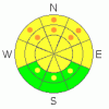
BOTTOM LINE
Danger by aspect and elevation on slopes approaching 35° or steeper.
(click HERE for tomorrow's danger rating)
|

Danger Rose Tutorial
|
Generally there is a MODERATE danger, with dangerous avalanche conditions present in some terrain features, and triggered avalanches are possible on slopes steeper than about 35 degrees. There are still pockets with a CONSIDERABLE danger on slopes with a buried persistent weak layer consisting of frost or surface hoar on shady, sheltered slopes, mainly at mid and lower elevations. A MODERATE danger of wind slab avalanches can be found in upper and mid-elevation terrain exposed to drifting from west winds, and there's an increasing danger of midday wet avalanches on slopes exposed to solar heating with saturated surface snow .
Use conservative decision making, carefull route finding, and good travel protocols. |
|
|
CURRENT CONDITIONS |

|
Perhaps the most substantial storm of the season on Tuesday dropped 28 inches of snow on the Tony Grove depth sensor with 2 inches of water in just 24 hrs, and there's now 91 inches of total snow on the ground with 98 % of normal water content at 8400'. Its 20 degrees and there's a northwest breeze at 9700' at the Campbell Scientific weather station on Logan Peak.
The new snow settled significantly in the past couple days, and avalanche conditions have stabalized on most slopes, but probably not all of them. Many steep slopes in the Central Bear River Range got nicely tested yesterday, and no triggered avalanches were reported from the area. |
|
|
RECENT ACTIVITY |

|
Natural avalanches occurred during Tuesday's furious storm across the Logan Zone at all elevations, and in most cases substantial accumulations from later in the storm now hides the evidence. Some avalanches at lower and mid-elevations may involve a persistent weak layer consisting of surface hoar or frost, buried in early February. Large avalanches have been reported or observed now in most areas, but I'm still curious and interested in what you see out there this weekend...
-Large and destructive natural avalanches ran with Tuesday's storm in most of the large run-out gullies on the east side of the Wellsville Range above Mendon and Wellsville. (2-18-09 photos)
-We took the advanced avalanche class up to the Silver Mine Canyon Area in the wilderness and examined an extensive natural cycle on north and east facing slopes between around 6000' and 7400'. (PHOTOS)
- There have been several human triggered avalanches this week, including snowmobiler triggered slides in the Tony Grove and Providence Canyon Areas and a skier or snowboarder triggered slide off the back side of Beaver Mountain.
…. |
|
|
THREAT #1 |

|
| WHERE |
PROBABILITY |
SIZE |
TREND |
|
|
|
|
| |
|
|
Over the next
24
hours.
|
|
|
The preserved surface hoar layer that was buried back on February 6th may linger as a persistent weak layer reactive to human weight at lower and especially mid elevations.....
This layer only exists on generally sheltered slopes facing the northern 3/8s of the compass. Slab avalanches stepping down to this layer will be in the 2 to 3 feet deep range and may involve broad sections of a slope or entire bowls. A thin sun or radiation crust developed on Monday on some sunny slopes, and associated weaknesses may also be responsible for some slab avalanches. |
|
|
THREAT #2 |

|
| WHERE |
PROBABILITY |
SIZE |
TREND |
|
|
|
|
| |
|
|
Over the next
24
hours.
|
|
|
You should expect to find stiff and stubborn wind slabs in exposed terrain. Although probably fairly well bonded in place, these can be tricky and are much more unmanageable than the nice soft slabs we saw last weekend. Beware the huge and overhanging cornices on the major ridge-lines. These deceptive monsters are likely to break further back than you expect and could trigger wind slab avalanches on lee slopes below...... |
|
|
THREAT #3 |

|
| WHERE |
PROBABILITY |
SIZE |
TREND |

|
|
|
|
| |
|
|
Over the next
8 hours.
|
|
|
Solar heating will cause an increasing danger of sizable loose wet avalanches on any steep slope with surface snow that becomes saturated due to warmth. Triggered wet avalanches are possible, especially in sunny sheltered areas. As usual, east and southeast facing slopes will become active first, by mid morning, and then wet activity will likely move around the compass to the south and west. |
|
|
MOUNTAIN WEATHER |

|
Expect sunny skies and calm winds today as a high pressure system gradually moves eastward....Clouds will start streaming in tomorrow and south winds will increase as a moist southwest flow develops. Looks like light snow Sunday night and Monday, with periods of snowy weather continuing into the coming work week. |
|
|
GENERAL ANNOUNCEMENTS |
You can get a great deal on further discounted tickets to Beaver Mountain and support the Utah Avalanche Center at the same time. 100% of the funds raised from these donated lift tickets will go to the Friends of the Utah Avalanche Center and will help our financially strapped but important program...(Click HERE to get discounted tickets on-line).
Our "Know before You Go" video is available online..... (click HERE to watch it)
The UAC depends on contributions from users like you to support our work. To find out more about how you can support our efforts to continue providing the avalanche forecasting and education that you expect please visit our Friends page.
Your snow and avalanche observations help everyone in the backcountry community. Please let us know what you're seeing by leaving a message at (435-)755-3638 or 1-800-662-4140, or email us at uac@utahavalanchecenter.org. .
This advisory is from the U.S.D.A. Forest Service, which is solely responsible for its content. This advisory describes general avalanche conditions and local variations always occur.
I will update this advisory by around 7:30 Saturday morning. |
|
|
This information does not apply to developed ski areas or highways where avalanche control is normally done. This advisory is from the U.S.D.A. Forest Service, which is solely responsible for its content. This advisory describes general avalanche conditions and local variations always occur. |
|
This advisory provided by the USDA Forest Service, in partnership with:
The Friends of the Utah Avalanche Center, Utah Division of State Parks and Recreation, Utah Division of Emergency Management, Salt Lake County, Salt Lake Unified Fire Authority and the friends of the La Sal Avalanche Center. See our Sponsors Page for a complete list. |
