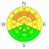
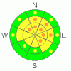
BOTTOM LINE
Danger by aspect and elevation on slopes approaching 35° or steeper.
(click HERE for tomorrow's danger rating)
|

Danger Rose Tutorial
|
Generally there is a MODERATE danger, with dangerous avalanche conditions present in some terrain features, and triggered avalanches are possible on slopes steeper than about 35 degrees. There is still a CONSIDERABLE danger on slopes with a buried persistent weak layer consisting of frost or surface hoar on shady, sheltered slopes, mainly at mid elevations. Pockets with a CONSIDERABLE danger of wind slab avalanches can be found in upper and mid-elevation terrain exposed to southwest winds, and also there's a danger of wet avalanches on slopes with saturated surface snow exposed to solar heating.
Use conservative decision making, carefull route finding, and good travel protocols. |
|
|
CURRENT CONDITIONS |

|
Perhaps the most substantial storm of the season on Tuesday dropped 28 inches of snow on the Tony Grove depth sensor with 2 inches of water in just 24 hrs, and there's now 94 inches of total snow on the ground with 99 % of normal water content at 8400'. West-southwest winds picked up overnight, with the 9700' wind sensor at the Campbell Scientific weather station on Logan Peak posting 30 mph hourly averages for several hours.
The new snow settled significantly in the past couple days, and conditions have stabalized on most slopes. So much snow fell at upper elevations that pretty much all of the hundreds of riders who ventured up above Tony Grove Lake got baddly stuck a few times before routes across the flats were well packed out. |
|
|
RECENT ACTIVITY |

|
Snowmobiler triggered avalanches were reported on Tuesday in the Tony Grove Area and Wednesday in the Providence Canyon Area, and thankfully, nobody got caught or injured. Natural avalanches occurred during the furious storm across the Logan Zone at all elevations, and in most cases substantial accumulations from later in the storm now hides the evidence. Some avalanches at lower and mid-elevations may involve a persistent weak layer consisting of surface hoar or frost, buried in early February.
-Large and destructive natural avalanches ran with Tuesday's storm in most of the large run-out gullies on the east side of the Wellsville Range above Mendon and Wellsville. (2-18-09 photos) A couple others reported in the Silver Mine Canyon Area on northeast facing slopes at around 7000' looked to be a couple hundred feet wide, running 800-1000'.
- An observer reported a natural wind slab avalanche from late in the storm near the mouth of Green Canyon (NNW ~6800)', approx. 1' deep and 200' wide, running around 800'. This one stopped a couple hundred feet short of the Green Canyon road below the trailhead.
…. |
|
|
THREAT #1 |

|
| WHERE |
PROBABILITY |
SIZE |
TREND |
|
|
|
|
| |
|
|
Over the next
24
hours.
|
|
|
The preserved surface hoar layer that was buried back on February 6th may linger as a persistent weak layer reactive to human weight at lower and especially mid elevations.....
This layer only exists on generally sheltered slopes facing the northern 3/8s of the compass. Slab avalanches stepping down to this layer will be in the 2 to 3 feet deep range and may involve broad sections of a slope or entire bowls. A thin sun or radiation crust developed on Monday on some sunny slopes, and associated weaknesses may also be responsible for some slab avalanches. |
|
|
THREAT #2 |

|
| WHERE |
PROBABILITY |
SIZE |
TREND |
|
|
|
|
| |
|
|
Over the next
24
hours.
|
|
|
Winds intensified overnight and stayed consistent from the west-southwest. You should expect to find stiff and stubborn wind slabs in exposed terrain. Although probably fairly well bonded in place, these can be tricky and are much more unmanageable than the nice soft slabs we saw last weekend.
Beware the huge and overhanging cornices on the major ridge-lines. These deceptive monsters are likely to break further back than you expect and could trigger wind slab avalanches on lee slopes below...... |
|
|
THREAT #3 |

|
| WHERE |
PROBABILITY |
SIZE |
TREND |

|
|
|
|
| |
|
|
Over the next
8 hours.
|
|
|
Solar heating will cause an increasing danger of sizable loose wet avalanches on any steep slope with significant fresh snow that becomes saturated due to warmth. Natural avalanches are possible, especially in sunny sheltered areas.
East and southeast facing slopes will become active first, by mid morning, and then wet activity will likely move around the compass to the south and west. |
|
|
MOUNTAIN WEATHER |

|
Expect clear skies as a high pressure system sets up for the weekend....
A series of storm systems will move through the region beginning early next week. |
|
|
GENERAL ANNOUNCEMENTS |
You can get a great deal on further discounted tickets to Beaver Mountain and support the Utah Avalanche Center at the same time. 100% of the funds raised from these donated lift tickets will go to the Friends of the Utah Avalanche Center and will help our financially strapped but important program...(Click HERE to get discounted tickets on-line).
Our "Know before You Go" video is available online..... (click HERE to watch it)
The UAC depends on contributions from users like you to support our work. To find out more about how you can support our efforts to continue providing the avalanche forecasting and education that you expect please visit our Friends page.
Your snow and avalanche observations help everyone in the backcountry community. Please let us know what you're seeing by leaving a message at (435-)755-3638 or 1-800-662-4140, or email us at uac@utahavalanchecenter.org. .
This advisory is from the U.S.D.A. Forest Service, which is solely responsible for its content. This advisory describes general avalanche conditions and local variations always occur.
I will update this advisory by around 7:30 Saturday morning. |
|
|
This information does not apply to developed ski areas or highways where avalanche control is normally done. This advisory is from the U.S.D.A. Forest Service, which is solely responsible for its content. This advisory describes general avalanche conditions and local variations always occur. |
|
This advisory provided by the USDA Forest Service, in partnership with:
The Friends of the Utah Avalanche Center, Utah Division of State Parks and Recreation, Utah Division of Emergency Management, Salt Lake County, Salt Lake Unified Fire Authority and the friends of the La Sal Avalanche Center. See our Sponsors Page for a complete list. |
