Logan Avalanche Advisory

Forecaster: Toby Weed

BOTTOM LINE

Danger by aspect and elevation on slopes approaching 35° or steeper.
(click HERE for tomorrow's danger rating)


Danger Rose Tutorial

There is a CONSIDERABLE danger in the backcountry, and dangerous avalanche conditions still exist on many slopes today. Dangerous persistent slab avalanches, releasing on buried weak layers are possible on slopes steeper than around 35 degrees, especially on generally sheltered mid-elevation slopes facing the northern half of the compass. You could trigger wind slabs and loose snow avalanches involving significant quantities of Tuesday's fresh snow on steep slopes at any elevation. Avoid huge and deceptive overhanging cornices, which may break further back than you expect. The danger of significant loose wet avalanches will rise with midday solar heating, especially on sunny slopes, but possibly also in shady low elevation areas.

Use consevative decision making, carefull route finding, and good travel protocols.


CURRENT CONDITIONS

Perhaps the most substantial storm of the season on Tuesday dropped 28 inches of snow on the Tony Grove depth sensor with 2 inches of water in just 24 hrs, and there's now 98 inches of total snow on the ground with 100 percent of normal water content at 8400'.


RECENT ACTIVITY

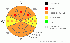
Growing list of backcountry avalanches from Tuesday's Storm:

-Observers report triggering a few fairly wide soft slab avalanches, consisting of rapidly accumulating new snow on normally sunny slopes in the steep benches above Tony Grove Lake. These, on south and southwest? facing slopes were a foot or two deep and 100' to 150' wide. Deep, deep snow kept me and everyone else from getting anywhere above the lake on Wednesday...

-Most large paths on the east side of the Wellsville Range above Mendon and Wellsville produced large natural avalanches with Tuesday's storm, and some may have avalanched a couple times.....inc. Bird Canyon 3000' vert, 20 degree Alpha, ran way onto Maple Bench and took out several old Big Tooth maples.....Gibson Canyon (twice)....Old Logway, N.Hell's, Hell's etc.....

- Observers report a couple natural avalanches visible from hwy 89-91 in Wellsville Canyon, both in the Silver Mine Canyon Area, looked to be a couple hundred feet wide, running 800-1000'.

- An observer reports a wind slab avalanche near the mouth of Green Canyon (NNW ~6800)', approx. 1' deep and 200' wide, running around 800'.

- Evidence of a significant natural slab avalanche from Tuesday is visible in Beaver Creek Canyon across hwy 89 from Backside parking. This, on a NNW facing slope at around 6700' was 1-2' deep and a couple hundred feet wide and may well have failed on a suspect surface hoar layer buried on Feb. 6th........

….


THREAT #1

WHERE PROBABILITY SIZE TREND
      Over the next 24 hours.

The preserved surface hoar layer that was buried back on February 6th may become reactive to human weight; with significant new loading of heavy wet snow at lower and especially mid elevations.....

This layer only exists on generally sheltered slopes facing the northern 3/8s of the compass.Slab avalanches stepping down to this layer will be in the 2 to 3 feet deep range and may involve broad sections of a slope or entire bowls. A thin sun or radiation crust developed on Monday on some sunny slopes, and associated weaknesses may be responsible for some slab avalanches.


THREAT #2

WHERE PROBABILITY SIZE TREND
      Over the next 24 hours.

Winds diminished with the last several inches of snowfall and widespread wind slabs built Tuesday may not be so obvious...Expect these spread over broad lee slope deposition areas and not just limited to ridge-top environs, as heavy snowfall occurred in conjunction with moderately strong winds. Significant loose avalanches and sizable soft slabs consisting of Tuesday's fresh snow and failing on Monday's interface or on generally short-lived weak density-change layers within the new snow are still possible on many slopes steeper than about 35 degrees today.

Beware the huge and overhanging cornices on the major ridge-lines. These are likely to break further back than you might expect and could easily trigger slab avalanches on lee slopes below......


THREAT #3

WHERE PROBABILITY SIZE TREND
      Over the next 8 hours.

Solar heating will cause an increasing danger of significant loose wet avalanches on any steep slope with siqnificant new snow that becomes saturated due to midday warming.


MOUNTAIN WEATHER

Expect clear skies as a high pressure system sets up for the weekend....

A series of storm systems will move through the region beginning early next week.


GENERAL ANNOUNCEMENTS

You can get a great deal on further discounted tickets to Beaver Mountain and support the Utah Avalanche Center at the same time. 100% of the funds raised from these donated lift tickets will go to the Friends of the Utah Avalanche Center and will help our financially strapped but important program...(Click HERE to get discounted tickets on-line).

Our "Know before You Go" video is available online..... (click HERE to watch it)

The UAC depends on contributions from users like you to support our work. To find out more about how you can support our efforts to continue providing the avalanche forecasting and education that you expect please visit our Friends page.

Your snow and avalanche observations help everyone in the backcountry community. Please let us know what you're seeing by leaving a message at (435-)755-3638 or 1-800-662-4140, or email us at uac@utahavalanchecenter.org. .

This advisory is from the U.S.D.A. Forest Service, which is solely responsible for its content. This advisory describes general avalanche conditions and local variations always occur.

I will update this advisory by around 7:30 Friday morning.


This information does not apply to developed ski areas or highways where avalanche control is normally done.  This advisory is from the U.S.D.A. Forest Service, which is solely responsible for its content. This advisory describes general avalanche conditions and local variations always occur.


This advisory provided by the USDA Forest Service, in partnership with:

The Friends of the Utah Avalanche Center, Utah Division of State Parks and Recreation, Utah Division of Emergency Management, Salt Lake County, Salt Lake Unified Fire Authority and the friends of the La Sal Avalanche Center. See our Sponsors Page for a complete list.