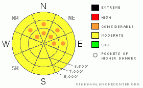
BOTTOM LINE
Danger by aspect and elevation on slopes approaching 35° or steeper.
(click HERE for tomorrow's danger rating)
|
Danger Rose Tutorial
|
Generally, there's a MODERATE danger and dangerous avalanche conditions exist on some slopes steeper than about 35 degrees in the region. The danger is higher and I've included pockets with a CONSIDERABLE danger in areas that received a foot or more of new snow yesterday and the night before, like the Wellsville Range and perhaps western slopes of the Southern Bear River Range. Loose snow, soft wind slab, and persistent slab avalanches are all more likely in these areas. The danger is lower in the Central Bear River Range where much less snow fell, but triggered avalanches are possible on some steep slopes, and I've included pockets with a MODERATE danger.
You'll find safer conditions today in lower angled or normally sunny terrain. Evaluate the snow and terrain carefully and, as always, continue to use good travel habits.... |
|
|
CURRENT CONDITIONS |

|
The Bear River Mountains were mostly left out of the storm show that dropped a couple feet in some areas in the WasatchRange. The Tony Grove Snotel reports only 3/10s of an inch of water in the last 48 hrs, with similar amounts recorded at the USUDoc Daniel Snotel (4/10s of an inch) and even less up at Franklin Basin.
Problem is that the Ben Lomond Peak Snotel above North Ogden reported 4" of water equivalent, ten times as much weight (or snow) as central parts of the Bear River Range. Given this information, I'm thinking the Wellsville Range in particular and perhaps the western slopes of the Southern Bear River Range picked up significantly more snow than we did elsewhere....
The winds have been surprisingly light, even calm in the last 24 hrs. The CSIweather station on Logan Peak reports a 5 mph north wind this morning, and it is 11 degrees at 9700' |
|
|
RECENT ACTIVITY |

|
Ski areas and highway snow safety crews in the Wasatch Range reported numerous triggered and some natural avalanches with yesterday's heavy snowfall and southwest winds. (Ogden Area Advisory)
Locally, no significant avalanches have been reported or observed recently. Yesterday, my party triggered a number of quite manageable and harmless dry sluffs or loose snow avalanches. Some of these ran pretty far, entraining the surface powder. At one point, one of our larger intentionally triggered sluffs sympatheticallytriggered a few others a good distance away, which indicates the presence of a weak layer. |
|
|
THREAT #1 |

|
| WHERE |
PROBABILITY |
SIZE |
TREND |
|
|
|
|
| |
|
|
Over the next
24
hours.
|
|
|
In areas where more than a foot of new snow accumulated, like in the Wellsville Range and perhaps the western slopes of the Southern Bear River Range, dangerous avalanche conditions exist on many slopes steeper than about 35 degrees. Watch for soft wind slabs in exposed terrain and slopes with significant deposits of new snow, which may not have bonded well to the underlying surface. Loose snow avalanches are likely on steep slopes and could entrain a significant amount of snow.
Any increase in wind speeds will cause extensive drifting and a rising danger of wind slab avalanches. |
|
|
THREAT #2 |
|
|
| WHERE |
PROBABILITY |
SIZE |
TREND |
|
|
|
|
| |
|
|
Over the next
24
hours.
|
|
|
The danger is lower in the Central Bear River Range, with triggered avalanches possible on some slopes steeper than about 35 degrees. Loose snow avalanches appear to be the most probable, but shallow soft wind slabs are also possible in some exposed areas.
Any increase in wind speeds will cause extensive drifting and a rising danger of wind slab avalanches. |
|
|
THREAT #3 |

|
| WHERE |
PROBABILITY |
SIZE |
TREND |
|
|
|
|
| |
|
|
Over the next
24
hours.
|
|
|
Yesterday's new snow is overloading a weak layer consisting of frost crystals or surface hoar in some areas, which in some cases appears to be quite well preserved under a couple inches of snow from Friday. (photo)
Small near surface facets, also only shallowly buried, make up another weak layer that is a concern as a new slab develops with additional accumulations in the next couple days...
I've added pockets of CONSIDERABLE on upper and mid elevation shady slopes only to cover areas that I suspect received significant snowfall yesterday, like the Wellsville Range and perhaps western slopes of the southern Bear River Mountains. |
|
|
MOUNTAIN WEATHER |

|
Snowfall could continue for a little while this morning, but accumulations will be light as the storm system moves off to the east. We'll see some clearing this afternoon before more clouds stream in ahead of the next system, which will affect the region Wednesday night and Thursday. Looks like the heart of this next storm will be to our south once again, but we'll probably get a bit more snow. Another storm on a similar track will impact the region over the weekend, and a moist and unsettled weather pattern should continue into next week. |
|
|
GENERAL ANNOUNCEMENTS |
Our "Know before You Go" video is available online..... (click HERE to watch it)
This advisory is from the U.S.D.A. Forest Service, which is solely responsible for its content. This advisory describes general avalanche conditions and local variations always occur.
I will update this advisory by around 7:30 Wednesday morning. |
|
|
This information does not apply to developed ski areas or highways where avalanche control is normally done. This advisory is from the U.S.D.A. Forest Service, which is solely responsible for its content. This advisory describes general avalanche conditions and local variations always occur. |
|
This advisory provided by the USDA Forest Service, in partnership with:
The Friends of the Utah Avalanche Center, Utah Division of State Parks and Recreation, Utah Division of Emergency Management, Salt Lake County, Salt Lake Unified Fire Authority and the friends of the La Sal Avalanche Center. See our Sponsors Page for a complete list. |
