AVALANCHE WARNING »
Dangerous avalanche conditions are occuring or are imminent.
Backcountry travel in avalanche terrain is not recommended.
|
 |
Notice: THIS AVALANCHE WARNING IS FOR THE WASATCH MOUNTAINS FROM THE IDAHO BORDER SOUTH TO MOUNT NEBO. HEAVY SNOWFALL HAS RESULTED IN NATURAL AVALANCHE ACTIVITY AND AVALANCHES ARE LIKELY TO CONTINUE THROUGH TUESDAY MORNING. |
|
|
BOTTOM LINE
Danger by aspect and elevation on slopes approaching 35° or steeper.
(click HERE for tomorrow's danger rating)
|
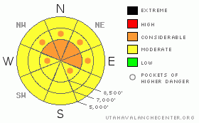
Danger Rose Tutorial
|
There is a MODERATE danger in the backcountry, and dangerous avalanche conditions exist or are developing on some slopes steeper than around 35 degrees. You could trigger new snow or persistent slab avalanches in areas with significant deposits of fresh or drifted new snow, especially at upper elevations and on slopes facing the northeastern half of the compass.
The danger will increase further as more snow stacks up, and there are already areas with pockets approaching a CONSIDERABLE danger on upper elevation slopes favored by a southwest flow, especially those with a foot or more of accumulation since yesterday. (2/9/09-) The danger has risen to CONSIDERABLE at upper and mid elevations in the Wellsville Range and on the western slopes of the Bear River Range, where more snow fell today.
You'll find safer conditions today at lower elevations and in lower angled or normally sunny terrain. Evaluate the snow and terrain carefully and, as always, continue to use good travel habits.... |
|
|
CURRENT CONDITIONS |

|
The Tony Grove Snotel reported about 4 inches of new snow since yesterday evening, containing 3/10ths of an inch of water equivalent. There is 72 inches on the total snow stake containing 94% of normal water for the date.
The weekend's east winds shifted around from the southwest yesterday evening. The Campbell Scientific weather station on Logan Peak recorded west-southwest winds averaging in the 15 mph range overnight, with gusts to around 30. The station currently shows 15 mph west winds and its 17 degrees at 9700'. |
|
|
RECENT ACTIVITY |

|
Local observations from the weekend include long running, but harmless loose snow sluffs and smallish natural cornice falls....Otherwise; folks have been reporting mostly stable snow and pretty good shallow powder conditions. |
|
|
THREAT #1 |

|
| WHERE |
PROBABILITY |
SIZE |
TREND |

|
|
|
|
| |
|
|
Over the next
24
hours.
|
|
|
As new snow piles up in the mountains today, the avalanche danger will rise. Watch for all the usual, mostly manageable problems with storm snow. Despite the fairly light winds, soft wind slabs are developing in exposed terrain, and you should avoid steep slopes with drifted or wind deposited snow. You'll also probably be able to trigger loose snow sluffs on steep slopes, and some of these could entrain a surprising amount of dry snow. |
|
|
THREAT #2 |

|
| WHERE |
PROBABILITY |
SIZE |
TREND |

|
|
|
|
| |
|
|
Over the next
24
hours.
|
|
|
Last night's and today's new snow is overloading a weak layer consisting of frost crystals or surface hoar, which in some cases appears to be quite well preserved under a couple inches of snow from Friday. (photo)
Small near surface facets, also only shallowly buried, make up another weak layer that is a concern as a new slab develops with additional accumulations in the next couple days...
The danger of persistent slabs will increase further as more snow stacks up and may already be approaching CONSIDERABLE on slopes favored by a southwest flow, especially those with several inches to a foot or more of accumulation since yesterday. |
|
|
MOUNTAIN WEATHER |

|
Expect snowfall to wind down a bit around midday and then resume again in earnest this evening. A Pacific storm system will move over the region later this evening and tonight, with a cold front bringing snow and a drop in temperatures. Snowfall should taper off tomorrow, but another storm system will follow for Wednesday night into Thursday. |
|
|
GENERAL ANNOUNCEMENTS |
Our "Know before You Go" video is available online..... (click HERE to watch it)
This advisory is from the U.S.D.A. Forest Service, which is solely responsible for its content. This advisory describes general avalanche conditions and local variations always occur.
I will update this advisory by around 7:30 Wednesday morning. |
|
|
This information does not apply to developed ski areas or highways where avalanche control is normally done. This advisory is from the U.S.D.A. Forest Service, which is solely responsible for its content. This advisory describes general avalanche conditions and local variations always occur. |
|
This advisory provided by the USDA Forest Service, in partnership with:
The Friends of the Utah Avalanche Center, Utah Division of State Parks and Recreation, Utah Division of Emergency Management, Salt Lake County, Salt Lake Unified Fire Authority and the friends of the La Sal Avalanche Center. See our Sponsors Page for a complete list. |
