BOTTOM LINE
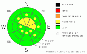
Danger by aspect and elevation on slopes approaching 35° or steeper.
(click HERE for tomorrow's danger rating)
|
Danger Rose Tutorial
|
Some new snow accumulation and fairly strong westerly winds will cause the danger to rise to MODERATE today on steep drifted slopes in exposed terrain, as wind slab avalanches become increasingly possible.
Evaluate the snow and terrain carefully and, as always, continue to use good travel habits.... |
|
|
CURRENT CONDITIONS |

|
A weakening storm is affecting the region this morning, finally breaking up the smog that choked Cache Valley for much of the week. It's mild, windy, raining this morning at my house and snowing in the mountains. As of 5:00 am, the Tony Grove Snotel reports an inch of new snow from early this morning, and is approaching a total snow reading of 70 inches.
The Campbell Scientific weather station on Logan Peak recorded south winds averaging in the 30 mph range for several hours overnight, with gusts to around 60. This morning, they've diminished a bit, (15 to 20mph) and switched around, now more from the West. It's currently 20 degrees at 9700'. |
|
|
RECENT ACTIVITY |

|
Skiers triggered a couple small wind slabs on exposed upper elevation slopes in the Central Wasatch yesterday.
Locally, last weekend a snowmobiler triggered and was caught and carried by a persistent wind slab avalanche in White Pine Canyon. Luckily, he wasn't buried or injured. The avalanche, on an east facing slope at around 8300' in elevation was around 2' deep and 75' wide. (photo)
In the past few days, there have been a good number of fairly sizable loose wet avalanches on southeast through southwest facing slopes in the region caused by midday solar heating. (2-3-09 photos) |
|
|
THREAT #1 |

|
| WHERE |
PROBABILITY |
SIZE |
TREND |

|
|
|
|
| |
|
|
Over the next
24
hours.
|
|
|
Strong south winds yesterday and overnight built stiff drifts with the little bit of available transportable old snow. These are isolated to exposed terrain near ridge-lines or on the downwind edges of large meadows or openings. Some accumulation of heavy snow is expected today while southwest winds continue singing, and fresh snow will be drifted into lee slope deposition areas. This will cause an increasing danger of soft wind slab avalanches. While windy, the amount of accumulation areas receive will directly affect the rise in avalanche danger. |
|
|
MOUNTAIN WEATHER |

|
A weakening storm system will bring a period of storminess and some snow to the mountains this morning, but it'll be somewhat short lived. Precipitation should wind down to showers by afternoon. Additional weather systems will cross through the region through the weekend and into next week. But, initially looks like most of the energy and snowfall will affect points to our south. |
|
|
GENERAL ANNOUNCEMENTS |
Our "Know before You Go" video is available online..... (click HERE to watch it)
This advisory is from the U.S.D.A. Forest Service, which is solely responsible for its content. This advisory describes general avalanche conditions and local variations always occur.
I will update this advisory by around 7:30 tomorrow morning. |
|
|
This information does not apply to developed ski areas or highways where avalanche control is normally done. This advisory is from the U.S.D.A. Forest Service, which is solely responsible for its content. This advisory describes general avalanche conditions and local variations always occur. |
|
This advisory provided by the USDA Forest Service, in partnership with:
The Friends of the Utah Avalanche Center, Utah Division of State Parks and Recreation, Utah Division of Emergency Management, Salt Lake County, Salt Lake Unified Fire Authority and the friends of the La Sal Avalanche Center. See our Sponsors Page for a complete list. |
