BOTTOM LINE
Danger by aspect and elevation on slopes approaching 35° or steeper.
(click HERE for tomorrow's danger rating)
|
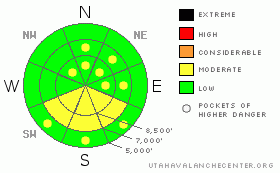
Danger Rose Tutorial
|
There is a LOW danger and the snow is generally stable on most slopes in the backcountry this morning. The danger will rise to MODERATE with midday solar heating on steep sunny slopes with saturated or slushy snow. There are still a few isolated areas on very steep, previously drifted, upper and mid-elevation north, northeast, and east facing slopes where you might trigger persistent wind slab avalanches up to about two feet deep.
Evaluate the snow and terrain carefully and, as always, continue to use good travel habits.... |
|
|
CURRENT CONDITIONS |

|
The snow on most slopes suffers from the effects of sun, wind, and tracks, but you can still find areas with fine re-crystallized or "loud powder." If you like recreating in soft snow consisting of large frost crystals or surface hoar, you'll most likely find it in sheltered shady terrain and mainly at mid and lower elevations.
It will be sunny and warm in the mountains again today, but an increasing south wind will hopefully ventilate the natural solar ovens that sunny and reflective bowls can become this time of year. It is currently 27 degrees at the 9700’ CSI weather station atop Logan Peak, with a 20 mph southwest wind. |
|
|
RECENT ACTIVITY |

|
We've still been finding evidence from last week's local natural wind slab avalanches. Although not a huge avalanche cycle by any means, some of these recent avalanches were very broad and ran quite far. (2-2-09 photos)
On Saturday a snowmobiler triggered and was caught and carried by a persistent wind slab avalanche in White Pine Canyon. Luckily, he wasn't buried or injured. The avalanche, on an east-northeast facing slope at around 8300' in elevation was around 2' deep and 75' wide. (photo)
Yesterday mid-morning, we noticed a fairly large loose wet avalanche off the southeast face of Mitten Peak in the Wellsville Range. (2-3-09 photos) A few more occurred and became apparent on steep slopes around the same general area in the heat of midday. |
|
|
THREAT #1 |

|
| WHERE |
PROBABILITY |
SIZE |
TREND |

|
|
|
|
| |
|
|
Over the next
24
hours.
|
|
|
Low danger doesn't mean no danger, and although stable conditions exist in most areas, you still might trigger avalanches on some isolated or very steep slopes in the region. Continue to evaluate the snow and terrain carefully and use wise travel techniques as a matter of course. |
|
|
THREAT #2 |

|
| WHERE |
PROBABILITY |
SIZE |
TREND |

|
|
|
|
| |
|
|
Over the next
8 hours.
|
|
|
Solar warming will cause the danger to rise around midday on steep slopes with saturated surface snow. Avoid and stay out from under sunny slopes with snow the consistancy you'd find in a 7/11 shushy.... |
|
|
THREAT #3 |

|
| WHERE |
PROBABILITY |
SIZE |
TREND |

|
|
|
|
| |
|
|
Over the next
24
hours.
|
|
|
There still could be a rogue wind slab or two out there that you might still be able to trigger. Some of last week's local avalanches stepped down to sugary weak faceted snow from the mid January high pressure system. Watch for and avoid very steep exposed slopes with stiff deposits of previously drifted snow, mainly at upper elevations and on slopes facing east, northeast, and north. |
|
|
MOUNTAIN WEATHER |

|
The high pressure system is gradually shifting to the east, and a south wind will slowly begin to increase today ahead of a series of rather weak looking storm systems. High clouds will stream into the region tomorrow and south winds will increase further. There's a good chance of some snow on Thursday night, but the system looks to be diminishing in its approach, and there's not much chance for more than a few inches of accumulation. Some weak storminess will continue through the weekend with a better chance for something significant late Monday.. |
|
|
GENERAL ANNOUNCEMENTS |
We will be down at the Backcountry Expo tonight at the Blackstone, with lots of good information about avoiding local avalanches.
The Friend's of the Utah Avalanche Center and the USU Outdoor Recreation Center will offer an Avalanche Fundamentals (level 1 certification) class This weekend on February 5,7,8. Contact the USU ORC at 797-3264 to register or for more information.
Our "Know before You Go" video is available online..... (click HERE to watch it)
This advisory is from the U.S.D.A. Forest Service, which is solely responsible for its content. This advisory describes general avalanche conditions and local variations always occur.
I will update this advisory by around 7:30 on Friday morning. |
|
|
This information does not apply to developed ski areas or highways where avalanche control is normally done. This advisory is from the U.S.D.A. Forest Service, which is solely responsible for its content. This advisory describes general avalanche conditions and local variations always occur. |
|
This advisory provided by the USDA Forest Service, in partnership with:
The Friends of the Utah Avalanche Center, Utah Division of State Parks and Recreation, Utah Division of Emergency Management, Salt Lake County, Salt Lake Unified Fire Authority and the friends of the La Sal Avalanche Center. See our Sponsors Page for a complete list. |
