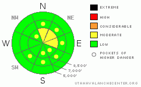
BOTTOM LINE
Danger by aspect and elevation on slopes approaching 35° or steeper.
(click HERE for tomorrow's danger rating)
|
Danger Rose Tutorial
|
There is generally a LOW danger in the backcountry, and you'll find stable snow conditions today on most slopes in the region. Exceptions and a MODERATE danger of triggering persistent wind slabs lingers on very steep upper elevation lee slopes with significant deposits of drifted snow from the middle of last week. Best to avoid large cornices and obvious drifts on steep slopes. Wet avalanches will become a possibility in the heat of the day on steep slopes with saturated surface snow.
Evaluate the snow and terrain carefully and, as always, continue to use good travel habits.... |
|
|
CURRENT CONDITIONS |

|
Its 13 degrees and a northwest wind is averaging in the lower 20 mph range and gusting to around 40 this morning at the Campbell Scientific weather station at 9700’ on Logan Peak. The Tony Grove Snotel at 8400’ reports 74 inches of total snow containing 97% of normal water for the date.
Heavy use in the backcountry over the weekend left tracks on most slopes in the popular riding areas, and there are now many crusty sunny slopes at all elevations. But, you’ll still be able to find nice stashes of fine quality powder on many shady sheltered slopes in the region. |
|
|
RECENT ACTIVITY |

|
Locally, there were numerous natural avalanches after the west wind picked up in the middle of last week. Most of these occurred on north, northeast, and east facing slopes at or above around 9000' in elevation. These ranged from medium-sized pockets (1-30-09 photo) to very broad and long running wind slab avalanches (more1-30-09 photos). A couple hazy tales of recent local triggered slides are also immerging.
Most observations that we've received from over the weekend reported good and stable snow conditions. |
|
|
THREAT #1 |

|
| WHERE |
PROBABILITY |
SIZE |
TREND |
|
|
|
|
| |
|
|
Over the next
24
hours.
|
|
|
Triggered persistent slab avalanches in the 2 to 3 foot deep range are possible on some previously drifted upper elevation slopes facing north, northeast, and east. These are most likely on very steep slopes with significant wind deposited snow from last week, and might be triggered by a cornice breaking further back than you might expect. |
|
|
THREAT #2 |

|
| WHERE |
PROBABILITY |
SIZE |
TREND |
|
|
|
|
| |
|
|
Over the next
24
hours.
|
|
|
Last week's wind built up the already huge cornices, typical for this time of year, overhanging upper elevation lee slopes. Be sure you spread your party out when you approach or traverse corniced ridge tops and stay well back from the deceptive roofs over space below. Even when everything appears stable around you, these things can often break way further back than you expect..... |
|
|
THREAT #3 |

|
| WHERE |
PROBABILITY |
SIZE |
TREND |

|
|
|
|
| |
|
|
Over the next
8 hours.
|
|
|
Midday solar heating may be enough to saturate the snow on sunny mid elevation slopes and a few smallish wet avalanches are possible on steep slopes. |
|
|
MOUNTAIN WEATHER |

|
The upper level northerly flow will weaken as a strong high pressure system moves over the region. Expect hazy valley conditions and warming at upper elevations for much of the week. A weakening system will move into the region from southern California, bringing a chance of snowfall to the mountains starting around Thursday night.... |
|
|
GENERAL ANNOUNCEMENTS |
The Friend's of the Utah Avalanche Center and the USU Outdoor Recreation Center will offer an Avalanche Fundamentals (level 1 certification) class This weekend on February 5,7,8. Contact the USU ORC at 797-3264 to register or for more information.
Our "Know before You Go" video is available online..... (click HERE to watch it)
This advisory is from the U.S.D.A. Forest Service, which is solely responsible for its content. This advisory describes general avalanche conditions and local variations always occur.
I will update this advisory by around 7:30 on Wednesday morning. |
|
|
This information does not apply to developed ski areas or highways where avalanche control is normally done. This advisory is from the U.S.D.A. Forest Service, which is solely responsible for its content. This advisory describes general avalanche conditions and local variations always occur. |
|
This advisory provided by the USDA Forest Service, in partnership with:
The Friends of the Utah Avalanche Center, Utah Division of State Parks and Recreation, Utah Division of Emergency Management, Salt Lake County, Salt Lake Unified Fire Authority and the friends of the La Sal Avalanche Center. See our Sponsors Page for a complete list. |
