BOTTOM LINE
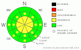
Danger by aspect and elevation on slopes approaching 35° or steeper.
(click HERE for tomorrow's danger rating)
|

Danger Rose Tutorial
|
There's a MODERATE danger in the backcountry, and dangerous avalanche conditions exist on some terrain features. You could trigger dangerous wind slab avalanches and cornice falls on upper elevation lee slopes steeper than around 35 degrees. Some avalanches could step down to weak layers formed on the snow surface during the mid-January high pressure system. Wet avalanches are possible on steep slopes with saturated, surface snow.
Evaluate the snow and terrain carefully and use good travel habits.... |
|
|
CURRENT CONDITIONS |

|
We found excellent powder conditions yesterday in sheltered and shady terrain at all elevations. Unfortunately, exposed upper elevation slopes are mostly wind-effected and rimed, and sunny slopes most certainly developed a sun-crust overnight after yesterday’s solar warming.
The Tony Grove Snotel reports 78 inches of snow, containing 99% of the normal water content for the date. The Campbell Scientific weather station on Logan Peak is recording 20 mph winds from the west-northwest, and its 20 degrees this morning at 9700'. |
|
|
RECENT ACTIVITY |

|
Tuesday night’s and Wednesday’s spike in westerly winds overloaded many lee slopes in the region, and yesterday’s clearing revealed evidence of several significant natural avalanches at upper elevations. A few fairly large slides were observed on the east side of the Wellsville Range above the town of Wellsville. The largest of these on an east facing slope at around 9000’ in elevation was estimated to be 2-3’ deep and around 600’ wide.
A backcountry party on White Pine Knob yesterday observed a fresh looking slab release on the east face of Mt. Magog. (photo). This natural avalanche on an east facing slope at around 9200' looks to be a couple feet deep and 60 or 70 feet wide, and it must have occurred late Wednesday night or Thursday.
It turns out the line I wanted to ski yesterday had avalanched earlier in the Week. The entire Music Note in upper Mill Hollow slid, and judging by the snow on the debris, this most likely occurred sometime on Wednesday after westerly winds picked up. The large wind slab avalanche on a north-northeast facing slope started at around 9000' in elevation and ran down track about 2500' vertical feet to its toe at around 6500'. It was a hard slab avalanche, 2-3+ feet deep and about 900 feet wide. A snow profile nearby showed that the avalanche probably ran on small facets that formed near the snow surface under the mid January high pressure system.(1-30-09 photos) |
|
|
THREAT #1 |

|
| WHERE |
PROBABILITY |
SIZE |
TREND |

|
|
|
|
| |
|
|
Over the next
24
hours.
|
|
|
Extensive drifting on Wednesday changed the landscape at upper elevations, and there are now huge drifts and deep, stiff, wind slabs. These now appear fairly well bonded to the underlying snow in most cases. The drifting snow also rebuilt huge existing cornices, which might break further back than you expect. A large cornice dropping onto a drifted slope below might very well be enough of a shock to trigger a wind slab avalanche. In some cases, wind slabs may pull out on last week's old snow surface, and these have the potential to be large and destructive avalanches.
Continue to avoid obvious drifts on steep slopes, and give the huge freshly built cornices wide berth. |
|
|
THREAT #2 |

|
| WHERE |
PROBABILITY |
SIZE |
TREND |

|
|
|
|
| |
|
|
Over the next
24
hours.
|
|
|
In some cases, wind slabs may pull out on persistant weak layers formed on the snow surface in mid-January, and these have the potential to be large and destructive avalanches.
|
|
|
THREAT #3 |

|
| WHERE |
PROBABILITY |
SIZE |
TREND |

|
|
|
|
| |
|
|
Over the next
24
hours.
|
|
|
Loose wet avalanches will again be possible slopes with saturated surface snow. These will most likely be slopes exposed to lots of sun, but cloud cover this afternoon could trap heat and mid and lower elevation shady slopes could also become active. |
|
|
MOUNTAIN WEATHER |

|
A dry cold front will affect the region this weekend, bringing a slight chance for some snow tonight and keeping the inversion at bay for the time being. Mountain temperatures will reach the mid thirties today and drop into the teens tonight. A strong high pressure system will control the weather for much of next week, with the next possibility of a storm coming on around Friday.... |
|
|
GENERAL ANNOUNCEMENTS |
The Friend's of the Utah Avalanche Center and the USU Outdoor Recreation Center will offer another Avalanche Fundamentals (level 1 certification) class on February 5,6,7. Contact the USU ORC at 797-3264 to register or for more information.
Our "Know before You Go" video is available online..... (click HERE to watch it)
This advisory is from the U.S.D.A. Forest Service, which is solely responsible for its content. This advisory describes general avalanche conditions and local variations always occur.
I will update this advisory by around 7:30 on Monday morning. |
|
|
This information does not apply to developed ski areas or highways where avalanche control is normally done. This advisory is from the U.S.D.A. Forest Service, which is solely responsible for its content. This advisory describes general avalanche conditions and local variations always occur. |
|
This advisory provided by the USDA Forest Service, in partnership with:
The Friends of the Utah Avalanche Center, Utah Division of State Parks and Recreation, Utah Division of Emergency Management, Salt Lake County, Salt Lake Unified Fire Authority and the friends of the La Sal Avalanche Center. See our Sponsors Page for a complete list. |

