SPECIAL ANNOUNCEMENT |
 |
The Friends of the Utah Avalanche Center and Cache Honda Yamaha invite you to attend an Avalanche Class for Snowmobilers. The class will start Thursday January 29th at 6:30 at CHY (3765 N. Hwy 91, Hyde Park), with an on-the-snow field session on Saturday, January 31st. Cost: $25 per person for both sessions or $10 for Thursday's classroom session only. To register, please contact Cache Honda Yamaha at 563-6291. |
|
|
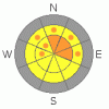
BOTTOM LINE
Danger by aspect and elevation on slopes approaching 35° or steeper.
(click HERE for tomorrow's danger rating)
|

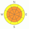
Danger Rose Tutorial
|
Thursday 1-29-09
There is a CONSIDERABLE danger in the backcountry, and dangerous avalanche conditions exist on many slopes steeper than about 35 degrees. Triggered wind slab avalanches and cornice falls are likely on slopes with recent deposits of wind-drifted snow at upper and mid-elevations. Dangerous, larger persistent slabs in the 2 to 3 foot deep range are possible, mainly at upper elevations and on steep northwest through east facing slopes. You could trigger sizable loose snow avalanches in steep terrain, and the danger of loose wet avalanches will rise with solar warming on sunny slopes, especially as temperatures warm tomorrow.
Use conservative decision making, careful route finding, and wise travel habits. Avalanche training and experience are essential.
|
|
|
CURRENT CONDITIONS |

|
(Thursday 1-29-09)-
The Tony Grove Snotel reports 11 new inches yesterday with an even inch of water equivalent. This brings the reading on the total snow stake up to 84 inches, and the snow contains 101% of the normal water for the date. The station added about five inches of water equivalent since last Thursday...
The wind sensor at the CSI weather station on Logan Peak reported westerly winds averaging in the upper twenty mph range with gusts approaching 50 mph. I'm reading 8 degrees again this morning at 9700'. |
|
|
RECENT ACTIVITY |

|
There appear to have been a good number of natural avalanches over the weekend in the backcountry around Logan. On Monday, we observed evidence of fairly extensive avalanche activity in the Tony Grove Lake Area, with the most notable, a sizable slab release off the southeast ridge of Mt. Magog. ( 1-26-09 photos )
Yesterday, I observed evidence of significant natural avalanches on the east face of Providence Peak, probably from Sunday. I also checked out a more recent appearing, and scary looking avalanche that slammed the bench in Three Terraces. No way to tell for sure, but this recent 2+' deep and 200-300' wide slab on a north-northeast facing slope at around 9300' may well have been triggered by a rider. ( 1-27-09 photos ) Remember, if you see evidence of recent natural avalanches or if you happen to trigger one, please let us know. The information you provide could save lives..... |
|
|
THREAT #1 |

|
| WHERE |
PROBABILITY |
SIZE |
TREND |
|
|
|
|
| |
|
|
Over the next
12 hours.
|
|
|
Strong northwest and west winds overnight built substantial wind slabs in exposed terrain. Watch for freshly formed drifts around and in terrain features like gullies, scoops, or cliff bands. Also expect cross-loading along sub-ridges and on slopes perpendicular to the wind. Watch for and avoid large cornices, which might break farther back than you expect. |
|
|
THREAT #2 |

|
| WHERE |
PROBABILITY |
SIZE |
TREND |
|
|
|
|
| |
|
|
Over the next
24
hours.
|
|
|
Last night's strong west winds added substantial weight to existing slabs, and the danger of persistent slab avalanches has increased. On some steep slopes, the recent snow from the weekend storm may fail on underlying sugary or faceted surface snow, and slab avalanches in the 2 to 3 foot deep range are a possibility. In most cases, the weak surface snow that formed under the recent high pressure system was destroyed by last week's warmth and wind. But there are areas where small sugary facets were left intact. I'm mostly concerned by exposed north and east facing slopes which had a thin protecting wind-crust last week.
Deep slab avalanches are also possible on isolated steep slopes today, mainly in areas with a shallow overall snowpack.. The chances of these deadly monsters reemerging has increased with the added weight of the weekend storm and last night's wind drifting. |
|
|
THREAT #3 |

|
| WHERE |
PROBABILITY |
SIZE |
TREND |

|
|
|
|
| |
|
|
Over the next
24
hours.
|
|
|
Thursday 1-29-09--
We triggered a few loose sluffs yesterday, which entrained much of the weekend's and yesterday's snow and ran fairly far and fast...When the fresh snow is heated by solar warming, loose wet avalanches will likely become a concern. |
|
|
MOUNTAIN WEATHER |

|
Strong westerly winds and snow are forecast for today, shifting from the southwest this afternoon. A high pressure system will build for the end of the week. A weak system will keep the inversion at bay on Saturday before a stronger high pressure develops for the beginning of next week. |
|
|
GENERAL ANNOUNCEMENTS |
The Friend's of the Utah Avalanche Center and the USU Outdoor Recreation Center will offer another Avalanche Fundamentals (level 1 certification) class on February 5,6,7. Contact the USU ORC at 797-3264 to register or for more information.
Our "Know before You Go" video is available online..... (click HERE to watch it)
This advisory is from the U.S.D.A. Forest Service, which is solely responsible for its content. This advisory describes general avalanche conditions and local variations always occur.
I will update this advisory by around 7:30 on Friday morning. |
|
|
This information does not apply to developed ski areas or highways where avalanche control is normally done. This advisory is from the U.S.D.A. Forest Service, which is solely responsible for its content. This advisory describes general avalanche conditions and local variations always occur. |
|
This advisory provided by the USDA Forest Service, in partnership with:
The Friends of the Utah Avalanche Center, Utah Division of State Parks and Recreation, Utah Division of Emergency Management, Salt Lake County, Salt Lake Unified Fire Authority and the friends of the La Sal Avalanche Center. See our Sponsors Page for a complete list. |
