SPECIAL ANNOUNCEMENT |
 |
The Friends of the Utah Avalanche Center and Cache Honda Yamaha invite you to attend an Avalanche Class for Snowmobilers. The class will start Thursday January 29th at 6:30 at CHY (3765 N. Hwy 91, Hyde Park), with an on-the-snow field session on Saturday, January 31st. Cost: $25 per person for both sessions or $10 for Thursday's classroom session only. To register, please contact Cache Honda Yamaha at 563-6291. |
|
|
BOTTOM LINE
Danger by aspect and elevation on slopes approaching 35° or steeper.
(click HERE for tomorrow's danger rating)
|
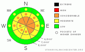
Danger Rose Tutorial
|
There is a CONSIDERABLE danger and dangerous avalanche conditions exist on many slopes steeper than about 35 degrees at upper elevations. Soft slab avalanches consisting of the weekend's snow in the 2' deep range are possible in some areas... Deep slab avalanches are also possible on very steep slopes with shallow overall snow cover. It is less dangerous today at mid and lower elevations and in lower angled terrain. |
|
|
CURRENT CONDITIONS |

|
The Tony Grove Snotel reported 14 new inches yesterday, bringing the reading on the total snow stake up to 76 inches. The station reports 100% of normal water content and added 3.5 inches of water equivalent since Thursday....I'm reading 5 degrees this morning at 9700'. The wind sensor at the CSI weather station on Logan Peak appears to be rimed over, but westerly winds have been fairly light throughout the weekend...
Thankfully, temperatures and the rain/snow line finally dropped yesterday, and snow densities lightened up as snowfall diminished yesterday evening. As the rain/snow line stayed fairly high for the first part of the weekend, you'll find significantly more new snow at upper elevations. You should find good powder conditions today, but don't let the good snow and improving weather fool you into a false sense of security. As usual, the snowpack needs a little time to adjust to it's new load. |
|
|
RECENT ACTIVITY |

|
Avalanche control for highways and ski areas in the Wasatch Range and the Ogden Area Mountains did produce some pretty good sized avalanches, but no one is surprised by the results...
Since Friday's wet activity, (1-23-09 photos), no significant avalanches have been reported in the Logan Area.... |
|
|
THREAT #1 |

|
| WHERE |
PROBABILITY |
SIZE |
TREND |

|
|
|
|
| |
|
|
Over the next
24
hours.
|
|
|
On some steep slopes, the heavy new snow from the last three days may fail on underlying sugary or faceted surface snow, and slab avalanches in the 2 foot deep range are a possibility. In most cases, the weak surface snow that formed under the recent high pressure system was destroyed by last week's warmth and wind. But there are areas where small sugary facets were left intact. I'm mostly concerned by slopes which had a thin protecting wind-crust.
Deep slab avalanches are possible on some steep slopes today, mainly in areas with a shallow overall snowpack.. The chances of these deadly monsters reemerging has increased with the added weight of the weekend storm. |
|
|
THREAT #2 |

|
| WHERE |
PROBABILITY |
SIZE |
TREND |
|
|
|
|
| |
|
|
Over the next
24
hours.
|
|
|
Expect drastically more new snow from over the weekend as you go up in elevation today. Winds have mostly been on the light side throught the recent storm, but any increase in winds could cause extensive drifting of the light powder on the snow surface and a drastic increase in the potential for wind-drift avalanches. |
|
|
MOUNTAIN WEATHER |

|
Expect lingering snow showers, with a couple more inches of light snow possible today...Northwest winds should remain on the light side until tomorrow afternoon when they will drastically intensify. A return to high presure conditions is expected in the later half of the week. |
|
|
GENERAL ANNOUNCEMENTS |
The Friend's of the Utah Avalanche Center and the USU Outdoor Recreation Center will offer another Avalanche Fundamentals (level 1 certification) class on February 5,6,7. Contact the USU ORC at 797-3264 to register or for more information.
Our "Know before You Go" video is available online..... (click HERE to watch it)
This advisory is from the U.S.D.A. Forest Service, which is solely responsible for its content. This advisory describes general avalanche conditions and local variations always occur. |
|
|
This information does not apply to developed ski areas or highways where avalanche control is normally done. This advisory is from the U.S.D.A. Forest Service, which is solely responsible for its content. This advisory describes general avalanche conditions and local variations always occur. |
|
This advisory provided by the USDA Forest Service, in partnership with:
The Friends of the Utah Avalanche Center, Utah Division of State Parks and Recreation, Utah Division of Emergency Management, Salt Lake County, Salt Lake Unified Fire Authority and the friends of the La Sal Avalanche Center. See our Sponsors Page for a complete list. |
