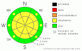
BOTTOM LINE
Danger by aspect and elevation on slopes approaching 35° or steeper.
(click HERE for tomorrow's danger rating)
|
Danger Rose Tutorial
|
There's a MODERATE danger in the backcountry, and dangerous avalanches are possible on slopes steeper than about 35 degrees in some areas, mainly on exposed upper elevation slopes. You could trigger cornice falls or wind-slab avalanches today, especially near ridge tops and in steep drifted terrain. Although gradually diminishing, the danger of triggering deadly deep slab avalanches lingers in some areas....Evaluate the snow and terrain carefully and use wise travel techniques....
|
|
|
CURRENT CONDITIONS |

|
Judging by the snow and the weather, we've reached the beginning of the mid-season. Lots of snow fell and was drifted around by strong west winds in the Bear River Mountains last week, and snow conditions are now completely different once again. You'll find good smooth and fast, shallow powder conditions on many slopes sheltered from the north wind. Breaking trail is easy, and you can ride most anywhere you want without fear of hitting rocks, with supportable snow under you now on most slopes and at all elevations...
The Tony Grove Snotel reports 26 degrees with a couple inches of new snow overnight. There's 62 inches of total snow on the ground containing 102% of the normal water weight for the date. It's 20 degrees up at 9700' on Logan Peak and a north wind appears to be increasing a bit, posting 20 mph hourly averages and gusting to 45 mph early this morning. |
|
|
RECENT ACTIVITY |

|
A natural avalanche, which pulled out to the ground was observed in the Western Uinta Mountains yesterday, on a steep east facing slope with shallow overall snow cover... The exposed slope was getting loaded up heavily by drifting snow even though it wasn't stormy.
Nobody reported any avalanche activity from over the weekend, and judging by the crowds at the trail-heads, lots of terrain was well tested......Friday, I watched from a distance as a party of snowmobilers on the ridge-top triggered a cornice-fall/wind-slab avalanche in the main bowl of Cornice Ridge...(1-9-08 photos) |
|
|
THREAT #1 |

|
| WHERE |
PROBABILITY |
SIZE |
TREND |
|
|
|
|
| |
|
|
Over the next
24
hours.
|
|
|
Large cornices built up in the last week and continue to build, and many are probably still fairly sensitive. Approach one at a time and with caution, these can break farther back than you might expect and are likely to trigger wind slab avalanches on steep slopes below. |
|
|
THREAT #2 |

|
| WHERE |
PROBABILITY |
SIZE |
TREND |
|
|
|
|
| |
|
|
Over the next
24
hours.
|
|
|
Although certainly becoming more unlikely, the terrifying possibility of triggering a deadly deep slab avalanche lingers, mostly at upper elevations and on slopes that had significant snow-cover in November...Your weight is probably not enough to trigger a deep slab in most cases because the slab is now so deep. However, this type of hard slab avalanche can sometimes be triggered from an area where the slab is shallower. |
|
|
THREAT #3 |

|
| WHERE |
PROBABILITY |
SIZE |
TREND |
|
|
|
|
| |
|
|
Over the next
24
hours.
|
|
|
Cornice build up indicates the presence of wind slabs... Although these have increasingly bonded to underlying weaknesses, you still could trigger avalanches in some areas. Watch for and avoid recently wind-deposited snow on steep slopes in exposed terrain, especially at, but not limited to, upper elevations.... |
|
|
MOUNTAIN WEATHER |

|
A ridge of high pressure has set up over the West Coast, and we're on the down slope side. We'll be under a moist north flow for the next few days, with storms passing to our north but perhaps giving us some snowfall, (especially in the Bear River Mountains) over the next couple days. Winds should to begin to diminish overnight tonight and we are likely to see hazy valley conditions begin to develop later in the week with the high pressure system moving more directly over us. |
|
|
GENERAL ANNOUNCEMENTS |
Our Level 1 avalanche class is coming up quickly, (Jan 15th 17th and 18th) contact the USU ORC to register at 435-797-3264 or at usuorc@aggiemail.usu.edu.
The Utah Avalanche Center depends on contributions from users like you to support our work....You can support the Utah Avalanche Center and get discount lift tickets to Beaver Mountain (here). All proceeds from sales will support us through the Friends of the Utah Avalanche Center....
Also the friends still have a few items left over from the Logan fundraiser and you can pick up a few killer deals right now..Here are the items that are still available: -
(2) One day passes to Park City Powder Cats to be used during January or March and before April 15th, 2009. Retail value is $449 each. Suggested Donation: $225 each
-Men's Medium Patagonia Figure 4 Jacket Grey Suggested Donation: $95
-Yamaha Leather Snowmobile Jacket Men's Medium Black with Blue marks Suggested Donation: $100
100% of your donation will support the Utah Avalanche Center. Email loganavalanche@gmail.com if you are interested in any of these items.
The information in this advisory is from the U.S.D.A. Forest Service, which is solely responsible for its content. This advisory describes general avalanche conditions and local variations always occur.
I will update this advisory by 7:30 on Wednesday morning. |
|
|
This information does not apply to developed ski areas or highways where avalanche control is normally done. This advisory is from the U.S.D.A. Forest Service, which is solely responsible for its content. This advisory describes general avalanche conditions and local variations always occur. |
|
This advisory provided by the USDA Forest Service, in partnership with:
The Friends of the Utah Avalanche Center, Utah Division of State Parks and Recreation, Utah Division of Emergency Management, Salt Lake County, Salt Lake Unified Fire Authority and the friends of the La Sal Avalanche Center. See our Sponsors Page for a complete list. |
