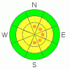
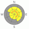
BOTTOM LINE
Danger by aspect and elevation on slopes approaching 35° or steeper.
(click HERE for tomorrow's danger rating)
|

Danger Rose Tutorial
|
Although the danger has decreased to MODERATE on most slopes in the backcountry, dangerous avalanches are still possible on slopes steeper than about 35 degrees in some areas...There are pockets with a CONSIDERABLE danger on exposed upper elevation slopes, and you could trigger cornice falls or wind-slab avalanches, especially near ridge tops and on slopes facing the eastern half of the compass...The danger of triggering deadly deep slab avalanches lingers in some areas....Use conservative decision making, careful route finding, and wise travel techniques....
You'll find safer conditions in sheltered, lower angled, and lower elevation terrain... |
|
|
CURRENT CONDITIONS |

|
Lots of snow fell and was drifted around by strong west winds in the Bear River Mountains this week, and snow conditions are completely different than they were last weekend. The Tony Grove Snotel reports 3.2 inches of water equivalent in accumulated snow over the past 5 days. There's 65 inches of total snow on the ground containing 102% of the normal water weight for the date.
Much of last week's snow is surprisingly supportable, and it's now capped by several inches of light new snow..We found smooth, fast, shallow powder conditions yesterday, once we got out of the north wind...Breaking trail is easy, and you can ride most anywhere you want, with supportable snow under you now at all elevations...I noticed that most people are still avoiding big steep hills and taking more conservative lines, which is not a bad approach to traveling in the backcountry right now...Judging by the snow, we've reached the beginning of the mid-season, and there'll be lots of time and plenty more opportunities to go big in the next couple months...
|
|
|
RECENT ACTIVITY |

|
Yesterday, I watched from a distance as a party of snowmobilers on the ridge-top triggered a cornice-fall/wind-slab avalanche in the main bowl of Cornice Ridge...(1-9-08 photos) Cornices grew significantly this week and some are clearly still sensitive....
Wednesday, a snowboarder triggered a small wind slab avalanche in the backcountry accessible from the top of Beaver Mountain, well above the Logan Canyon Highway. The avalanche, on an east-northeast facing slope at around 8000' in elevation was reported to be around 2 feet deep and 20+' wide... This is a good reminder that avalanches are possible off the backside of the Beav, and the area should definitely be treated as backcountry. In other words, be sure to carry beacons, probes, and shovels. And travel wisely, only one at a time on steep slopes, with your partners watching from a safe area.... |
|
|
THREAT #1 |

|
| WHERE |
PROBABILITY |
SIZE |
TREND |
|
|
|
|
| |
|
|
Over the next
24
hours.
|
|
|
Large cornices built up in the last week, and many are probably still fairly sensitive. Approach one at a time and with caution, these can break farther back than you might expect and are likely to trigger wind slab avalanches on steep slopes below.
Cornice build up indicates the presence of wind slabs... Although these have increasingly bonded to underlying weaknesses, you still could trigger avalanches in some areas. Watch for and avoid recently wind-deposited snow on steep slopes in exposed terrain, especially on slopes facing in an easterly direction at upper elevations.... |
|
|
THREAT #2 |

|
| WHERE |
PROBABILITY |
SIZE |
TREND |
|
|
|
|
| |
|
|
Over the next
24
hours.
|
|
|
The terrifying possibility of triggering a deadly deep slab avalanche lingers, mostly at upper elevations and on slopes that had significant snow-cover in November...Your weight is probably not enough to trigger a deep slab in most cases because the slab is now so deep, but this type of hard slab avalanche is most often triggered from an area where the slab is shallower...Also, a smaller wind slab avalanche or cornice-fall overrunning a steep slope with faceted snow on the ground could trigger a much larger and more dangerous avalanche in some places... |
|
|
MOUNTAIN WEATHER |

|
A ridge of high pressure has set up over the West Coast, and we're on the downslope side. We'll be under a moist northwestly flow for the next few days, with storms passing to our north but giving us some snowfall,(especially in the Bear River Mountains) over the next couple days. Expect somewhat sunny conditions today and temperatures in the mid-twenties in the mountains... Clouds will be increasing increasing a bit tonight, and snow showers are likely on Sunday and Monday... |
|
|
GENERAL ANNOUNCEMENTS |
Our Level 1 avalanche class is coming up quickly, (Jan 15th 17th and 18th) contact the USU ORC to register at 435-797-3264 or at usuorc@aggiemail.usu.edu.
The Utah Avalanche Center depends on contributions from users like you to support our work....You can support the Utah Avalanche Center and get discount lift tickets to Beaver Mountain (here). All proceeds from sales will support us through the Friends of the Utah Avalanche Center....
Also the friends still have a few items left over from the Logan fundraiser and you can pick up a few killer deals right now..Here are the items that are still available: -
(2) One day passes to Park City Powder Cats to be used during January or March and before April 15th, 2009. Retail value is $449 each. Suggested Donation: $225 each
-Men's Medium Patagonia Figure 4 Jacket Grey Suggested Donation: $95
-Yamaha Leather Snowmobile Jacket Men's Medium Black with Blue marks Suggested Donation: $100
100% of your donation will support the Utah Avalanche Center. Email loganavalanche@gmail.com if you are interested in any of these items.
The information in this advisory is from the U.S.D.A. Forest Service, which is solely responsible for its content. This advisory describes general avalanche conditions and local variations always occur. This advisory does not apply to ski areas or highways where avalanche control is normally conducted.
I will update this advisory by 7:30 on Monday morning. |
|
|
This information does not apply to developed ski areas or highways where avalanche control is normally done. This advisory is from the U.S.D.A. Forest Service, which is solely responsible for its content. This advisory describes general avalanche conditions and local variations always occur. |
|
This advisory provided by the USDA Forest Service, in partnership with:
The Friends of the Utah Avalanche Center, Utah Division of State Parks and Recreation, Utah Division of Emergency Management, Salt Lake County, Salt Lake Unified Fire Authority and the friends of the La Sal Avalanche Center. See our Sponsors Page for a complete list. |
