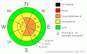
BOTTOM LINE
Danger by aspect and elevation on slopes approaching 35° or steeper.
(click HERE for tomorrow's danger rating)
|
Danger Rose Tutorial
|
There's a CONSIDERABLE danger on exposed upper elevation slopes in the backcountry, and you probably could trigger wind-slab avalanches on many slopes steeper than about 35 degrees, especially on those facing the eastern half of the compass...The danger may be higher in the Northern and Central Bear River Range, with more snowfall and winds this week...The danger of triggering deadly deep slab avalanches remains in some areas....Use conservative decision making, careful route finding, and wise travel techniques....
You'll find safer conditions in sheltered, lower angled, and lower elevation terrain... |
|
|
CURRENT CONDITIONS |

|
The mountains around Cache Valley picked up several inches yesterday evening, with the Tony Grove and Franklin Basin Snotels both reporting 8/10ths of an inch of water and 6 inches of new snow at Beaver Mountain...This will certainly help backcountry snow conditions, which were suffering a bit on many slopes from the recent warm temperatures.
Strong winds moved tons of fresh snow at upper elevations, especially in the Central and Northern Bear River Range this week, and drifting has changed the landscape... |
|
|
RECENT ACTIVITY |

|
Ski Areas in the mountains above Ogden and Salt Lake City report triggering some sizable avalanches by explosive testing yesterday...
Locally: Tuesday, a snowboarder triggered a small but significant wind slab avalanche in the backcountry accessable from the top of Beaver Mountain, well above the Logan Canyon Highway. The avalanche, on an east-northeast facing slope at around 8000' in elevation was reported to be around 2 feet deep and 20+' wide... |
|
|
THREAT #1 |

|
| WHERE |
PROBABILITY |
SIZE |
TREND |
|
|
|
|
| |
|
|
Over the next
24
hours.
|
|
|
Interesting week, weather-wise.....Cold temperatures over last weekend deposited frost crystals or surface hoar and caused the development of a thin layer consisting of weak, sugary snow near the snow surface. Then lots of nice light snow fell on Monday, and then strong westerly winds and heavy snow on Tuesday..... and then warming, strong southwest wind, rain, and heavy rimed snow on Wednesday......followed by warmth and strong southwest winds yesterday......all this capped off by a nice frosting of fresh snow overnight....
Watch for and avoid the now hidden wind-deposited snow on steep slopes in exposed terrain, especially on slopes facing in an easterly direction at upper elevations....
You will be able to find drifted areas if you dig down just a bit... |
|
|
THREAT #2 |

|
| WHERE |
PROBABILITY |
SIZE |
TREND |
|
|
|
|
| |
|
|
Over the next
24
hours.
|
|
|
The terrifying possibility of triggering a deadly deep slab avalanche lingers, mostly at upper elevations and on slopes that had significant snow-cover in November...Your weight is probably not enough to trigger a deep slab in most cases because the slab is so deep, but this type of hard slab avalanche is most often triggered from an area where the slab is shallower...Also, a smaller wind slab avalanche overrunning a steep slope with faceted snow on the ground could trigger a much larger and more dangerous avalanche in some places... |
|
|
MOUNTAIN WEATHER |

|
Temperatures and winds dropped significantly overnight in the mountains and it looks like we are in for a break in the storminess, with clearing conditions for the weekend...
A few storms will pass to our north and we may see a little snowfall from time to time, but a ridge of high pressure will gain control of the region and significant storminess is unlikely in the next week.. |
|
|
GENERAL ANNOUNCEMENTS |
|
Our Level 1 avalanche class is coming up quickly, (Jan 15th 17th and 18th) contact the USU ORC to register at 435-797-3264 or at usuorc@aggiemail.usu.edu.
The Utah Avalanche Center depends on contributions from users like you to support our work....You can support the Utah Avalanche Center and get discount lift tickets to Beaver Mountain (here). All proceeds from sales will support us through the Friends of the Utah Avalanche Center....
Also the friends still have a few items left over from the Logan fundraiser and you can pick up a few killer deals right now..Here are the items that are still available: -
(2) One day passes to Park City Powder Cats to be used during January or March and before April 15th, 2009. Retail value is $449 each. Suggested Donation: $225 each
-Men's Medium Patagonia Figure 4 Jacket Grey Suggested Donation: $95
-Yamaha Leather Snowmobile Jacket Men's Medium Black with Blue marks Suggested Donation: $100
100% of your donation will support the Utah Avalanche Center. Email loganavalanche@gmail.com if you are interested in any of these items.
|
|
|
This information does not apply to developed ski areas or highways where avalanche control is normally done. This advisory is from the U.S.D.A. Forest Service, which is solely responsible for its content. This advisory describes general avalanche conditions and local variations always occur. |
|
This advisory provided by the USDA Forest Service, in partnership with:
The Friends of the Utah Avalanche Center, Utah Division of State Parks and Recreation, Utah Division of Emergency Management, Salt Lake County, Salt Lake Unified Fire Authority and the friends of the La Sal Avalanche Center. See our Sponsors Page for a complete list. |
