SPECIAL ANNOUNCEMENT |
 |
Our Basic Avalanche class with the USU Outdoor Recreation Center starts tomorrow evening, with a field day on Saturday. Please contact the USU ORC to register or for more information at 435-797-3264 or at usuorc@aggiemail.usu.edu. |
|
|
BOTTOM LINE
Danger by aspect and elevation on slopes approaching 35° or steeper.
(click HERE for tomorrow's danger rating)
|
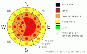
Danger Rose Tutorial
|
There's a HIGH danger and both natural and triggered avalanches are likely today on steep slopes with significant deposits of fresh heavy, wind-drifted snow. Wind-slab or fresh storm-snow avalanches are likely to be in the 1 to 3' deep range but could be broad and fairly far running. Dangerous and deadly deep slab avalanches are also possible on some upper and mid-elevation slopes. Wet avalanches will become more likely at lower and mid elevations, with continuing rain, rising rain/snow line, and warming temperatures....You should avoid travel in avalanche terrain today...Stay off of and out from under steep slopes and obvious or historic avalanche paths..... |
|
|
CURRENT CONDITIONS |

|
Unfortunately, lots of heavy, wind-drifted snow fell on top of Monday's powder, and the fresh snow is inverted, or heavier on top and lighter underneath.
The Tony Grove Snotel reports 2 inches of water in the last 48 hrs, with 1.4" in the last 24... Even as this heavy snow was accumulating, it was rapidly drifted into lee slope fetch areas and deposited in deceleration zones and around wind-breaks. The CSI weather station on Logan Peak reports consistent 20 mph west and northwest winds for the last 16 hours, with gusts of around 40.
Currently, temperatures and rain levels are rising..... |
|
|
RECENT ACTIVITY |

|
..No significant avalanches have been reported or observed locally since the active Holiday cycle...Ski Areas in the Ogden and Salt Lake Area Mountains report numerous, easily triggered soft slab avalanches yesterday on steep slopes with recently wind deposited snow...
Keep your eyes out for, and please report any potential natural or triggered avalanche activity you encounter in the backcountry today.. |
|
|
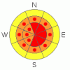
THREAT #1 |

|
| WHERE |
PROBABILITY |
SIZE |
TREND |
|
|
|
|
| |
|
|
Over the next
24
hours.
|
|
|
Lots of dense, wind-drifted snow accumulated yesterday and overnight on top of much lighter, colder snow from Monday. The fresh snow is inverted and slabby, and it now sits on weak frost crystals or surface hoar and weak snow made up of small sugary grains called near surface facets. Yesterday we triggered numerous shooting cracks in drifted snow, many over a foot deep, and I consistently found a super clean and easy shear on the interface between Friday's and Monday's snow.
Expect soft and stiffer slab avalanches consiting of recently deposited and or drifted snow in the 1 to 3' deep range...Some of these could travel far in their now filled-in paths.... |
|
|
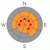
THREAT #2 |

|
| WHERE |
PROBABILITY |
SIZE |
TREND |
|
|
|
|
| |
|
|
Over the next
24
hours.
|
|
|
With very weak snow associated with the mid-November ice-crust near the ground and a stout slab in place above it, the added weight of the fresh load of snow may well be enough to cause some deep slab avalanches...The weight of a smaller soft slab avalanche overrunning a slope might be enough to cause the avalanche to step down to the now deeply buried old weak layers, creating a much more destructive and deadly hard slab avalanche.
Deep, hard slab avalanches have a tendancy to be triggered from shallow areas of the slab... |
|
|
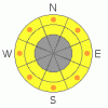
THREAT #3 |

|
| WHERE |
PROBABILITY |
SIZE |
TREND |
|
|
|
|
| |
|
|
Over the next
24
hours.
|
|
|
As the rain line creeps up in elevation and temperatures continue to rise, the danger of wet avalanches on slopes with saturated snow will increase. Watch for potential natural wet avalanches on steep slopes at low elevations, and you'll easily trigger sloppy point-releases in the fresh snow as it becomes saturated... |
|
|
MOUNTAIN WEATHER |

|
Another wave of moist snowfall will hit the region this morning and a moist flow will continue through this evening...Expect a short-lived ridge of high pressure to give us a bit of a break tonight and Thursday. The next, somewhat disorganized looking storm will affect the region beginning Thursday night. |
|
|
GENERAL ANNOUNCEMENTS |
Our Level 1 avalanche class is coming up quickly, (Jan 15th 17th and 18th) contact the USU ORC to register at 435-797-3264 or at usuorc@aggiemail.usu.edu.
The Utah Avalanche Center depends on contributions from users like you to support our work....You can support the Utah Avalanche Center and get discount lift tickets to Beaver Mountain (here). All proceeds from sales will support us through the Friends of the Utah Avalanche Center....
Also the friends still have a few items left over from the Logan fundraiser and you can pick up a few killer deals right now..Here are the items that are still available: -
(2) One day passes to Park City Powder Cats to be used during January or March and before April 15th, 2009. Retail value is $449 each. Suggested Donation: $225 each
-Men's Medium Patagonia Figure 4 Jacket Grey Suggested Donation: $95
-Yamaha Leather Snowmobile Jacket Men's Medium Black with Blue marks Suggested Donation: $100
100% of your donation will support the Utah Avalanche Center. Email loganavalanche@gmail.com if you are interested in any of these items.
If you have any observations from the backcountry, especially if you see or trigger an avalanche, please let us know. You can leave a message at (435) 755-3638 or 1-800-662-4140, or visit our Website, (utahavalanchecenter.org), and download observations directly to us.....
The information in this advisory is from the U.S.D.A. Forest Service, which is solely responsible for its content. This advisory describes general avalanche conditions and local variations always occur. |
|
|
This information does not apply to developed ski areas or highways where avalanche control is normally done. This advisory is from the U.S.D.A. Forest Service, which is solely responsible for its content. This advisory describes general avalanche conditions and local variations always occur. |
|
This advisory provided by the USDA Forest Service, in partnership with:
The Friends of the Utah Avalanche Center, Utah Division of State Parks and Recreation, Utah Division of Emergency Management, Salt Lake County, Salt Lake Unified Fire Authority and the friends of the La Sal Avalanche Center. See our Sponsors Page for a complete list. |
