SPECIAL ANNOUNCEMENT |
 |
We are offering a Basic Avalanche Class with the USU Outdoor Recreation Center this weekend, (Thursday evening classroom and Saturday in the field), contact the ORC to register at 435-797-3264 or at usuorc@aggiemail.usu.edu. |
|
|
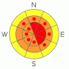
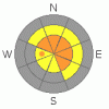
BOTTOM LINE
Danger by aspect and elevation on slopes approaching 35° or steeper.
(click HERE for tomorrow's danger rating)
|
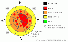
Danger Rose Tutorial
|
(1-5-09--) The backcountry avalanche danger will rise to HIGH overnight in many areas and remain high on Wednesday with warmer temperatures, heavy snow, and continuing westerly winds. Natural avalanches are probable and triggered avalanches likely, especially on slopes steeper than about 35 degrees with significant deposits of heavy or freshly drifted new snow. You should avoid steep drifted slopes at all elevations and stay off of and out from under obvious or historic avalanche paths |
|
|
CURRENT CONDITIONS |

|
West-southwest winds intensified overnight, and the Campbell Scientific Logan Peak weather station at 9700' is recording hourly average wind speeds in the mid thirties this morning, with gusts nearing 50. It is colder down here in Logan than it is up in the mountains, with zero degree readings down here, 7 degrees on Logan Peak, and 14 up at Tony Grove Lake.
Today's weather will be interesting, as a very moist, warm air-mass overruns the exceptionally cold air trapped in the lower elevations. It'll make the snow interesting too. You'll find super light powdery snow down low when you depart the trailhead. But up high, drifted by continuing and perhaps intensifying westerly winds, you'll find warmer heavier snow quickly accumulating and subsequently, an increasing avalanche danger.
Snow conditions are surprisingly supportable at all elevations, and you can easily ride most anywhere you want. Riders tested several big hills in the Central Bear River Range over the weekend, with numerous fresh tracks observed in steep upper elevation east facing terrain and no reported triggered avalanches. This is a good sign and the snow appears fairly stable in that area, but remember; just because a slope is all tracked up, doesn't mean it's necessarily safe... |
|
|
RECENT ACTIVITY |

|
Looks like a snowmobiler triggered a sizable avalanche on an east facing slope in Snake Creek Canyon above Midway. No significant avalanches were reported or observed over the weekend in the Logan Area.
In some areas, extensive natural avalanches occurred during the Christmas storm (photos 12-31-08) and in others there were only a few or none.... Many slopes have not released deep slab avalanches yet, and many of these will probably not at all. But, as new weight begins to overload steep slopes again this week, some may approach a delicate balance, and you definitely do not want to be the trigger...
-Last year's tragic fatal accident on Logan Peak was only a short time ago..(click HERE for our preliminary report)
|
|
|
THREAT #1 |

|
| WHERE |
PROBABILITY |
SIZE |
TREND |
|
|
|
|
| |
|
|
Over the next
24
hours.
|
|
|
West-southwest winds increased significantly overnight and deposited wind slabs in exposed upper and mid-elevation terrain. Winds are forecast to remain fairly strong (if not intensify) as they shift around from the northwest later today, during periods of heavy precipitation. This will likely deposit wind slabs over widespread lee terrain. The warmer, drifted snow probably won't stick well to the existing cold snow surface, which is plagued by frost or surface hoar and small grained sugary snow called near surface faceted snow.
By this afternoon, you are likely to be able to trigger fresh wind slab avalanches on many steep exposed slopes. |
|
|
THREAT #2 |

|
| WHERE |
PROBABILITY |
SIZE |
TREND |
|
|
|
|
| |
|
|
Over the next
24
hours.
|
|
|
The added weight of today's new and wind-deposited snow could be enough to overload the existing deep weak layers at the very bottom of the snowpack in some upper elevation areas. Although the weakness is so deeply buried now that it seems our weight might not be enough to do the trick, this type of avalanche can often more easily be triggered where the slab is shallow. Remember that it's possible to trigger deep slab avalanches from a distance or from below.
As snowfall and winds continue to load upper and mid-elevation slopes in the early part of this week, we'll need to keep this terrifying possibility in mind...... |
|
|
MOUNTAIN WEATHER |

|
A moist warm front will overrun the cold valley air today, and upper elevations will get a good shot of warm heavy snow and some westerly winds... 6 to 8 inches of accumulation are possible today, and simlar amounts both tonight and tomorrow. The cold air will be probably be mixed out of the valleys by tomorrow. and the National Weather Service forecasts continued significant accumulations in the mountains under this pattern through Wednesday... |
|
|
GENERAL ANNOUNCEMENTS |
Our Level 1 avalanche class is coming up quickly, (Jan 15th 17th and 18th) contact the USU ORC to register at 435-797-3264 or at usuorc@aggiemail.usu.edu.
The Utah Avalanche Center depends on contributions from users like you to support our work....You can support the Utah Avalanche Center and get discount lift tickets to Beaver Mountain (here). All proceeds from sales will support us through the Friends of the Utah Avalanche Center....
Also the friends still have a few items left over from the Logan fundraiser and you can pick up a few killer deals right now..Here are the items that are still available: -
(2) One day passes to Park City Powder Cats to be used during January or March and before April 15th, 2009. Retail value is $449 each. Suggested Donation: $225 each
-Men's Medium Patagonia Figure 4 Jacket Grey Suggested Donation: $95
-Yamaha Leather Snowmobile Jacket Men's Medium Black with Blue marks Suggested Donation: $100
100% of your donation will support the Utah Avalanche Center. Email loganavalanche@gmail.com if you are interested in any of these items.
If you have any observations from the backcountry, especially if you see or trigger an avalanche, please let us know. You can leave a message at (435) 755-3638 or 1-800-662-4140, or visit our Website, (utahavalanchecenter.org), and download observations directly to us.....
The information in this advisory is from the U.S.D.A. Forest Service, which is solely responsible for its content. This advisory describes general avalanche conditions and local variations always occur. |
|
|
This information does not apply to developed ski areas or highways where avalanche control is normally done. This advisory is from the U.S.D.A. Forest Service, which is solely responsible for its content. This advisory describes general avalanche conditions and local variations always occur. |
|
This advisory provided by the USDA Forest Service, in partnership with:
The Friends of the Utah Avalanche Center, Utah Division of State Parks and Recreation, Utah Division of Emergency Management, Salt Lake County, Salt Lake Unified Fire Authority and the friends of the La Sal Avalanche Center. See our Sponsors Page for a complete list. |
