Logan Avalanche Advisory

Forecaster: Toby Weed

SPECIAL ANNOUNCEMENT

We are offering a Basic Avalanche Class with the USU Outdoor Recreation Center this weekend, (Thursday evening classroom and Saturday in the field), contact the ORC to register at 435-797-3264 or at usuorc@aggiemail.usu.edu.


BOTTOM LINE

Danger by aspect and elevation on slopes approaching 35° or steeper.
(click HERE for tomorrow's danger rating)


Danger Rose Tutorial

A CONSIDERABLE danger lingers on some steep upper elevation slopes in the region, and you might be more likely to trigger dangerous and deadly deep slab avalanches in some areas than in others.  Elsewhere, triggered avalanches are possible and the danger is MODERATE on most slopes steeper than about 35 degrees with recent deposits of drifted snow....  You’ll find safer conditions in sheltered, lower angled and lower elevation terrain.


CURRENT CONDITIONS

The Tony Grove Snotel reported 11 inches of new snow on Friday night, containing 1.1 inches of water, and there's now 57 inches of snow on the ground at 8400'.  Temperatures climbed back to 0 degrees at Tony Grove, and I'm reading negative 4 degrees at the top of Logan Peak...9700' easterly winds at the Campbell Scientific weather station are currently fairly light (<10mph).

Snow conditions are surprisingly supportable at all elevations, and you can easily ride most anywhere you want.  Somebody certainly tested several  big hills in the Central Bear River Range yesterday, with numerous fresh tracks observed in steep upper elevation east facing terrain and no reported triggered avalanches.  This is a good sign and the snow appears fairly stable in that area, but remember;  just because a slope is all tracked up, doesn't mean it's necessarily safe...


RECENT ACTIVITY

I observed  evidence of some new natural wind slab and cornice-fall activity on the east side of the Wellsville Range.  Otherwise, no significant avalanches were reported or observed yesterday in the Logan Area. 

In some areas, extensive natural avalanches occurred during the Christmas storm (photos 12-31-08) and in others there were only a few or none.... Many slopes have not released deep slab avalanches yet, and many of these will probably not at all.  But, some may still be hanging there in a delicate balance and you do not want to be the trigger...

-Last year's tragic fatal accident on Logan Peak was only a short time ago..(click HERE for our preliminary report)


THREAT #1

WHERE PROBABILITY SIZE TREND
      Over the next 24 hours.

The added weight of the new and recent wind-deposited snow could be enough to overload the existing deep weak layers at the very bottom of the snowpack in some upper elevation areas.  Although the weakness is so deeply buried now that it seems our weight might not be enough to do the trick, this type of avalanche can often more easily be triggered where the slab is shallow.  Remember that it's possible to trigger deep slab avalanches from a distance or from below.


THREAT #2

WHERE PROBABILITY SIZE TREND
      Over the next 24 hours.

There are some recently deposted wind slabs in exposed upper and mid-elevation terrain, and you might well be able to trigger new snow avalanches on some steep slopes.


MOUNTAIN WEATHER

Clear skies overnight caused temperatures to plummet, and the Campbell Scientific weather station atop Logan Peak reports -4 degrees this morning....Expect continued cold temperatures and sunshine in the mountains today, with a bit of an inversion setting up in the Valley.  A warm-front will move into the region on Monday, bringing clouds and increasing snowfall.  The incoming storm is disorganized but moist, and a fairly good shot of snow is likely for the mountains of far northern Utah.... Expect continued moist northwest flow into mid-week...


GENERAL ANNOUNCEMENTS

Our Level 1 avalanche class is coming up quickly, (Jan 15th 17th and 18th) contact the USU ORC to register at 435-797-3264 or at usuorc@aggiemail.usu.edu.

The Utah Avalanche Center depends on contributions from users like you to support our work....You can support the Utah Avalanche Center and get discount lift tickets to  Beaver Mountain (here).  All proceeds from sales will support us through the Friends of the Utah Avalanche Center....

Also the friends still have a few items left over from the Logan fundraiser and you can pick up a few killer deals right now..Here are the items that are still available: -

(2) One day passes to Park City Powder Cats to be used during January or March and before April 15th, 2009.  Retail value is $449 each. Suggested Donation: $225 each

-Men's Medium Patagonia Figure 4 Jacket Grey    Suggested Donation: $95

-Yamaha Leather Snowmobile Jacket Men's Medium     Black with Blue marks   Suggested Donation: $100

100% of your donation will support the Utah Avalanche Center.  Email loganavalanche@gmail.com if you are interested in any of these items.

If you have any observations from the backcountry, especially if you see or trigger an avalanche, please let us know.  You can leave a message at (435) 755-3638 or 1-800-662-4140, or visit our Website, (utahavalanchecenter.org), and download observations directly to us.....

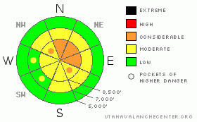
The information in this advisory is from the U.S.D.A. Forest Service, which is solely responsible for its content.  This advisory describes general avalanche conditions and local variations always occur.


This information does not apply to developed ski areas or highways where avalanche control is normally done.  This advisory is from the U.S.D.A. Forest Service, which is solely responsible for its content. This advisory describes general avalanche conditions and local variations always occur.


This advisory provided by the USDA Forest Service, in partnership with:

The Friends of the Utah Avalanche Center, Utah Division of State Parks and Recreation, Utah Division of Emergency Management, Salt Lake County, Salt Lake Unified Fire Authority and the friends of the La Sal Avalanche Center. See our Sponsors Page for a complete list.