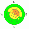
BOTTOM LINE
Danger by aspect and elevation on slopes approaching 35° or steeper.
(click HERE for tomorrow's danger rating)
|

Danger Rose Tutorial
|
There's a CONSIDERABLE danger on steep upper elevation slopes in the backcountry. Although gradually diminishing, the potential for triggering a very dangerous and destructive deep slab avalanche remains on some upper elevation slopes, mainly on those facing north and east.. It is possible to trigger one of these monsters from a distance or from a ways below it. Also, you could probably trigger wind slab avalanches in exposed upper elevation terrain, and loose wet avalanches are possible at lower elevations..
Use conservative decision making, careful route finding, and good travel techniques... Avalanche training and experience are essential..... |
|
|
CURRENT CONDITIONS |

|
Southwest winds are cranking it up a notch this morning, and the Campbell Scientific weather station on Logan Peak already recorded gusts in excess of 50 mph. Its 26 degrees at 9700' and already 33 degrees at the Tony Grove Snotel (8300')....Expect warm, wet, and windy weather in the mountains today..
You'll find fairly supportable snow conditions, and you can ride in most areas without sinking in much. Warmth and solar heating has effected mid and lower elevations, and I found nice supportable crust in lots of areas. Sheltered upper elevation slopes sport some nice soft snow conditions, but you'll have to wait till tomorrow for a taste of some 2009 vintage pow-pow.... |
|
|
RECENT ACTIVITY |

|
----Last year's tragic fatal accident on Logan Peak was only a short time ago......(click HERE for our preliminary report)
And, its been around a week since an impressive natural hard slab avalanche cycle occurred in the Logan Area backcountry. ( 12-31-08 photos) We've observed a few fresh natural wind slabs at high elevations and some loose wet avalanches at lower elevations in the past couple days, but the deep slab dragon has been resting for a little while.... |
|
|
THREAT #1 |

|
| WHERE |
PROBABILITY |
SIZE |
TREND |
|
|
|
|
| |
|
|
Over the next
24
hours.
|
|
|
Although chances of triggering a monster hard slab are diminishing as weak sugary layers near the ground gradually adjust to the weight of the overlying slab, you could still probably trigger a HUGE deadly avalanche on some big upper elevation slopes. These terrifying hard slab avalanches can be triggered from a distance or from below... |
|
|
THREAT #2 |

|
| WHERE |
PROBABILITY |
SIZE |
TREND |

|
|
|
|
| |
|
|
Over the next
24
hours.
|
|
|
Southwest winds continue to build and solidify wind slabs in exposed terrain, and you probably could trigger avalanches on many steep slopes in the region. Some of these, in steep terrain at upper and mid elevations might step down into weak layers at the very bottom of the snowpack and quickly become super dangerous deep hard slab avalanches.
Watch for and avoid obvious drifts on steep slopes, which will be smooth rounded and claulky looking, and be extra cautious around terrain features like gullies, sub-ridges, outcroppings, scoops, and under cliff bands.... |
|
|
THREAT #3 |

|
| WHERE |
PROBABILITY |
SIZE |
TREND |
|
|
|
|
| |
|
|
Over the next
24
hours.
|
|
|
I noticed a few fresh loose wet avalanches on steep north facing slopes on my way down Logan Canyon yesterday evening. Watch for moist snow on steep lower elevation slopes... |
|
|
MOUNTAIN WEATHER |

|
Expect warm, windy, and wet conditions today as a weak storm moves in from Idaho this morning, and then a strong but quick-hitter slams the region tonight. The National Weather Service has issued a Winter Weather Advisory for our area and a Winter Storm Warning for the mountains of southeast Idaho. 7 to 15 inches of accumulation is forecast at upper elevations in the Bear River Range by tomorrow morning....Some of the coldest air yet this winter will descend upon the region in the wake of tonight's cold front, so you'll need to break out the down...... |
|
|
GENERAL ANNOUNCEMENTS |
The Utah Avalanche Center depends on contributions from users like you to support our work....You can support the Utah Avalanche Center and get discount lift tickets to Beaver Mountain (here). All proceeds from sales will support us through the Friends of the Utah Avalanche Center....
Also the friends still have a few items left over from the Logan fundraiser and you can pick up a few killer deals right now..Here are the items that are still available: -
(2) One day passes to Park City Powder Cats to be used during January or March and before April 15th, 2009. Retail value is $449 each. Suggested Donation: $225 each
-Men's Medium Patagonia Figure 4 Jacket Grey Suggested Donation: $95
-Yamaha Leather Snowmobile Jacket Men's Medium Black with Blue marks Suggested Donation: $100
100% of your donation will support the Utah Avalanche Center. Email loganavalanche@gmail.com if you are interested in any of these items.
If you have any observations from the backcountry, especially if you see or trigger an avalanche, please let us know. You can leave a message at (435) 755-3638 or 1-800-662-4140, or visit our Website, (utahavalanchecenter.org), and download observations directly to us.....
The information in this advisory is from the U.S.D.A. Forest Service, which is solely responsible for its content. This advisory describes general avalanche conditions and local variations always occur. |
|
|
This information does not apply to developed ski areas or highways where avalanche control is normally done. This advisory is from the U.S.D.A. Forest Service, which is solely responsible for its content. This advisory describes general avalanche conditions and local variations always occur. |
|
This advisory provided by the USDA Forest Service, in partnership with:
The Friends of the Utah Avalanche Center, Utah Division of State Parks and Recreation, Utah Division of Emergency Management, Salt Lake County, Salt Lake Unified Fire Authority and the friends of the La Sal Avalanche Center. See our Sponsors Page for a complete list. |
