BOTTOM LINE
Danger by aspect and elevation on slopes approaching 35° or steeper.
(click HERE for tomorrow's danger rating)
|
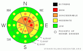
Danger Rose Tutorial
|
There's a CONSIDERABLE danger on steep slopes in the backcountry. This means you probably could trigger dangerous avalanches, especially on slopes with significant deposits of wind-drifted snow. Although diminishing somewhat, the potential for triggering a very dangerous and destructive deep slab avalanche remains on some upper elevation slopes, and it is possible to trigger one of these monsters from a distance or from a ways below it. In some areas the snow structure is weaker, and since the consequences of these potential deep slab avalanches are so severe, I've included pockets of HIGH danger at upper elevations on slopes facing east through north. |
|
|
CURRENT CONDITIONS |

|
It's 26 degrees up at Tony Grove Lake and there's a bit over 50 inches of total snow on the ground at the Snotel site... A thin rime-crust formed in the Central Bear River Range on Sunday and was subsequently covered up by a couple inches of heavy snow. The snow is surprisingly supportable, and you don't sink in very far even when you get off your sled and walk around.... |
|
|
RECENT ACTIVITY |

|
-It's been a week since the tragic fatal accident on Logan Peak...(click HERE for our preliminary report)
-A large deep slab avalanche killed a young Wyoming snowmobiler on Monday in the Western Uinta Range...........
( click HERE for Western Uintas advisory and more info)
-Ski Areas in the Wasatch Range continue to trigger large deep hard slabs with explosives
-I obseverved several large natural hard slab avalanches, which occurred durring the Christmas storms..
(Click HERE for 12-29-08 photos and HERE for 12-26-08 photos.) |
|
|
THREAT #1 |

|
| WHERE |
PROBABILITY |
SIZE |
TREND |
|
|
|
|
| |
|
|
Over the next
24
hours.
|
|
|
Strong west-southwest winds this morning cleaned the rime off the wind sensor at the CSI weather station on Logan Peak and it immediately started recording strong winds....Currently west at 40+ mph, with gusts near 50.... These winds will continue to build wind slabs in exposed terrain and you probably could trigger avalanches on many steep slopes in the region. Some of these at upper and mid elevations could step down to the bottom of the snowpack and quickly become super dangerous deep hard slab avalanches.
Watch for and avoid obvious drifts on steep slopes, which will be smooth rounded and claulky looking, and be extra cautious around terrain features like gullies, sub-ridges, outcroppings, scoops, and under cliff bands.... |
|
|
THREAT #2 |

|
| WHERE |
PROBABILITY |
SIZE |
TREND |
|
|
|
|
| |
|
|
Over the next
24
hours.
|
|
|
Although chances of triggering a monster hard slab are diminishing a bit as the weak sugary layers near the ground gradually adjust to the wieght of the overlying slab, you could still probably trigger a deadly avalanche on big upper elevation slopes in many areas.
These terrifying hard slab avalanches can be triggered from a distance or from below... As we've seen recently, any such hard slab avalanche is likely to be very large and quite destructive and perhaps deadly. |
|
|
MOUNTAIN WEATHER |

|
After a sunny start, clouds will gradually increase throughout the day...Expect upper elevation temperatures in the mid twenties. The chance of snowfall increases each period stating tonight, and going into the new year.... Looks like a potent storm Friday night into Saturday, just in time for the weekend |
|
|
GENERAL ANNOUNCEMENTS |
The UAC depends on contributions from users like you to support our work.
You can support the Utah Avalanche Center and get discount lift tickets to Beaver Mountain (here). All proceeds from sales will support us through the Friends of the Utah Avalanche Center......
If you have any observations from the backcountry, especially if you see or trigger an avalanche, please let us know. You can leave a message at (435) 755-3638 or 1-800-662-4140, or visit our Website, (utahavalanchecenter.org), and download observations directly to us.....
The information in this advisory is from the U.S.D.A. Forest Service, which is solely responsible for its content. This advisory describes general avalanche conditions and local variations always occur. |
|
|
This information does not apply to developed ski areas or highways where avalanche control is normally done. This advisory is from the U.S.D.A. Forest Service, which is solely responsible for its content. This advisory describes general avalanche conditions and local variations always occur. |
|
This advisory provided by the USDA Forest Service, in partnership with:
The Friends of the Utah Avalanche Center, Utah Division of State Parks and Recreation, Utah Division of Emergency Management, Salt Lake County, Salt Lake Unified Fire Authority and the friends of the La Sal Avalanche Center. See our Sponsors Page for a complete list. |
