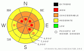
BOTTOM LINE
Danger by aspect and elevation on slopes approaching 35° or steeper.
(click HERE for tomorrow's danger rating)
|
Danger Rose Tutorial
|
Overall, there's a CONSIDERABLE danger on steep slopes in the backcountry. This means you probably could trigger dangerous avalanches, especially on slopes with significant deposits of wind-drifted snow. Although diminishing somewhat, the potential for triggering a very dangerous and destructive deep slab avalanche remains on some upper elevation slopes, and it is possible to trigger one of these monsters from a distance or from a ways below it. Since the consequences of these potential avalanches are so severe, I've included pockets of HIGH danger at upper elevations. |
|
|
CURRENT CONDITIONS |

|
Rime yesterday afternoon crusted over many upper elevation slopes and put down a good shot of water in the Central Bear River Range. It also incrusted the wind sensor on the tower at the summit of Logan Peak. West and Southwesterly winds continued to consistently crank along the higher ridges and up Logan Canyon yesterday, while the Tony Grove Snotel reports 1.2" of water equivelent in the past 24 hours and only a couple inches of snow. Several inches of super light powder fell with cold temperatures on Saturday, and I noticed significant drifting in exposed terrain yesterday.
I'm still trying to put together the details of the tragic Christmas Eve avalanche accident on Logan Peak, which killed two experienced and prepared local snowmobilers....(click HERE for our preliminary report) |
|
|
RECENT ACTIVITY |

|
There were several triggered avalanches over the weekend in the Ogden Area Mountains, the Central Wasatch and the Western Uintas, but it seems that good judgment abounded and there were no avalanche accidents...
Thankfully, no new avalanches were reported from the weekend in the Logan Area...Visibility has been poor at high elevations in the Bear River Range since the Christmas Storm, so information on natural activity is subsiquently limited... I could see evidence on Friday of a large natural hard slab avalanche in the Wellsville Range above Mendon. (photos) |
|
|
THREAT #1 |

|
| WHERE |
PROBABILITY |
SIZE |
TREND |
|
|
|
|
| |
|
|
Over the next
24
hours.
|
|
|
On many upper elevation slopes in the region, the tremendous recent weight of wind deposited snow is overloading deeply buried weak layers, and the recent additional load from the weekend could be enough to cause more avalanches to break on the basal layers of the snowpack. These terrifying hard slab avalanches can be triggered from a distance or from below... As we've seen recently, any such hard slab avalanche is likely to be very large and quite destructive and perhaps deadly. |
|
|
THREAT #2 |

|
| WHERE |
PROBABILITY |
SIZE |
TREND |
|
|
|
|
| |
|
|
Over the next
24
hours.
|
|
|
Southwest winds will continue today. Freshly wind deposited snow is often prone to avalanching on steep slopes. Softer wind slabs are generally more sensitive than stiffer ones. This might fool you into getting out on a harder slab (or out into a slope) before it releases. Watch for and avoid obvious drifts on steep slopes, which will be smooth rounded and claulky looking, and be extra cautious around terrain features like gullies, sub-ridges, outcroppings, scoops, and under cliff bands.... |
|
|
THREAT #3 |

|
| WHERE |
PROBABILITY |
SIZE |
TREND |
|
|
|
|
| |
|
|
Over the next
8 hours.
|
|
|
Watch for slides off roofs.....and loose wet avalanches on steep lower elevation slopes as temperatures rise above freezing for the first time in a while... |
|
|
MOUNTAIN WEATHER |

|
A weak storm system will affect the region today and tonight, with a few more inches of snowfall expected...Expect mild temperatures and moderate southwesterly winds today, switching to northwest overnight with temperatures in the teens. A short-lived ridge of high pressure is expected to build in for the middle part of the week before we return to a moist northwest flow... |
|
|
GENERAL ANNOUNCEMENTS |
Today would be a great day to ride up at Beaver Mountain, which just opened up last Monday. You can support the Utah Avalanche Center and get discount lift tickets (here). All proceeds from sales will support us through the Friends of the Utah Avalanche Center......
If you have any observations from the backcountry, especially if you see or trigger an avalanche, please let us know. You can leave a message at (435) 755-3638 or 1-800-662-4140, or visit our Website, (utahavalanchecenter.org), and download observations directly to us.....
The UAC depends on contributions from users like you to support our work.
The information in this advisory is from the U.S.D.A. Forest Service, which is solely responsible for its content. This advisory describes general avalanche conditions and local variations always occur. |
|
|
This information does not apply to developed ski areas or highways where avalanche control is normally done. This advisory is from the U.S.D.A. Forest Service, which is solely responsible for its content. This advisory describes general avalanche conditions and local variations always occur. |
|
This advisory provided by the USDA Forest Service, in partnership with:
The Friends of the Utah Avalanche Center, Utah Division of State Parks and Recreation, Utah Division of Emergency Management, Salt Lake County, Salt Lake Unified Fire Authority and the friends of the La Sal Avalanche Center. See our Sponsors Page for a complete list. |
