AVALANCHE WARNING »
Dangerous avalanche conditions are occuring or are imminent.
Backcountry travel in avalanche terrain is not recommended.
|
 |
Notice: DANGEROUS AVALANCHE CONDITIONS WILL PERSIST THROUGHOUT THE WEEKEND. IT IS POSSIBLE FOR BACKCOUNTRY TRAVELERS TO TRIGGER VERY LARGE AND FAR RUNNING AVALANCHES ON SLOPES STEEPER THAN ABOUT 30 DEGREES AND REMOTELY FROM A DISTANCE. PEOPLE WITHOUT EXCELLENT AVALANCHE AND ROUTE FINDING SKILLS SHOULD AVOID BACKCOUNTRY TRAVEL. THIS WARNING DOES NOT INCLUDE SKI AREAS OR HIGHWAYS WHERE AVALANCHE CONTROL IS NORMALLY DONE. |
|
|
BOTTOM LINE
Danger by aspect and elevation on slopes approaching 35° or steeper.
(click HERE for tomorrow's danger rating)
|
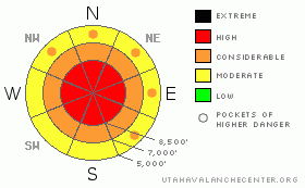
Danger Rose Tutorial
|
There’s still a HIGH danger on upper elevation slopes today. Very dangerous avalanche conditions exist on numerous slopes steeper than about 30 degrees, especially on those with significant deposits of wind-drifted snow. Triggered avalanches could break into deeply buried weak layers and be very large, dangerous, and potentially destructive. The danger is CONSIDERABLE on many other slopes with human triggered avalanches probable.
We strongly recommend that you stay out of avalanche terrain today.... Continue to avoid and stay well out from under all steep mountain slopes and obvious or historic avalanche paths...
|
|
|
CURRENT CONDITIONS |

|
Very strong and sustained south winds on Christmas drifted tons more fresh and falling snow into lee terrain. South winds sustained 40+ mph averages at the CSI weather station on Logan Peak for many hours, while heavy snow fell in the mountains and rain in the Valley. The Tony Grove Snotel reports several inches of accumulation from the storm, containing 1.3 inches inches of water.
There is no question that this storm further elevated the avalanche danger in the mountains around Cache Valley
Cache Valley is still reeling from the tragic Christmas Eve avalanche accident, which killed two experienced and prepared local snowmobilers....(click HERE for our preliminary report)
The avalanche, near the summit of the east face of Logan Peak was 4 to 6+' deep and 2000'+ (est.) wide. (photos) It was a nasty hard slab, consisting of both old and newer wind-deposited snow, which overloaded weak sugary or faceted layers near the ground. The failure occurred deep in the snowpack, and I found weak snow both below and above the mid-November rain/crust, (fracture profile). |
|
|
RECENT ACTIVITY |

|
It was a very active day yesterday in the Central Wasatch, with numerous natural and a few dangerous triggered avalanches and a live recovery with a good outcome after a complete burial. uac accident report.
I could see evidence yesterday of a few large natural hard slab avalanches in the Wellsville Range above Mendon. (photos) .....Recent local natural activity includes large avalanches in Tab Hollow and perhaps off Big Baldy in Providence Canyon, but pour visibility over the high country of the Bear River Range hampers observations. A couple smaller naturals involving wind-drifted new snow were reported from mid and lower elevations..
|
|
|
THREAT #1 |

|
| WHERE |
PROBABILITY |
SIZE |
TREND |

|
|
|
|
| |
|
|
Over the next
24
hours.
|
|
|
Very strong and sustained south winds on Christmas drifted tons of snow onto steep slopes at all elevations, but especially into lee slope fetch areas at upper elevations. These include many of our classic and historic avalanche paths. Strong, sustained wind from a constant direction is bad enough, but couple these wind effects with periods of extremely heavy snowfall and you've got a widespread situation, because recently deposited wind drifted snow is often quite sensitive to human weight and prone to avalanching. |
|
|
THREAT #2 |

|
| WHERE |
PROBABILITY |
SIZE |
TREND |

|
|
|
|
| |
|
|
Over the next
24
hours.
|
|
|
On many upper elevation slopes in the region, the tremendous new weight of wind deposited snow is overloading deeply buried weak layers, and the recent additional load could be enough to cause more avalanches to break on the basal layers of the snowpack. As we've seen recently, any such hard slab avalanche is likely to be very large and quite destructive. |
|
|
MOUNTAIN WEATHER |

|
Unsettled and cold weather will continue through the weekend, with a few additional inches in the mountains possible today and tomorrow and moderate northwest winds. Continued moist and snowy weather will continue well into next week, but it looks like most of the more productive weather will stay to the north and no significant storms are in the forecast.... |
|
|
GENERAL ANNOUNCEMENTS |
Today would be a great day to ride up at Beaver Mountain, which just opened up on Monday. You can support the Utah Avalanche Center and get discount lift tickets (here). All proceeds from sales will support us through the Friends of the Utah Avalanche Center......
If you have any observations from the backcountry, especially if you see or trigger an avalanche, please let us know. You can leave a message at (435) 755-3638 or 1-800-662-4140, or visit our Website, (utahavalanchecenter.org), and download observations directly to us.....
The UAC depends on contributions from users like you to support our work.
The information in this advisory is from the U.S.D.A. Forest Service, which is solely responsible for its content. This advisory describes general avalanche conditions and local variations always occur. |
|
|
This information does not apply to developed ski areas or highways where avalanche control is normally done. This advisory is from the U.S.D.A. Forest Service, which is solely responsible for its content. This advisory describes general avalanche conditions and local variations always occur. |
|
This advisory provided by the USDA Forest Service, in partnership with:
The Friends of the Utah Avalanche Center, Utah Division of State Parks and Recreation, Utah Division of Emergency Management, Salt Lake County, Salt Lake Unified Fire Authority and the friends of the La Sal Avalanche Center. See our Sponsors Page for a complete list. |
