AVALANCHE WARNING »
Dangerous avalanche conditions are occuring or are imminent.
Backcountry travel in avalanche terrain is not recommended.
|
 |
Notice: Significant heavy snowfall and strong winds have overloaded steep slopes with deeply buried weak layers, causing a HIGH backcountry avalanche danger in mountain ranges across the West...
We strongly recommend that you stay out of avalanche terrain in the backcountry today.... Avoid and stay well out from under all steep mountain slopes and obvious or historic avalanche paths... |
|
|
BOTTOM LINE
Danger by aspect and elevation on slopes approaching 35° or steeper.
(click HERE for tomorrow's danger rating)
|
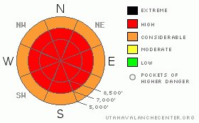
Danger Rose Tutorial
|
There’s a HIGH danger in the Logan Area Backcountry today. Very dangerous avalanche conditions exist on numerous slopes steeper than about 30 degrees, especially on those with significant deposits of wind-drifted snow. Avalanches, at mid and upper elevations could break into deeply buried weak layers and be very large, dangerous, and potentially destructive. We strongly recommend that you stay out of avalanche terrain today.... Avoid and stay well out from under all steep mountain slopes and obvious or historic avalanche paths...
|
|
|
CURRENT CONDITIONS |

|
Very strong and sustained south winds yesterday drifted tons of fresh and falling snow into lee terrain. This caused a HIGH avalanche danger in the backcountry. Several more inches fell last night, after the damage was done, and all the obvious clues are now neatly hidden under nice benign-looking pow-pow.
South winds sustained 40+ mph averages at the CSI weather station on Logan Peak for many hours yesterday, while heavy snow fell in the mountains and rain in the Valley. The Tony Grove Snotel reports a good shot of snow yesterday and overnight, containing 1.3 inches inches of water. 13 inches of snow was added to the total depth a Franklin Basin and the Ben Lomond Snotel recorded an amaizing 4.3" of snow water equivelent in 24 hours...... |
|
|
RECENT ACTIVITY |

|
Tragedy struck hard in Cache Valley on Christmas Eve, when a huge hard slab avalanche on Logan Peak claimed two young lives . We wish to express our deepest condolences to the families, loved ones, and friends of Erik and Jesse. Our community is deeply wounded on this Christmas....
The avalanche, near the summit of the East Face of Logan Peak was 4 to 6+' deep and 2000'+ (est.) wide. (photos) It was a nasty hard slab, consisting of both old and newer wind-deposited snow, which overloaded weak sugary or faceted layers near the ground. The failure occurred deep in the snowpack, and I found weak snow both below and above the mid-November rain/crust, (fracture profile). The precise culprit weak layer is somewhat irrelevant, as the avalanche essentially pulled out all the snow to the ground once it started moving....
I noticed evidence a large natural avalanche in Tab Hollow on Christmas Eve, visible while driving down Logan Canyon. Significant natural avalanches likely occurred locally during yesterday's tempest, and I'll need reports from you to catalog these. Significant natural and human triggered avalanches continue to plague the Ogden Area Mountains and the Western Uinta, as well as the Central and Southern Wasatch Range.
|
|
|
THREAT #1 |

|
| WHERE |
PROBABILITY |
SIZE |
TREND |

|
|
|
|
| |
|
|
Over the next
24
hours.
|
|
|
Very strong and sustained south winds yesterday drifted tons of snow onto steep slopes at all elevations, but especially into lee slope fetch areas at upper elevations. These include many our classic and historic avalanche paths. Strong, sustained wind from a constant direction is bad enough, but couple these wind effects with periods of extremely heavy snowfall and you've got a widespread situation, because freshly deposited wind drifted snow is often quite sensitive to human weight and prone to avalanching.
Yesterday's fresh wind slabs will be nicely covered up and hidden by last night's accumulation of several inches of powder under much less windy conditions. Don't be fooled by this enticing surface fluff, the Dragon is lurking out there today... |
|
|
THREAT #2 |

|
| WHERE |
PROBABILITY |
SIZE |
TREND |

|
|
|
|
| |
|
|
Over the next
24
hours.
|
|
|
On many slopes in the region, the tremendous new weight of wind deposited snow is overloading deeply buried weak layers, and yesterday's additional load could be enough to cause avalanches to break on the basal layer of the snowpack. The tragic Christmas Eve avalanche on Logan Peak was an example of what is likely to occur on other upper elevation slopes in the region. The huge hard slab avalanche failed on well developed faceted snow associated with the prominent mid-November rain-crust. This crust/facet combo appears to be strong enough to allow large hard slabs to build up on it before failing, ( or worse, becoming critically balanced). Any such hard slab avalanche will be very large and quite destructive.
Avalanches breaking on weak faceted snow near the ground are also possible in mid-elevation terrain that wasn't afflicted by the mid-November rain-crust. Cold temperatures in the past few weeks have accelerated the sublimation process that causes faceting, especially on slopes with a shallow overall snow. Avalanches could break near the bottom of the snowpack on steep mid-elevation slopes...Watch for cut-banks and small terrain traps..... |
|
|
MOUNTAIN WEATHER |

|
Unsettled and moist weather will continue into the weekend, with a few additional inches in the mountains possible today and tomorrow and moderate west shifting to northwest winds. Continued moist and snowy weather will continue well into next week. |
|
|
GENERAL ANNOUNCEMENTS |
Today would be a great day to ride up at Beaver Mountain, which just opened up on Monday. You can support the Utah Avalanche Center and get discount lift tickets (here). All proceeds from sales will support us through the Friends of the Utah Avalanche Center......
If you have any observations from the backcountry, especially if you see or trigger an avalanche, please let us know. You can leave a message at (435) 755-3638 or 1-800-662-4140, or visit our Website, (utahavalanchecenter.org), and download observations directly to us.....
The UAC depends on contributions from users like you to support our work.
The information in this advisory is from the U.S.D.A. Forest Service, which is solely responsible for its content. This advisory describes general avalanche conditions and local variations always occur. |
|
|
This information does not apply to developed ski areas or highways where avalanche control is normally done. This advisory is from the U.S.D.A. Forest Service, which is solely responsible for its content. This advisory describes general avalanche conditions and local variations always occur. |
|
This advisory provided by the USDA Forest Service, in partnership with:
The Friends of the Utah Avalanche Center, Utah Division of State Parks and Recreation, Utah Division of Emergency Management, Salt Lake County, Salt Lake Unified Fire Authority and the friends of the La Sal Avalanche Center. See our Sponsors Page for a complete list. |
