AVALANCHE WARNING »
Dangerous avalanche conditions are occuring or are imminent.
Backcountry travel in avalanche terrain is not recommended.
|
 |
Notice: THIS AVALANCHE WARNING IS FOR THE MOUNTAINS OF NORTHERN AND CENTRAL UTAH INCLUDING THE BEAR RIVER RANGE, WESTERN UINTAS, WASATCH, TUSHARS AND MANTI SKYLINE. A POTENT STORM WILL EFFECT THE MOUNTAINS AND OVERLOAD AN EXISTING WEAK SNOWPACK. THIS WILL RESULT IN NATURAL AVALANCHE ACTIVITY. HUMAN TRIGGERED AVALANCHES ARE ALMOST CERTAIN ON MANY HIGH ELEVATION SLOPES. THE UTAH AVALANCHE CENTER IS RECOMMENDING THAT PEOPLE AVOID THE BACKCOUNTRY UNTIL CONDITIONS IMPROVE. THE AVALANCHE DANGER WILL LINGER INTO THE WEEKEND EVEN THOUGH WE MAY SEE SOME CLEARING OF THE WEATHER. |
|
|
BOTTOM LINE
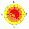
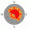
Danger by aspect and elevation on slopes approaching 35° or steeper.
(click HERE for tomorrow's danger rating)
|
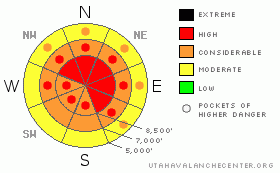
Danger Rose Tutorial
|
There’s a HIGH danger in the Logan Area Backcountry today. Very dangerous avalanche conditions exist on numerous slopes steeper than about 30 degrees, especially on upper elevation slopes with significant deposits of wind-drifted snow. Avalanches could step down into old buried weak layers and be large dangerous and destructive. Please stay out of avalanche terrain today.... Avoid and stay well out from under steep mountain slopes and obvious or historic avalanche paths...
|
|
|
CURRENT CONDITIONS |

|
South winds increased significantly overnight, and the Campbell Scientific weather station on Logan Peak recorded 25 mph average windspeeds with gusts approaching 60 early this morning...It's 16 degrees and snowing at 9400'. The strong winds continue to drift a tremendous amount of snow into large upper elevation avalanche stating zones, both during periods of heavy snowfall and when there's lots of fresh powder on the ground... |
|
|
RECENT ACTIVITY |

|
Tragedy struck hard in Cache Valley yesterday, when a huge hard slab avalanche on Logan Peak claimed the lives of Erik Jorgenson of Paradise and Jesse Ryan Johnson of Hyrum. We wish to express our deepest condolences to the families, loved ones, and friends of these young men. Our community is deeply wounded on this Christmas....
The avalanche, near the summit of the East Face of Logan Peak was 4 to 6+' deep and 2000'+ (est.) wide. (photos) It was a nasty hard slab, consisting of both old and newer wind-deposited snow, which overloaded weak sugary or faceted layers near the ground. The failure occurred deep in the snowpack, and I found weak snow both below and above the mid-November rain/crust, (fracture profile). The precise culprit weak layer is somewhat irrelevant, as the avalanche essentially pulled out all the snow to the ground once it started moving....
Significant natural and human triggered avalanches continued to plague the Ogden Area Mountains as well as the Central and Southern Wasatch Range, and the Western Uintas. Numerous avalanches were triggered in the backcountry on Christmas Eve, by snowmobilers, skiers, snowboarders and others who are just looking for a little untracked powder to try out their new toys in.....The list of recent avalanches in the State continues to grow at an alarming rate (see Wasatch avalanche list).
|
|
|
THREAT #1 |

|
| WHERE |
PROBABILITY |
SIZE |
TREND |
|
|
|
|
| |
|
|
Over the next
24
hours.
|
|
|
Additional loading from snowfall and winds today will continue to increase the danger on steep slopes with significant deposits of drifted snow. Watch for and avoid areas with fresh drifts of smooth, stiffer, wind deposited snow especially in and around terrain features like gullies, cliff bands or roll-offs. Extensive wind loading in lee terrain has occurred in the last week and continues today... |
|
|
THREAT #2 |

|
| WHERE |
PROBABILITY |
SIZE |
TREND |
|
|
|
|
| |
|
|
Over the next
24
hours.
|
|
|
Avalanches on some slopes are likely to break into older snow layers with today's additional load . My biggest concern is the well developed faceted snow associated with the prominent mid-November rain-crust. This crust/facet combo is strong enough to allow a large hard slab to build up on it before failing, ( or worse, becoming critically balanced). Today's additional load could be enough to cause avalanches to break on the basal layer of the snowpack. Any such avalanche would be large and quite destructive.
Avalanches breaking on weak faceted snow near the ground are possible in terrain that didn't have much or any snow cover in November. Cold temperatures in the past two weeks have accelerated the sublimation process that causes faceting, especially on slopes with a shallow overall snow. additional loading could cause slab avalanches to break near the bottom of the snowpack on some steep mid-elevation slopes... |
|
|
MOUNTAIN WEATHER |

|
A strong winter storm will blast the region today with strong winds and heavy snowfall. A foot of accumulation is possible at upper elevations today. Blustery west winds will continue tonight as will snowfall...The winds will shift from the northwest and diminish a bit tomorrow, with light snowfall... Unsettled and moist weather will continue into next week... |
|
|
GENERAL ANNOUNCEMENTS |
Beaver Mountain opened on Monday, and you can get discount lift tickets (here). All proceeds from sales will support the Utah Avalanche Center through the Friends of the Utah Avalanche Center......
If you have observations from the backcountry, especially if you see or trigger an avalanche, please let us know. You can leave a message at (435) 755-3638 or 1-800-662-4140, or email us at uac@utahavalanchecenter.org. (Fax 801-524-6301).
The UAC depends on contributions from users like you to support our work. To find out more about how you can support our efforts to continue providing the avalanche forecasting and education that you expect please visit our Friends page.
The information in this advisory is from the U.S.D.A. Forest Service, which is solely responsible for its content. This advisory describes general avalanche conditions and local variations always occur. |
|
|
This information does not apply to developed ski areas or highways where avalanche control is normally done. This advisory is from the U.S.D.A. Forest Service, which is solely responsible for its content. This advisory describes general avalanche conditions and local variations always occur. |
|
This advisory provided by the USDA Forest Service, in partnership with:
The Friends of the Utah Avalanche Center, Utah Division of State Parks and Recreation, Utah Division of Emergency Management, Salt Lake County, Salt Lake Unified Fire Authority and the friends of the La Sal Avalanche Center. See our Sponsors Page for a complete list. |
