AVALANCHE WARNING »
Dangerous avalanche conditions are occuring or are imminent.
Backcountry travel in avalanche terrain is not recommended.
|
 |
Notice: We've issued an Avalanche Warning for the mountains of Northern Utah..... |
|
|
SPECIAL ANNOUNCEMENT |
 |
Beaver Mountain opened on Monday, and you can get discount lift tickets (here). All proceeds from sales will support the Utah Avalanche Center through the Friends of the Utah Avalanche Center...... |
|
|
BOTTOM LINE
Danger by aspect and elevation on slopes approaching 35° or steeper.
(click HERE for tomorrow's danger rating)
|
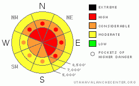
Danger Rose Tutorial
|
There’s a CONSIDERABLE danger in the backcountry today and dangerous avalanche conditions exist on numerous slopes steeper than about 35 degrees, especially on those with recent deposits of wind-drifted snow. Avalanches on some slopes could step down into old buried weak layers and be large dangerous and destructive. Use conservative decision making, careful route finding and good travel habits in the backcountry. Training and experience are essential.
The danger is likely the rise to HIGH overnight and for Christmas Day
Avoid steep slopes and obvious or historic avalanche paths...
|
|
|
CURRENT CONDITIONS |

|
There's lots of light powder at all elevations, with bushes and rocks still a major factor at lower and mid-elevations and fairly deep snow coverage up high in the Central Bear River Range. The local 8000+ Snotel sites uniformly reported around 1.5 inches of water, and that translated into a foot to 18 inches of new snow on the slopes we visited yesterday. The Tony Grove Snotel now reports just under 50" of total snow on the ground...
We'll see another fairly strong winter storm beginning later today in the mountains, with strong gusty winds and significant heavy snowfall in the forecast. A foot or two of accumulation is expected at upper elevations by the end of Christmas Day. As fresh snow is drifted into avalanche starting zones, the avalanche danger will increase accordingly.
Overnight west winds at the Campbell Scientific weather station on Logan Peak appear to be increasing a bit, with gusts to 30 mph early this morning. It's 2 degrees at 9400'. |
|
|
RECENT ACTIVITY |

|
We noted evidence of widespread natural soft slab avalanches above 8000' in the Tony Grove Area (photo's). These involved drifted new snow, and probably occurred during a period of heavy accumulation rates in the midst of Monday' s energetic storm. We also were easily able to trigger small soft slabs, 1 to 1.5 deep, running on surface hoar (frost crystals) formed Saturday night. It looked like a few avalanche paths in the Wellsville Range may have run naturally, as several of the long run-out gullies show signs of being filled in....
Significant natural and human triggered avalanches continued to plague the Ogden Area Mountains as well as the Central and Southern Wasatch Range, and the Western Uintas. The list of recent backcountry avalanches in the State continues to grow at an alarming rate (see Wasatch avalanche list).
It's only a matter of time (and weight) before we start seeing dangerous and large avalanches breaking into old snow in some areas.....Buried weak layers are present and a slab is building up on top of them. It's difficult to tell exactly when a slope will reach the critical balance that will allow you to trigger it, but odds are it'll be a storm like today's that does the trick. |
|
|
THREAT #1 |

|
| WHERE |
PROBABILITY |
SIZE |
TREND |

|
|
|
|
| |
|
|
Over the next
24 hours.
|
|
|
On many slopes, the new storm snow and fresh wind slabs stacked up on weak surface snow consisting frost crystals or surface hoar that formed overnight under clear sky conditions Saturday night. Many slopes steeper than about 35 degrees were still quite sensitive yesterday, and this type of weakness sometimes lingers for a few day's. Additional loading from snowfall and winds today could increase the danger on steep slopes.
Watch for and avoid areas with fresh drifts of smooth, stiffer, wind deposited snow especially in and around terrain features like gullies, cliff bands or roll-offs. |
|
|
THREAT #2 |

|
| WHERE |
PROBABILITY |
SIZE |
TREND |
|
|
|
|
| |
|
|
Over the next
24 hours.
|
|
|
Avalanches on some slopes may break into older snow layers with today's additional load . My biggest concern is the well developed faceted snow directly under the prominent mid-November rain-crust. On some (mainly mid-elevation or shallow upper elevation) slopes this crust is deteriorating, and Yesterday's or tomorrow's additional load could be enough to cause avalanches to break on the basal layer of the snowpack. Any such avalanche would be large and quite destructive.
Avalanches breaking on weak faceted snow near the ground are possible in terrain that didn't have much or any snow cover in November. Cold temperatures in the past two weeks have accelerated the sublimation process that causes faceting, especially on slopes with a shallow overall snow. additional loading could cause slab avalanches to break near the bottom of the snowpack on some steep mid-elevation slopes... |
|
|
MOUNTAIN WEATHER |

|
Expect increasing wind and developing snowfall later today. Winds and snowfall will increase drastically this evening. Santa will need the best of his navigation skills to make the rounds, and we'll be in the grip of a serious winter storm tonight through Christmas Day. Snow will continue in a northwesterly flow on Friday, and a moist and productive weather pattern will continue into the weekend, though it looks like most of the storm energy will be to our north.... |
|
|
GENERAL ANNOUNCEMENTS |
If you have observations from the backcountry, especially if you see or trigger an avalanche, please let us know. You can leave a message at (435) 755-3638 or 1-800-662-4140, or email us at uac@utahavalanchecenter.org. (Fax 801-524-6301).
The UAC depends on contributions from users like you to support our work. To find out more about how you can support our efforts to continue providing the avalanche forecasting and education that you expect please visit our Friends page.
The information in this advisory is from the U.S.D.A. Forest Service, which is solely responsible for its content. This advisory describes general avalanche conditions and local variations always occur. |
|
|
This information does not apply to developed ski areas or highways where avalanche control is normally done. This advisory is from the U.S.D.A. Forest Service, which is solely responsible for its content. This advisory describes general avalanche conditions and local variations always occur. |
|
This advisory provided by the USDA Forest Service, in partnership with:
The Friends of the Utah Avalanche Center, Utah Division of State Parks and Recreation, Utah Division of Emergency Management, Salt Lake County, Salt Lake Unified Fire Authority and the friends of the La Sal Avalanche Center. See our Sponsors Page for a complete list. |
